Property Record
713 Mcnatt St, Vidalia, GA 30474

This Property Is For Sale
NEARBY LISTINGS FOR SALE OR LEASE
Property Detail
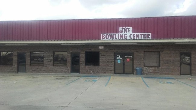
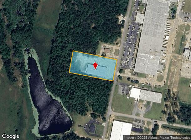
713 Mcnatt St
C28A068B01
2.50 AC-713 MCNATT ST-FASTCATS BOWLING
Commercialnec
Toombs
X
Georgia
13209C0150C
2.50 AC
2025
Georgia South Area
2025
Other Market Areas
970400
Vidalia, GA
20,000 SF
DEMOGRAPHICS near 713 Mcnatt St
1 Mile
3 Mile
5 Mile
2024 Total Population
1,816
10,512
19,427
2029 Population
1,783
10,498
19,327
Pop Growth 2024-2029
(1.82%)
(0.13%)
(0.51%)
Average Age
39
40
39
2024 Total Households
737
4,182
7,623
HH Growth 2024-2029
(1.63%)
(0.10%)
(0.50%)
Median Household Inc
$43,701
$42,942
$43,873
Avg Household Size
2.40
2.40
2.50
2024 Avg HH Vehicles
2.00
2.00
2.00
Median Home Value
$138,484
$161,506
$134,644
Median Year Built
1985
1978
1980
Nearby Places
Map Layers
Map Styles
 Street
 Aerial
- Restaurants
- Banks
- Shops
- Fitness
- Groceries
Nearby Properties
Address
Land Use
TOTAL SIZE
Lot Size
Zoning
Address
Land Use
TOTAL SIZE
Lot Size
Zoning
10,960 SF
1.03 AC
RESIDENTIA
Address
Land Use
TOTAL SIZE
Lot Size
Zoning
194,662 SF
20.17 AC
RESIDENTIA
Address
Land Use
TOTAL SIZE
Lot Size
Zoning
170,641 SF
10.10 AC
RESIDENTIA
Address
Land Use
TOTAL SIZE
Lot Size
Zoning
82,078 SF
45.80 AC
RESIDENTIA
Address
Land Use
TOTAL SIZE
Lot Size
Zoning
467,851 SF
48.13 AC
RESIDENTIA
Address
Land Use
TOTAL SIZE
Lot Size
Zoning
100,303 SF
102.82 AC
RESIDENTIA
Address
Land Use
TOTAL SIZE
Lot Size
Zoning
88,219 SF
80.25 AC
RESIDENTIA
Address
Land Use
TOTAL SIZE
Lot Size
Zoning
35,403 SF
13.25 AC
RESIDENTIA
Address
Land Use
TOTAL SIZE
Lot Size
Zoning
44,716 SF
8.83 AC
RESIDENTIA
Address
Land Use
TOTAL SIZE
Lot Size
Zoning
209,643 SF
22.05 AC
COMMERCIAL
Address
Land Use
TOTAL SIZE
Lot Size
Zoning
359,856 SF
18.72 AC
UNZONED RU
Address
Land Use
TOTAL SIZE
Lot Size
Zoning
2,226 SF
8.95 AC
RESIDENTIA
Address
Land Use
TOTAL SIZE
Lot Size
Zoning
18,078 SF
67.43 AC
COMMERCIAL
Address
Land Use
TOTAL SIZE
Lot Size
Zoning
42,708 SF
4.75 AC
COMMERCIAL
Address
Land Use
TOTAL SIZE
Lot Size
Zoning
50,668 SF
2.07 AC
RESIDENTIA
Address
Land Use
TOTAL SIZE
Lot Size
Zoning
27,416 SF
9.76 AC
RESIDENTIA
Address
Land Use
TOTAL SIZE
Lot Size
Zoning
108,953 SF
12.58 AC
COMMERCIAL
Address
Land Use
TOTAL SIZE
Lot Size
Zoning
63,374 SF
3.96 AC
RESIDENTIA
Address
Land Use
TOTAL SIZE
Lot Size
Zoning
43,987 SF
1.09 AC
RESIDENTIA
Address
Land Use
TOTAL SIZE
Lot Size
Zoning
135,715 SF
10.42 AC
COMMERCIAL
Address
Land Use
TOTAL SIZE
Lot Size
Zoning
2,248 SF
5.67 AC
COMMERCIAL
Address
Land Use
TOTAL SIZE
Lot Size
Zoning
119,047 SF
6 AC
COMMERCIAL
Address
Land Use
TOTAL SIZE
Lot Size
Zoning
15,340 SF
18.80 AC
RESIDENTIA
Address
Land Use
TOTAL SIZE
Lot Size
Zoning
15,094 SF
0.38 AC
COMMERCIAL
Address
Land Use
TOTAL SIZE
Lot Size
Zoning
103,924 SF
12.36 AC
RESIDENTIA
Address
Land Use
TOTAL SIZE
Lot Size
Zoning
44,352 SF
1.61 AC
COMMERCIAL
Address
Land Use
TOTAL SIZE
Lot Size
Zoning
25,358 SF
0.66 AC
COMMERCIAL
Address
Land Use
TOTAL SIZE
Lot Size
Zoning
2,701 SF
18.34 AC
RESIDENTIA
Address
Land Use
TOTAL SIZE
Lot Size
Zoning
37,293 SF
9.77 AC
COMMERCIAL
Address
Land Use
TOTAL SIZE
Lot Size
Zoning
22,034 SF
0.62 AC
COMMERCIAL
The World's #1 Commercial Real Estate Marketplace
Connect with us
© 2026 CoStar Group
The information above has been obtained from sources believed reliable. While we do not doubt its accuracy we have not verified it and make no guarantee, warranty or representation about it. It is your responsibility to independently confirm its accuracy and completeness. Any projections, opinions, assumptions, or estimates used are for example only and do not represent the current or future performance of the property. The value of this transaction to you depends on tax and other factors which should be evaluated by your tax, financial, and legal advisors. You and your advisors should conduct a careful, independent investigation of the property to determine to your satisfaction the suitability of the property for your needs.