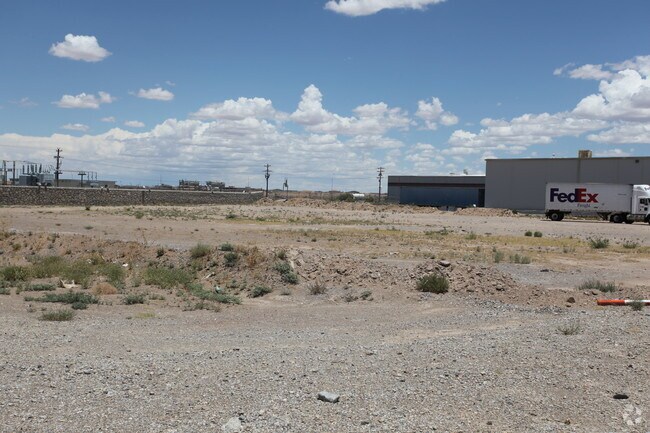
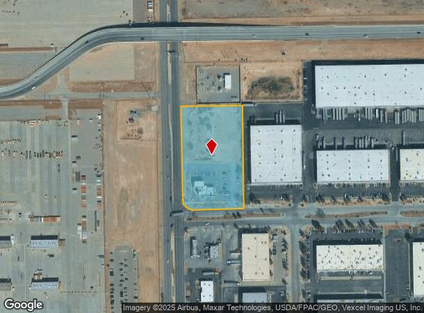
Property Record
7130 Airport Rd, El Paso, TX 79906
Current Lease Availabilities
NEARBY LISTINGS FOR SALE OR LEASE
Property Detail
7130 Airport Rd
El Paso
Butterfield Trail Ind Pk Rpl A
El Paso, TX
3 BUTTERFIELD TRAIL IND PK RPL C LOT 1 (132858.00 SQ FT)
B853-999-0030-0100
El Paso
Governmentalpublicusegeneral
Texas
0
1
2025
3.05 AC
980000
Northeast Butterfield Trail
DEMOGRAPHICS near 7130 Airport Rd
1 Mile
3 Mile
5 Mile
2024 Total Population
3,076
51,659
176,644
2029 Population
3,120
52,567
179,167
Pop Growth 2024-2029
+ 1.43%
+ 1.76%
+ 1.43%
Average Age
25
35
38
2024 Total Households
356
17,266
65,143
HH Growth 2024-2029
+ 1.12%
+ 1.57%
+ 1.43%
Median Household Inc
$63,182
$37,453
$38,438
Avg Household Size
3.40
2.70
2.60
2024 Avg HH Vehicles
2.00
2.00
2.00
Median Home Value
$150,000
$124,490
$133,321
Median Year Built
2001
1965
1965
Nearby Places
- Restaurants
- Banks
- Shops
- Fitness
- Groceries
PUBLIC TRANSPORTATION
AIRPORT
El Paso International
DRIVE
WALK
Distance
El Paso International
16 min
6.9 mi
Freight Ports
Port of Corpus Christi
DRIVE
WALK
Distance
Port of Corpus Christi
680 min
692.4 mi
Nearby Properties
Address
Land Use
TOTAL SIZE
Lot Size
Zoning
Address
Land Use
TOTAL SIZE
Lot Size
Zoning
561,866 SF
27.25 AC
C4
Address
Land Use
TOTAL SIZE
Lot Size
Zoning
259,926 SF
250.23 AC
M1
Address
Land Use
TOTAL SIZE
Lot Size
Zoning
107.76 AC
C4
Address
Land Use
TOTAL SIZE
Lot Size
Zoning
374,839 SF
33.29 AC
C3S
Address
Land Use
TOTAL SIZE
Lot Size
Zoning
683,161 SF
M1
Address
Land Use
TOTAL SIZE
Lot Size
Zoning
271,746 SF
1.93 AC
C4
Address
Land Use
TOTAL SIZE
Lot Size
Zoning
190,770 SF
8.70 AC
C4S
Address
Land Use
TOTAL SIZE
Lot Size
Zoning
210,541 SF
2.45 AC
C3S
Address
Land Use
TOTAL SIZE
Lot Size
Zoning
74,907 SF
8.07 AC
C4
Address
Land Use
TOTAL SIZE
Lot Size
Zoning
142,532 SF
13.32 AC
C3S
Address
Land Use
TOTAL SIZE
Lot Size
Zoning
495,319 SF
36.42 AC
M1
Address
Land Use
TOTAL SIZE
Lot Size
Zoning
197,902 SF
30 AC
R4
Address
Land Use
TOTAL SIZE
Lot Size
Zoning
174,369 SF
6.47 AC
C4
Address
Land Use
TOTAL SIZE
Lot Size
Zoning
333,673 SF
15 AC
AO
Address
Land Use
TOTAL SIZE
Lot Size
Zoning
138,825 SF
23.17 AC
R3
Address
Land Use
TOTAL SIZE
Lot Size
Zoning
137,378 SF
10.05 AC
C3S
Address
Land Use
TOTAL SIZE
Lot Size
Zoning
164,884 SF
14.65 AC
C4
Address
Land Use
TOTAL SIZE
Lot Size
Zoning
83,251 SF
2.43 AC
M1
Address
Land Use
TOTAL SIZE
Lot Size
Zoning
74,244 SF
1.55 AC
C4
Address
Land Use
TOTAL SIZE
Lot Size
Zoning
87,042 SF
2.94 AC
C4S
Address
Land Use
TOTAL SIZE
Lot Size
Zoning
23,760 SF
124.65 AC
Address
Land Use
TOTAL SIZE
Lot Size
Zoning
180,932 SF
13.99 AC
R4H
Address
Land Use
TOTAL SIZE
Lot Size
Zoning
54,911 SF
2 AC
Address
Land Use
TOTAL SIZE
Lot Size
Zoning
320,991 SF
15.48 AC
M1
Address
Land Use
TOTAL SIZE
Lot Size
Zoning
318,880 SF
16.86 AC
M1
Address
Land Use
TOTAL SIZE
Lot Size
Zoning
125,035 SF
9.01 AC
C4
Address
Land Use
TOTAL SIZE
Lot Size
Zoning
109.74 AC
M1
Address
Land Use
TOTAL SIZE
Lot Size
Zoning
87,218 SF
3 AC
Address
Land Use
TOTAL SIZE
Lot Size
Zoning
62,282 SF
2.87 AC
C4
Address
Land Use
TOTAL SIZE
Lot Size
Zoning
83,218 SF
2.57 AC
M1
The World's #1 Commercial Real Estate Marketplace
Connect with us
© 2025 CoStar Group
The information above has been obtained from sources believed reliable. While we do not doubt its accuracy we have not verified it and make no guarantee, warranty or representation about it. It is your responsibility to independently confirm its accuracy and completeness. Any projections, opinions, assumptions, or estimates used are for example only and do not represent the current or future performance of the property. The value of this transaction to you depends on tax and other factors which should be evaluated by your tax, financial, and legal advisors. You and your advisors should conduct a careful, independent investigation of the property to determine to your satisfaction the suitability of the property for your needs.