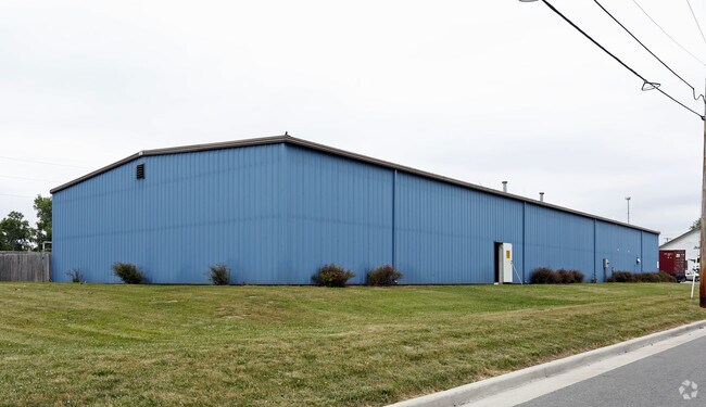
Property Record
7134 Railroad St, Holland, OH 43528

Property Detail
7134 Railroad St
71-00331
2 16 SE 1/4 S 150 FT E 240 FT W 530 FTON S LINE OF 300 FT
Storemultistory
Lucas
24-M1
Ohio
B and X Area of moderate flood hazard, usually the area between the limits of the 100-year and 500-year floods.
0.82 AC
0
South/Southwest
2025
Toledo
008802
Toledo, OH
13,680 SF
NEARBY LISTINGS FOR SALE OR LEASE
DEMOGRAPHICS near 7134 Railroad St
1 mile
3 mile
5 mile
2025 Total Population
5,412
48,301
117,769
2030 Population
5,276
47,853
116,316
Pop Growth 2025-2030
(2.51%)
(0.93%)
(1.23%)
Average Age
44
42
42
2025 Total Households
2,296
21,016
51,992
HH Growth 2025-2030
(2.48%)
(0.81%)
(1.18%)
Median Household Inc
$71,039
$70,963
$71,325
Avg Household Size
2.20
2.20
2.20
2025 Avg HH Vehicles
2.00
2.00
2.00
Median Home Value
$241,807
$241,966
$225,084
Median Year Built
1984
1983
1978
Nearby Places
Map Layers
Map Styles
 Street
 Aerial
Layers
 Traffic
 Biking
Places
Listings with unknown addresses are not visible on the map
- Restaurants
- Banks
- Shops
- Fitness
- Groceries
PUBLIC TRANSPORTATION
COMMUTER RAIL
Drive
Walk
Distance
17 min
9.8 mi
AIRPORT
Eugene F Kranz Toledo Express
Drive
Walk
Distance
Eugene F Kranz Toledo Express
22 min
10.2 mi
Freight Ports
Drive
Walk
Distance
30 min
15.9 mi
Nearby Properties
Address
Land Use
TOTAL SIZE
Lot Size
Zoning
Address
Land Use
TOTAL SIZE
Lot Size
Zoning
329,064 SF
69.74 AC
10-RS6
Address
Land Use
TOTAL SIZE
Lot Size
Zoning
186,190 SF
14 AC
19-C2
Address
Land Use
TOTAL SIZE
Lot Size
Zoning
196,149 SF
18.69 AC
10-RD6
Address
Land Use
TOTAL SIZE
Lot Size
Zoning
35.94 AC
17-C3
Address
Land Use
TOTAL SIZE
Lot Size
Zoning
211,140 SF
28.92 AC
10-IC
Address
Land Use
TOTAL SIZE
Lot Size
Zoning
138,607 SF
21.30 AC
10-RS12
Address
Land Use
TOTAL SIZE
Lot Size
Zoning
178,915 SF
13 AC
19-R3
Address
Land Use
TOTAL SIZE
Lot Size
Zoning
352,382 SF
62.93 AC
16-M1
Address
Land Use
TOTAL SIZE
Lot Size
Zoning
212,664 SF
21.43 AC
24-B3
Address
Land Use
TOTAL SIZE
Lot Size
Zoning
139,741 SF
30.48 AC
19-RA3
Address
Land Use
TOTAL SIZE
Lot Size
Zoning
203,839 SF
16.39 AC
24-SUP
Address
Land Use
TOTAL SIZE
Lot Size
Zoning
156,420 SF
12 AC
19-R3
Address
Land Use
TOTAL SIZE
Lot Size
Zoning
238,148 SF
18.20 AC
24-B3
Address
Land Use
TOTAL SIZE
Lot Size
Zoning
214,986 SF
17.55 AC
19-R1
Address
Land Use
TOTAL SIZE
Lot Size
Zoning
111,195 SF
13.64 AC
19-C2
Address
Land Use
TOTAL SIZE
Lot Size
Zoning
120,077 SF
9.53 AC
24-B3
Address
Land Use
TOTAL SIZE
Lot Size
Zoning
131,201 SF
10 AC
10-CUP
Address
Land Use
TOTAL SIZE
Lot Size
Zoning
126,732 SF
15 AC
10-CRSO
Address
Land Use
TOTAL SIZE
Lot Size
Zoning
58.33 AC
10-IL
Address
Land Use
TOTAL SIZE
Lot Size
Zoning
140,008 SF
10 AC
19-R3
Address
Land Use
TOTAL SIZE
Lot Size
Zoning
160,811 SF
10.83 AC
10-MX
Address
Land Use
TOTAL SIZE
Lot Size
Zoning
103,406 SF
7.55 AC
24-SUP
Address
Land Use
TOTAL SIZE
Lot Size
Zoning
60,805 SF
9.38 AC
10-RS12
Address
Land Use
TOTAL SIZE
Lot Size
Zoning
76,698 SF
7.70 AC
19-C2
Address
Land Use
TOTAL SIZE
Lot Size
Zoning
104,367 SF
10.51 AC
19-C2
Address
Land Use
TOTAL SIZE
Lot Size
Zoning
88,152 SF
11 AC
19-C2
Address
Land Use
TOTAL SIZE
Lot Size
Zoning
67,773 SF
5.85 AC
19-PO
Address
Land Use
TOTAL SIZE
Lot Size
Zoning
126,402 SF
6 AC
10-CRSO
Address
Land Use
TOTAL SIZE
Lot Size
Zoning
65,182 SF
8.40 AC
19-PO
Address
Land Use
TOTAL SIZE
Lot Size
Zoning
106,687 SF
11.48 AC
19-RA3
The World's #1 Commercial Real Estate Marketplace
Connect with us
© 2026 CoStar Group
The information above has been obtained from sources believed reliable. While we do not doubt its accuracy we have not verified it and make no guarantee, warranty or representation about it. It is your responsibility to independently confirm its accuracy and completeness. Any projections, opinions, assumptions, or estimates used are for example only and do not represent the current or future performance of the property. The value of this transaction to you depends on tax and other factors which should be evaluated by your tax, financial, and legal advisors. You and your advisors should conduct a careful, independent investigation of the property to determine to your satisfaction the suitability of the property for your needs.