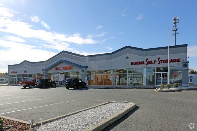
Property Record
714 S Harding Hwy, Buena, NJ 08310


Save to a Folder
{{folder.Name}}
{{folder.ListingIds.length}} Properties
{{folder.ListingIds.length}} Property
Create a New Folder
Property Detail
714 S Harding Hwy
Atlantic City-Hammonton, NJ
INCL BLK 201 LOTS 32 & 39
04-00201-0000-00039
Atlantic
Regionalshoppingcenterormallwithanchorstore
New Jersey
B and X Area of moderate flood hazard, usually the area between the limits of the 100-year and 500-year floods.
39
2025
3.90 AC
2026
Atlantic City/Hammonton
011300
Philadelphia
NEARBY LISTINGS FOR SALE OR LEASE
DEMOGRAPHICS near 714 S Harding Hwy
1 mile
3 mile
5 mile
2025 Total Population
2,744
7,633
31,991
2030 Population
2,708
7,626
32,444
Pop Growth 2025-2030
(1.31%)
(0.09%)
+ 1.42%
Average Age
42
42
42
2025 Total Households
1,044
2,982
12,192
HH Growth 2025-2030
(2.01%)
(0.50%)
+ 1.31%
Median Household Inc
$69,262
$72,392
$78,362
Avg Household Size
2.60
2.50
2.60
2025 Avg HH Vehicles
2.00
2.00
2.00
Median Home Value
$224,479
$240,662
$248,067
Median Year Built
1966
1969
1971
Nearby Places
Map Layers
Map Styles
 Street
 Aerial
Layers
 Traffic
 Biking
Places
Listings with unknown addresses are not visible on the map
- Restaurants
- Banks
- Shops
- Fitness
- Groceries
PUBLIC TRANSPORTATION
AIRPORT
Atlantic City International
Drive
Walk
Distance
Atlantic City International
54 min
24.2 mi
Philadelphia International
Drive
Walk
Distance
Philadelphia International
63 min
39.4 mi
Freight Ports
Broadway Terminal - Pier 5
Drive
Walk
Distance
Broadway Terminal - Pier 5
47 min
30.9 mi
SALE & LEASE HISTORY
LISTING DATE
SALE/LEASE

Jun 07, 2019
For Lease
Nearby Properties
Address
Land Use
TOTAL SIZE
Lot Size
Zoning
Address
Land Use
TOTAL SIZE
Lot Size
Zoning
286.98 AC
RDR1
Address
Land Use
TOTAL SIZE
Lot Size
Zoning
8.53 AC
R-3
Address
Land Use
TOTAL SIZE
Lot Size
Zoning
32.41 AC
A
Address
Land Use
TOTAL SIZE
Lot Size
Zoning
11.44 AC
RA/B
Address
Land Use
TOTAL SIZE
Lot Size
Zoning
11.67 AC
Address
Land Use
TOTAL SIZE
Lot Size
Zoning
22.81 AC
R-4
Address
Land Use
TOTAL SIZE
Lot Size
Zoning
13.23 AC
Address
Land Use
TOTAL SIZE
Lot Size
Zoning
32.34 AC
Address
Land Use
TOTAL SIZE
Lot Size
Zoning
103.71 AC
NOTE
Address
Land Use
TOTAL SIZE
Lot Size
Zoning
6.16 AC
B1
Address
Land Use
TOTAL SIZE
Lot Size
Zoning
3.48 AC
B3
Address
Land Use
TOTAL SIZE
Lot Size
Zoning
3.07 AC
R-2
Address
Land Use
TOTAL SIZE
Lot Size
Zoning
7.94 AC
R2
Address
Land Use
TOTAL SIZE
Lot Size
Zoning
4.28 AC
R-3
Address
Land Use
TOTAL SIZE
Lot Size
Zoning
0.60 AC
R-2
Address
Land Use
TOTAL SIZE
Lot Size
Zoning
9.77 AC
RA
Address
Land Use
TOTAL SIZE
Lot Size
Zoning
8.25 AC
A
Address
Land Use
TOTAL SIZE
Lot Size
Zoning
4.74 AC
Address
Land Use
TOTAL SIZE
Lot Size
Zoning
414 SF
4.94 AC
Address
Land Use
TOTAL SIZE
Lot Size
Zoning
10.58 AC
Address
Land Use
TOTAL SIZE
Lot Size
Zoning
1,072 SF
6.05 AC
B1
Address
Land Use
TOTAL SIZE
Lot Size
Zoning
7,680 SF
81.88 AC
FA1
Address
Land Use
TOTAL SIZE
Lot Size
Zoning
11.59 AC
R-4
Address
Land Use
TOTAL SIZE
Lot Size
Zoning
5.86 AC
A
Address
Land Use
TOTAL SIZE
Lot Size
Zoning
18.80 AC
R-3
Address
Land Use
TOTAL SIZE
Lot Size
Zoning
1.75 AC
R-2
Address
Land Use
TOTAL SIZE
Lot Size
Zoning
3.80 AC
R4
Address
Land Use
TOTAL SIZE
Lot Size
Zoning
6.21 AC
Address
Land Use
TOTAL SIZE
Lot Size
Zoning
204.74 AC
FA1
Address
Land Use
TOTAL SIZE
Lot Size
Zoning
21.04 AC
FA1
The World's #1 Commercial Real Estate Marketplace
Connect with us
© 2026 CoStar Group
The information above has been obtained from sources believed reliable. While we do not doubt its accuracy we have not verified it and make no guarantee, warranty or representation about it. It is your responsibility to independently confirm its accuracy and completeness. Any projections, opinions, assumptions, or estimates used are for example only and do not represent the current or future performance of the property. The value of this transaction to you depends on tax and other factors which should be evaluated by your tax, financial, and legal advisors. You and your advisors should conduct a careful, independent investigation of the property to determine to your satisfaction the suitability of the property for your needs.