Property Record
7140 Nw 39Th Expy, Bethany, OK 73008
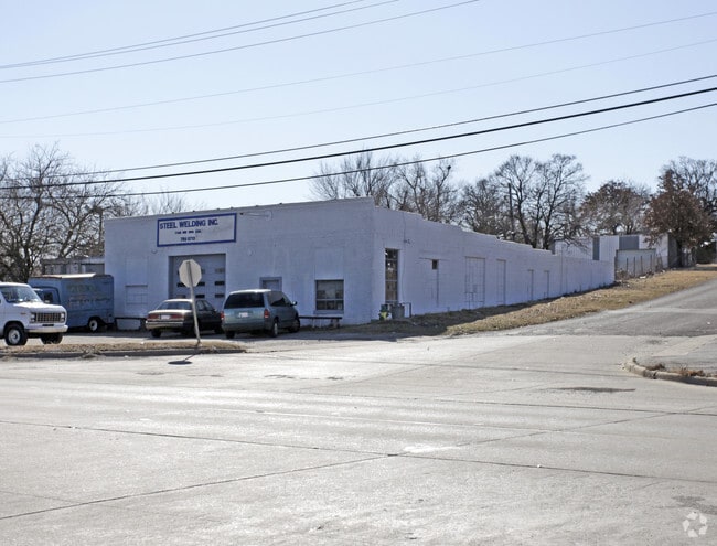

Property Detail
7140 Nw 39Th Expy
Oklahoma City, OK
OAK HILL SUB FOREST HGHLND 002 000 LOTS 8 THRU 13
173405000
OKLAHOMA
Lightindustrial
Oklahoma
B and X Area of moderate flood hazard, usually the area between the limits of the 100-year and 500-year floods.
8-13
2024
0.67 AC
2025
West
106704
Oklahoma City
5,200 SF
NEARBY LISTINGS FOR SALE OR LEASE
DEMOGRAPHICS near 7140 Nw 39Th Expy
1 mile
3 mile
5 mile
2025 Total Population
9,872
90,916
191,646
2030 Population
10,098
93,777
198,981
Pop Growth 2025-2030
+ 2.29%
+ 3.15%
+ 3.83%
Average Age
37
37
38
2025 Total Households
3,675
36,331
78,404
HH Growth 2025-2030
+ 2.48%
+ 3.31%
+ 3.65%
Median Household Inc
$53,371
$52,482
$62,225
Avg Household Size
2.40
2.40
2.40
2025 Avg HH Vehicles
2.00
2.00
2.00
Median Home Value
$196,136
$190,756
$220,725
Median Year Built
1961
1969
1972
Nearby Places
Map Layers
Map Styles
 Street
 Aerial
Transit
 Traffic
 Biking
Places
Listings with unknown addresses are not visible on the map
- Restaurants
- Banks
- Shops
- Fitness
- Groceries
PUBLIC TRANSPORTATION
AIRPORT
Will Rogers World
Drive
Walk
Distance
Will Rogers World
24 min
11.1 mi
SALE & LEASE HISTORY
LISTING DATE
SALE/LEASE

Jun 20, 2023
For Sale
Feb 24, 2022
For Sale
Nearby Properties
Address
Land Use
TOTAL SIZE
Lot Size
Zoning
Address
Land Use
TOTAL SIZE
Lot Size
Zoning
44,519 SF
3.39 AC
SPUD
Address
Land Use
TOTAL SIZE
Lot Size
Zoning
90,059 SF
14.99 AC
O-2
Address
Land Use
TOTAL SIZE
Lot Size
Zoning
49,950 SF
3.69 AC
R-1
Address
Land Use
TOTAL SIZE
Lot Size
Zoning
21,111 SF
2.57 AC
R-4
Address
Land Use
TOTAL SIZE
Lot Size
Zoning
213,085 SF
3.64 AC
Address
Land Use
TOTAL SIZE
Lot Size
Zoning
641,860 SF
62.12 AC
R-4
Address
Land Use
TOTAL SIZE
Lot Size
Zoning
29,274 SF
0.93 AC
C-3
Address
Land Use
TOTAL SIZE
Lot Size
Zoning
69,370 SF
O-2
Address
Land Use
TOTAL SIZE
Lot Size
Zoning
294,820 SF
12.17 AC
Address
Land Use
TOTAL SIZE
Lot Size
Zoning
225,084 SF
18.41 AC
Address
Land Use
TOTAL SIZE
Lot Size
Zoning
342,342 SF
27.20 AC
R-4
Address
Land Use
TOTAL SIZE
Lot Size
Zoning
245,768 SF
15.93 AC
Address
Land Use
TOTAL SIZE
Lot Size
Zoning
182,590 SF
11.35 AC
R-4
Address
Land Use
TOTAL SIZE
Lot Size
Zoning
172,368 SF
10.72 AC
R-4
Address
Land Use
TOTAL SIZE
Lot Size
Zoning
197,019 SF
8.69 AC
R-4
Address
Land Use
TOTAL SIZE
Lot Size
Zoning
225,720 SF
9.60 AC
PUD
Address
Land Use
TOTAL SIZE
Lot Size
Zoning
182,948 SF
10 AC
Address
Land Use
TOTAL SIZE
Lot Size
Zoning
217,512 SF
8.79 AC
C-3
Address
Land Use
TOTAL SIZE
Lot Size
Zoning
259,024 SF
14.16 AC
R-4
Address
Land Use
TOTAL SIZE
Lot Size
Zoning
146,710 SF
8.76 AC
O-2
Address
Land Use
TOTAL SIZE
Lot Size
Zoning
161,199 SF
6.03 AC
PUD
Address
Land Use
TOTAL SIZE
Lot Size
Zoning
1,865 SF
32.08 AC
Address
Land Use
TOTAL SIZE
Lot Size
Zoning
33,173 SF
50.74 AC
Address
Land Use
TOTAL SIZE
Lot Size
Zoning
276,106 SF
18.37 AC
R-4
Address
Land Use
TOTAL SIZE
Lot Size
Zoning
156,016 SF
11.04 AC
PUD
Address
Land Use
TOTAL SIZE
Lot Size
Zoning
184,960 SF
9.11 AC
R-4
Address
Land Use
TOTAL SIZE
Lot Size
Zoning
165,745 SF
13.89 AC
C-3
Address
Land Use
TOTAL SIZE
Lot Size
Zoning
163,284 SF
6.76 AC
R-4
Address
Land Use
TOTAL SIZE
Lot Size
Zoning
19,050 SF
1.17 AC
C-3
Address
Land Use
TOTAL SIZE
Lot Size
Zoning
6,148 SF
2.50 AC
R-1
The World's #1 Commercial Real Estate Marketplace
Connect with us
© 2026 CoStar Group
The information above has been obtained from sources believed reliable. While we do not doubt its accuracy we have not verified it and make no guarantee, warranty or representation about it. It is your responsibility to independently confirm its accuracy and completeness. Any projections, opinions, assumptions, or estimates used are for example only and do not represent the current or future performance of the property. The value of this transaction to you depends on tax and other factors which should be evaluated by your tax, financial, and legal advisors. You and your advisors should conduct a careful, independent investigation of the property to determine to your satisfaction the suitability of the property for your needs.