Property Record
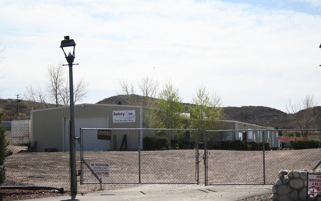
7144 Reynolds Dr, Sedalia, CO 80135


NEARBY LISTINGS FOR SALE OR LEASE
-
-
View all Sedalia listings for sale on LoopNet.com
Property Detail
7144 Reynolds Dr
Denver-Aurora-Lakewood, CO
Reynolds Industrial Park
2353-030-02-016
LOT 16 REYNOLDS INDUSTRIAL PARK 4.567 AM/L
Commercialnec
Douglas
X
Colorado
08035C0153G
16
2024
4.57 AC
2024
Southwest C-470
014135
Denver
4,350 SF
DEMOGRAPHICS near 7144 Reynolds Dr
1 Mile
3 Mile
5 Mile
2024 Total Population
40
726
49,347
2029 Population
45
823
55,849
Pop Growth 2024-2029
+ 12.50%
+ 13.36%
+ 13.18%
Average Age
40
42
39
2024 Total Households
13
248
16,036
HH Growth 2024-2029
+ 15.38%
+ 13.31%
+ 13.30%
Median Household Inc
$228,571
$186,538
$176,664
Avg Household Size
3.10
2.90
3.00
2024 Avg HH Vehicles
3.00
3.00
2.00
Median Home Value
$1,093,750
$1,050,000
$750,530
Median Year Built
2010
2005
2001
Nearby Places
Map Layers
Map Styles
 Street
 Aerial
- Restaurants
- Banks
- Shops
- Fitness
- Groceries
PUBLIC TRANSPORTATION
AIRPORT
Denver International
DRIVE
WALK
Distance
Denver International
59 min
49.4 mi
Nearby Properties
Address
Land Use
TOTAL SIZE
Lot Size
Zoning
Address
Land Use
TOTAL SIZE
Lot Size
Zoning
41,888 SF
154.73 AC
PDNU
Address
Land Use
TOTAL SIZE
Lot Size
Zoning
29,950 SF
4.53 AC
GI
Address
Land Use
TOTAL SIZE
Lot Size
Zoning
2,338 SF
320 AC
A1
Address
Land Use
TOTAL SIZE
Lot Size
Zoning
5,000 SF
36.99 AC
PDU
Address
Land Use
TOTAL SIZE
Lot Size
Zoning
8,770 SF
40.75 AC
Address
Land Use
TOTAL SIZE
Lot Size
Zoning
22,595 SF
2.21 AC
GI
Address
Land Use
TOTAL SIZE
Lot Size
Zoning
30,357 SF
1.90 AC
GI
Address
Land Use
TOTAL SIZE
Lot Size
Zoning
20,000 SF
2.79 AC
GI
Address
Land Use
TOTAL SIZE
Lot Size
Zoning
29,949 SF
79.43 AC
GI
Address
Land Use
TOTAL SIZE
Lot Size
Zoning
14,380 SF
3.11 AC
Address
Land Use
TOTAL SIZE
Lot Size
Zoning
20,732 SF
2.97 AC
GI
Address
Land Use
TOTAL SIZE
Lot Size
Zoning
12,000 SF
3.98 AC
GI
Address
Land Use
TOTAL SIZE
Lot Size
Zoning
2,448 SF
11.64 AC
Address
Land Use
TOTAL SIZE
Lot Size
Zoning
1 SF
35.31 AC
PDU
Address
Land Use
TOTAL SIZE
Lot Size
Zoning
12,000 SF
1.52 AC
GI
Address
Land Use
TOTAL SIZE
Lot Size
Zoning
4,250 SF
19.10 AC
GI
Address
Land Use
TOTAL SIZE
Lot Size
Zoning
9,869 SF
1.34 AC
GI
Address
Land Use
TOTAL SIZE
Lot Size
Zoning
9,633 SF
2.13 AC
GI
Address
Land Use
TOTAL SIZE
Lot Size
Zoning
12,300 SF
2.97 AC
GI
Address
Land Use
TOTAL SIZE
Lot Size
Zoning
23,014 SF
4.51 AC
RR
Address
Land Use
TOTAL SIZE
Lot Size
Zoning
6,768 SF
5.36 AC
GI
Address
Land Use
TOTAL SIZE
Lot Size
Zoning
9,600 SF
1.17 AC
GI
Address
Land Use
TOTAL SIZE
Lot Size
Zoning
8,820 SF
2.21 AC
GI
Address
Land Use
TOTAL SIZE
Lot Size
Zoning
8,611 SF
1.62 AC
GI
Address
Land Use
TOTAL SIZE
Lot Size
Zoning
8,480 SF
2.67 AC
GI
Address
Land Use
TOTAL SIZE
Lot Size
Zoning
19,375 SF
6.45 AC
GI
Address
Land Use
TOTAL SIZE
Lot Size
Zoning
8,400 SF
2.15 AC
GI
Address
Land Use
TOTAL SIZE
Lot Size
Zoning
5,865 SF
1.41 AC
B
Address
Land Use
TOTAL SIZE
Lot Size
Zoning
5,400 SF
2.21 AC
LI
Address
Land Use
TOTAL SIZE
Lot Size
Zoning
6,950 SF
4.77 AC
GI
The World's #1 Commercial Real Estate Marketplace
Connect with us
© 2025 CoStar Group
The information above has been obtained from sources believed reliable. While we do not doubt its accuracy we have not verified it and make no guarantee, warranty or representation about it. It is your responsibility to independently confirm its accuracy and completeness. Any projections, opinions, assumptions, or estimates used are for example only and do not represent the current or future performance of the property. The value of this transaction to you depends on tax and other factors which should be evaluated by your tax, financial, and legal advisors. You and your advisors should conduct a careful, independent investigation of the property to determine to your satisfaction the suitability of the property for your needs.