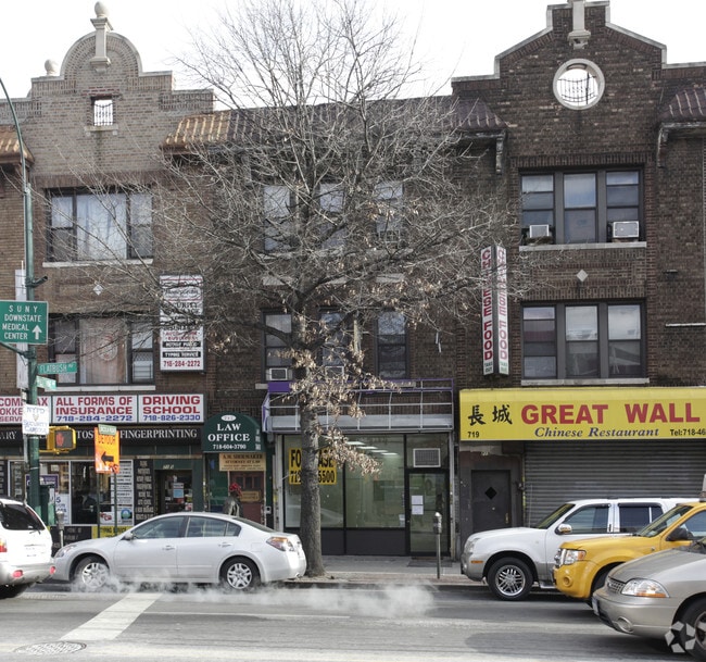
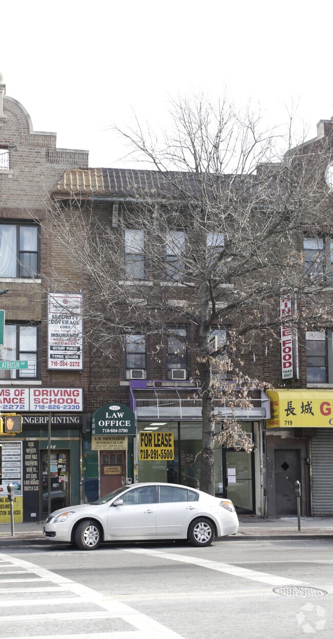
Property Record
715 Flatbush Ave, Brooklyn, NY 11226


Save to a Folder
{{folder.Name}}
{{folder.ListingIds.length}} Properties
{{folder.ListingIds.length}} Property
Create a New Folder
Property Detail
715 Flatbush Ave
05055-0012
Kings
Apartment
New York
R7-1
12
B and X Area of moderate flood hazard, usually the area between the limits of the 100-year and 500-year floods.
0.04 AC
2025
North Brooklyn
2026
Long Island (New York)
079601
New York-Jersey City-White Plains, NY-NJ
7,883 SF
NEARBY LISTINGS FOR SALE OR LEASE
DEMOGRAPHICS near 715 Flatbush Ave
1 mile
3 mile
5 mile
2025 Total Population
172,242
1,330,929
2,718,623
2030 Population
174,825
1,318,881
2,693,637
Pop Growth 2025-2030
+ 1.50%
(0.91%)
(0.92%)
Average Age
41
39
39
2025 Total Households
66,407
483,795
1,006,579
HH Growth 2025-2030
+ 1.20%
(1.10%)
(0.94%)
Median Household Inc
$83,862
$82,237
$80,639
Avg Household Size
2.50
2.60
2.60
2025 Avg HH Vehicles
.00
.00
1.00
Median Home Value
$932,358
$955,833
$914,512
Median Year Built
1947
1947
1948
Nearby Places
Map Layers
Map Styles
 Street
 Aerial
Layers
 Traffic
 Biking
Places
Listings with unknown addresses are not visible on the map
- Restaurants
- Banks
- Shops
- Fitness
- Groceries
PUBLIC TRANSPORTATION
TRANSIT/SUBWAY
Parkside Avenue (Q - New York MTA Subway (The Subway))
Drive
Walk
Distance
Parkside Avenue (Q - New York MTA Subway (The Subway))
2 min
3 min
0.1 mi
Church Avenue (B,Q Line) (B - New York MTA Subway (The Subway), Q - New York MTA Subway (The Subway))
Drive
Walk
Distance
Church Avenue (B,Q Line) (B - New York MTA Subway (The Subway), Q - New York MTA Subway (The Subway))
3 min
9 min
0.5 mi
Winthrop Street (2 - New York MTA Subway (The Subway), 5 - New York MTA Subway (The Subway))
Drive
Walk
Distance
Winthrop Street (2 - New York MTA Subway (The Subway), 5 - New York MTA Subway (The Subway))
3 min
10 min
0.5 mi
Prospect Park (B,Q,S Line) (B - New York MTA Subway (The Subway), Franklin Avenue Shuttle - New York MTA Subway (The Subway), Q - New York MTA Subway (The Subway))
Drive
Walk
Distance
Prospect Park (B,Q,S Line) (B - New York MTA Subway (The Subway), Franklin Avenue Shuttle - New York MTA Subway (The Subway), Q - New York MTA Subway (The Subway))
4 min
11 min
0.5 mi
Church Avenue (2,5 line) (2 - New York MTA Subway (The Subway), 5 - New York MTA Subway (The Subway))
Drive
Walk
Distance
Church Avenue (2,5 line) (2 - New York MTA Subway (The Subway), 5 - New York MTA Subway (The Subway))
3 min
16 min
0.8 mi
COMMUTER RAIL
Nostrand Avenue Station (Far Rockaway Branch - Long Island Rail Road, Hempstead Branch - Long Island Rail Road, Long Beach Branch - Long Island Rail Road, West Hempstead Branch - Long Island Rail Road)
Drive
Walk
Distance
Nostrand Avenue Station (Far Rockaway Branch - Long Island Rail Road, Hempstead Branch - Long Island Rail Road, Long Beach Branch - Long Island Rail Road, West Hempstead Branch - Long Island Rail Road)
7 min
2.0 mi
Drive
Walk
Distance
7 min
2.6 mi
AIRPORT
John F Kennedy International
Drive
Walk
Distance
John F Kennedy International
23 min
11.6 mi
LaGuardia
Drive
Walk
Distance
LaGuardia
25 min
11.7 mi
Newark Liberty International
Drive
Walk
Distance
Newark Liberty International
33 min
19.1 mi
Freight Ports
NY - Red Hook Container Terminal
Drive
Walk
Distance
NY - Red Hook Container Terminal
10 min
4.4 mi
SALE & LEASE HISTORY
LISTING DATE
SALE/LEASE

Jan 04, 2017
For Sale
Feb 28, 2024
For Lease
Nearby Properties
Address
Land Use
TOTAL SIZE
Lot Size
Zoning
Address
Land Use
TOTAL SIZE
Lot Size
Zoning
869,038 SF
1.53 AC
M1-1
Address
Land Use
TOTAL SIZE
Lot Size
Zoning
92,440 SF
466.23 AC
R5
Address
Land Use
TOTAL SIZE
Lot Size
Zoning
1,503,150 SF
20.47 AC
R5
Address
Land Use
TOTAL SIZE
Lot Size
Zoning
393.54 AC
PARK
Address
Land Use
TOTAL SIZE
Lot Size
Zoning
879,916 SF
1.35 AC
C6-4
Address
Land Use
TOTAL SIZE
Lot Size
Zoning
577,381 SF
3.19 AC
R6
Address
Land Use
TOTAL SIZE
Lot Size
Zoning
902,000 SF
3.21 AC
M3-1
Address
Land Use
TOTAL SIZE
Lot Size
Zoning
1,258,851 SF
2.20 AC
C6-4
Address
Land Use
TOTAL SIZE
Lot Size
Zoning
965,600 SF
6.65 AC
R5
Address
Land Use
TOTAL SIZE
Lot Size
Zoning
1,061,228 SF
8.86 AC
R5
Address
Land Use
TOTAL SIZE
Lot Size
Zoning
579,404 SF
4.80 AC
R6
Address
Land Use
TOTAL SIZE
Lot Size
Zoning
1,186,339 SF
0.99 AC
M14R72
Address
Land Use
TOTAL SIZE
Lot Size
Zoning
1,073,920 SF
16.53 AC
R6
Address
Land Use
TOTAL SIZE
Lot Size
Zoning
561,945 SF
11.58 AC
R6
Address
Land Use
TOTAL SIZE
Lot Size
Zoning
582,359 SF
0.99 AC
C6-4
Address
Land Use
TOTAL SIZE
Lot Size
Zoning
627,018 SF
1.21 AC
C6-4
Address
Land Use
TOTAL SIZE
Lot Size
Zoning
335,800 SF
1.51 AC
R6
Address
Land Use
TOTAL SIZE
Lot Size
Zoning
296,915 SF
0.31 AC
C5-3
Address
Land Use
TOTAL SIZE
Lot Size
Zoning
785,450 SF
14.22 AC
R6
Address
Land Use
TOTAL SIZE
Lot Size
Zoning
905,298 SF
1.60 AC
C61A
Address
Land Use
TOTAL SIZE
Lot Size
Zoning
1,324,592 SF
5.13 AC
M3-1
Address
Land Use
TOTAL SIZE
Lot Size
Zoning
61.60 AC
PARK
Address
Land Use
TOTAL SIZE
Lot Size
Zoning
565,326 SF
0.63 AC
C64.5
Address
Land Use
TOTAL SIZE
Lot Size
Zoning
566,000 SF
12.33 AC
R6
Address
Land Use
TOTAL SIZE
Lot Size
Zoning
600,000 SF
2.51 AC
R6B
Address
Land Use
TOTAL SIZE
Lot Size
Zoning
473,345 SF
1.27 AC
R8X
Address
Land Use
TOTAL SIZE
Lot Size
Zoning
389,125 SF
3.48 AC
C6-4
Address
Land Use
TOTAL SIZE
Lot Size
Zoning
489,344 SF
3.78 AC
C6-4
Address
Land Use
TOTAL SIZE
Lot Size
Zoning
710,746 SF
1.88 AC
C63A
Address
Land Use
TOTAL SIZE
Lot Size
Zoning
427,208 SF
1.30 AC
R6
The World's #1 Commercial Real Estate Marketplace
Connect with us
© 2026 CoStar Group
The information above has been obtained from sources believed reliable. While we do not doubt its accuracy we have not verified it and make no guarantee, warranty or representation about it. It is your responsibility to independently confirm its accuracy and completeness. Any projections, opinions, assumptions, or estimates used are for example only and do not represent the current or future performance of the property. The value of this transaction to you depends on tax and other factors which should be evaluated by your tax, financial, and legal advisors. You and your advisors should conduct a careful, independent investigation of the property to determine to your satisfaction the suitability of the property for your needs.