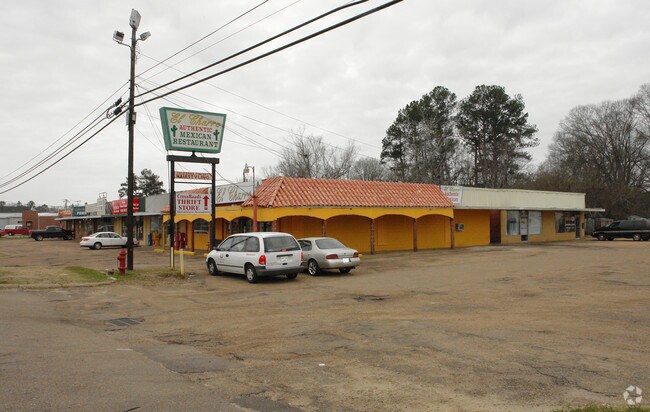
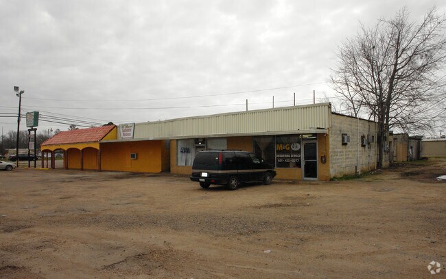
Property Record
715 Highway 49 S, Richland, MS 39218

NEARBY LISTINGS FOR SALE OR LEASE
Property Detail
715 Highway 49 S
Jackson, MS
Renno Sub
D07B-000050-00010
LOT 1 RENNO SUB LESS 0.31AC TO HWY ROW DB PG 236 0022982 DB 453 PG 0350 0110884 DB 643 PG 0068 0041092
Servicestation
Rankin
X
Mississippi
28121C0306G
1
2024
2.28 AC
2024
Outlying Rankin County
020401
Jackson
3,095 SF
DEMOGRAPHICS near 715 Highway 49 S
1 Mile
3 Mile
5 Mile
2024 Total Population
1,894
12,301
46,739
2029 Population
1,962
12,710
47,196
Pop Growth 2024-2029
+ 3.59%
+ 3.32%
+ 0.98%
Average Age
40
38
37
2024 Total Households
728
4,692
16,932
HH Growth 2024-2029
+ 3.71%
+ 3.32%
+ 1.05%
Median Household Inc
$46,447
$48,620
$40,834
Avg Household Size
2.50
2.60
2.50
2024 Avg HH Vehicles
2.00
2.00
2.00
Median Home Value
$144,224
$121,891
$112,001
Median Year Built
1986
1990
1976
Nearby Places
Map Layers
Map Styles
 Street
 Aerial
- Restaurants
- Banks
- Shops
- Fitness
- Groceries
PUBLIC TRANSPORTATION
COMMUTER RAIL
DRIVE
WALK
Distance
11 min
7.4 mi
AIRPORT
Jackson-Medgar Wiley Evers International
DRIVE
WALK
Distance
Jackson-Medgar Wiley Evers International
19 min
11.4 mi
Nearby Properties
Address
Land Use
TOTAL SIZE
Lot Size
Zoning
Address
Land Use
TOTAL SIZE
Lot Size
Zoning
58.94 AC
Address
Land Use
TOTAL SIZE
Lot Size
Zoning
123,308 SF
20.88 AC
Address
Land Use
TOTAL SIZE
Lot Size
Zoning
2,348 SF
16.45 AC
Address
Land Use
TOTAL SIZE
Lot Size
Zoning
139,417 SF
13.50 AC
Address
Land Use
TOTAL SIZE
Lot Size
Zoning
253,479 SF
17.08 AC
Address
Land Use
TOTAL SIZE
Lot Size
Zoning
67,442 SF
2.85 AC
Address
Land Use
TOTAL SIZE
Lot Size
Zoning
157,034 SF
17.28 AC
Address
Land Use
TOTAL SIZE
Lot Size
Zoning
7,840 SF
10.34 AC
Address
Land Use
TOTAL SIZE
Lot Size
Zoning
24,081 SF
24.48 AC
Address
Land Use
TOTAL SIZE
Lot Size
Zoning
71,705 SF
11.52 AC
Address
Land Use
TOTAL SIZE
Lot Size
Zoning
58,208 SF
2.41 AC
Address
Land Use
TOTAL SIZE
Lot Size
Zoning
214,011 SF
17.50 AC
Address
Land Use
TOTAL SIZE
Lot Size
Zoning
11,796 SF
2.97 AC
Address
Land Use
TOTAL SIZE
Lot Size
Zoning
28,073 SF
6.72 AC
Address
Land Use
TOTAL SIZE
Lot Size
Zoning
2,513 SF
7.10 AC
Address
Land Use
TOTAL SIZE
Lot Size
Zoning
7,648 SF
7.10 AC
Address
Land Use
TOTAL SIZE
Lot Size
Zoning
16,095 SF
11.11 AC
Address
Land Use
TOTAL SIZE
Lot Size
Zoning
55,092 SF
2.21 AC
Address
Land Use
TOTAL SIZE
Lot Size
Zoning
8,272 SF
8.15 AC
Address
Land Use
TOTAL SIZE
Lot Size
Zoning
5,595 SF
7.51 AC
Address
Land Use
TOTAL SIZE
Lot Size
Zoning
4,131 SF
27.84 AC
Address
Land Use
TOTAL SIZE
Lot Size
Zoning
47,809 SF
1.75 AC
Address
Land Use
TOTAL SIZE
Lot Size
Zoning
12.74 AC
Address
Land Use
TOTAL SIZE
Lot Size
Zoning
9,789 SF
23.22 AC
Address
Land Use
TOTAL SIZE
Lot Size
Zoning
59,724 SF
7.95 AC
Address
Land Use
TOTAL SIZE
Lot Size
Zoning
61,637 SF
10.77 AC
Address
Land Use
TOTAL SIZE
Lot Size
Zoning
5,616 SF
31.56 AC
Address
Land Use
TOTAL SIZE
Lot Size
Zoning
78,626 SF
3.12 AC
Address
Land Use
TOTAL SIZE
Lot Size
Zoning
24,864 SF
6.10 AC
Address
Land Use
TOTAL SIZE
Lot Size
Zoning
120,296 SF
6.02 AC
The World's #1 Commercial Real Estate Marketplace
Connect with us
© 2026 CoStar Group
The information above has been obtained from sources believed reliable. While we do not doubt its accuracy we have not verified it and make no guarantee, warranty or representation about it. It is your responsibility to independently confirm its accuracy and completeness. Any projections, opinions, assumptions, or estimates used are for example only and do not represent the current or future performance of the property. The value of this transaction to you depends on tax and other factors which should be evaluated by your tax, financial, and legal advisors. You and your advisors should conduct a careful, independent investigation of the property to determine to your satisfaction the suitability of the property for your needs.