Property Record
715 Kipling St, Lakewood, CO 80215


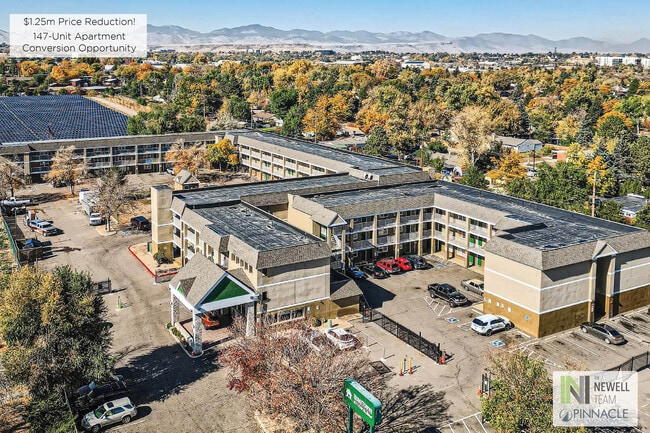

This Property Is For Sale
Property Detail
715 Kipling St
49-044-00-002
SECTION 04 TOWNSHIP 04 RANGE 69 QTR SE SIZE: 103150 VALUE: 2.368 KEY=120
Commercialnec
JEFFERSON
B and X Area of moderate flood hazard, usually the area between the limits of the 100-year and 500-year floods.
Colorado
2025
2.37 AC
2025
Denver West
010902
Denver
28,987 SF
Denver-Aurora-Centennial, CO
NEARBY LISTINGS FOR SALE OR LEASE
DEMOGRAPHICS near 715 Kipling St
1 mile
3 mile
5 mile
2025 Total Population
8,369
116,241
311,720
2030 Population
8,490
116,300
313,448
Pop Growth 2025-2030
+ 1.45%
+ 0.05%
+ 0.55%
Average Age
41
41
40
2025 Total Households
3,657
50,690
131,379
HH Growth 2025-2030
+ 1.45%
+ 0.03%
+ 0.61%
Median Household Inc
$68,578
$84,499
$89,645
Avg Household Size
2.20
2.20
2.30
2025 Avg HH Vehicles
2.00
2.00
2.00
Median Home Value
$589,005
$648,641
$651,856
Median Year Built
1968
1972
1971
Nearby Places
Map Layers
Map Styles
 Street
 Aerial
Layers
 Traffic
 Biking
Places
Listings with unknown addresses are not visible on the map
- Restaurants
- Banks
- Shops
- Fitness
- Groceries
PUBLIC TRANSPORTATION
COMMUTER RAIL
Arvada Ridge Station Track 1 (Union Station to Wheat Ridge Ward Station - Regional Transportation District)
Drive
Walk
Distance
Arvada Ridge Station Track 1 (Union Station to Wheat Ridge Ward Station - Regional Transportation District)
10 min
5.1 mi
Wheat Ridge - Ward Station Track 1 (Union Station to Wheat Ridge Ward Station - Regional Transportation District)
Drive
Walk
Distance
Wheat Ridge - Ward Station Track 1 (Union Station to Wheat Ridge Ward Station - Regional Transportation District)
12 min
5.7 mi
AIRPORT
Denver International
Drive
Walk
Distance
Denver International
43 min
32.3 mi
Freight Ports
Tulsa Port Of Catoosa
Drive
Walk
Distance
Tulsa Port Of Catoosa
740 min
717.8 mi
Nearby Properties
Address
Land Use
TOTAL SIZE
Lot Size
Zoning
Address
Land Use
TOTAL SIZE
Lot Size
Zoning
943,179 SF
23.96 AC
Address
Land Use
TOTAL SIZE
Lot Size
Zoning
82,133 SF
6.07 AC
Address
Land Use
TOTAL SIZE
Lot Size
Zoning
3,195,026 SF
562.97 AC
Address
Land Use
TOTAL SIZE
Lot Size
Zoning
133,938 SF
1.72 AC
Address
Land Use
TOTAL SIZE
Lot Size
Zoning
92,072 SF
2.98 AC
Address
Land Use
TOTAL SIZE
Lot Size
Zoning
94,560 SF
6.03 AC
Address
Land Use
TOTAL SIZE
Lot Size
Zoning
128,779 SF
3.80 AC
Address
Land Use
TOTAL SIZE
Lot Size
Zoning
1,193,158 SF
68.86 AC
Address
Land Use
TOTAL SIZE
Lot Size
Zoning
112,266 SF
2.41 AC
Address
Land Use
TOTAL SIZE
Lot Size
Zoning
111,544 SF
2.90 AC
Address
Land Use
TOTAL SIZE
Lot Size
Zoning
113,566 SF
4.94 AC
Address
Land Use
TOTAL SIZE
Lot Size
Zoning
71,706 SF
1.81 AC
Address
Land Use
TOTAL SIZE
Lot Size
Zoning
103,594 SF
1 AC
Address
Land Use
TOTAL SIZE
Lot Size
Zoning
76,685 SF
2.24 AC
Address
Land Use
TOTAL SIZE
Lot Size
Zoning
56,930 SF
7.59 AC
Address
Land Use
TOTAL SIZE
Lot Size
Zoning
53,912 SF
0.90 AC
Address
Land Use
TOTAL SIZE
Lot Size
Zoning
68,269 SF
0.95 AC
Address
Land Use
TOTAL SIZE
Lot Size
Zoning
90,776 SF
5 AC
Address
Land Use
TOTAL SIZE
Lot Size
Zoning
115,307 SF
2.40 AC
Address
Land Use
TOTAL SIZE
Lot Size
Zoning
53,503 SF
2.35 AC
Address
Land Use
TOTAL SIZE
Lot Size
Zoning
34,642 SF
C-MX-8
Address
Land Use
TOTAL SIZE
Lot Size
Zoning
60,906 SF
2.87 AC
Address
Land Use
TOTAL SIZE
Lot Size
Zoning
233,688 SF
22.37 AC
Address
Land Use
TOTAL SIZE
Lot Size
Zoning
45,703 SF
1.10 AC
Address
Land Use
TOTAL SIZE
Lot Size
Zoning
198,081 SF
Address
Land Use
TOTAL SIZE
Lot Size
Zoning
199,685 SF
27.73 AC
Address
Land Use
TOTAL SIZE
Lot Size
Zoning
232,678 SF
27.50 AC
Address
Land Use
TOTAL SIZE
Lot Size
Zoning
10,524 SF
2.58 AC
Address
Land Use
TOTAL SIZE
Lot Size
Zoning
187,745 SF
16.25 AC
Address
Land Use
TOTAL SIZE
Lot Size
Zoning
35,741 SF
0.80 AC
The World's #1 Commercial Real Estate Marketplace
Connect with us
© 2026 CoStar Group
The information above has been obtained from sources believed reliable. While we do not doubt its accuracy we have not verified it and make no guarantee, warranty or representation about it. It is your responsibility to independently confirm its accuracy and completeness. Any projections, opinions, assumptions, or estimates used are for example only and do not represent the current or future performance of the property. The value of this transaction to you depends on tax and other factors which should be evaluated by your tax, financial, and legal advisors. You and your advisors should conduct a careful, independent investigation of the property to determine to your satisfaction the suitability of the property for your needs.