Property Record
715 S Fiske Blvd, Cocoa, FL 32922

NEARBY LISTINGS FOR SALE OR LEASE
-
-
View all Cocoa listings for sale on LoopNet.com
Property Detail
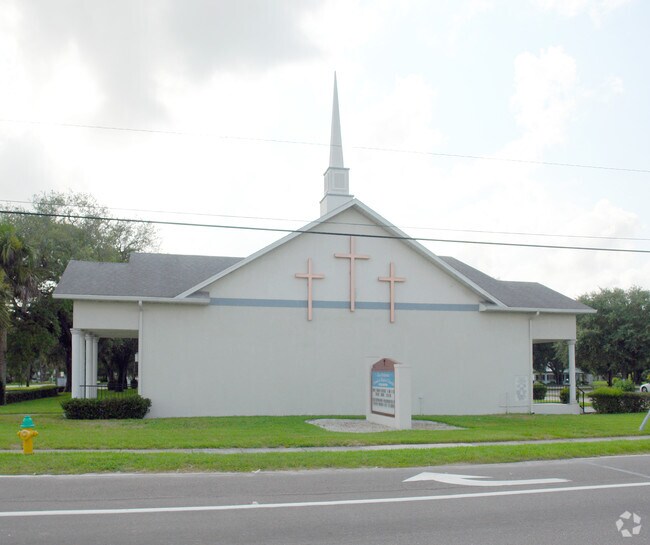
715 S Fiske Blvd
Palm Bay-Melbourne-Titusville, FL
Virginia Park
24-36-32-75-00025.0-0001.00
VIRGINIA PARK LOTS 1 TO 15 BLK 25
Religious
Brevard
X
Florida
12009C0426H
1
2024
2.19 AC
2025
Brevard County
062600
Orlando
13,691 SF
DEMOGRAPHICS near 715 S Fiske Blvd
1 Mile
3 Mile
5 Mile
2024 Total Population
8,774
48,691
93,755
2029 Population
9,733
53,350
102,393
Pop Growth 2024-2029
+ 10.93%
+ 9.57%
+ 9.21%
Average Age
40
42
44
2024 Total Households
3,433
19,960
39,508
HH Growth 2024-2029
+ 10.78%
+ 9.32%
+ 9.05%
Median Household Inc
$49,651
$50,504
$61,805
Avg Household Size
2.50
2.30
2.30
2024 Avg HH Vehicles
2.00
2.00
2.00
Median Home Value
$200,748
$224,812
$266,717
Median Year Built
1974
1975
1980
Nearby Places
Map Layers
Map Styles
 Street
 Aerial
- Restaurants
- Banks
- Shops
- Fitness
- Groceries
PUBLIC TRANSPORTATION
AIRPORT
Melbourne Orlando International
DRIVE
WALK
Distance
Melbourne Orlando International
36 min
23.0 mi
Orlando International
DRIVE
WALK
Distance
Orlando International
50 min
40.7 mi
Freight Ports
Port Canaveral
DRIVE
WALK
Distance
Port Canaveral
21 min
12.4 mi
Nearby Properties
Address
Land Use
TOTAL SIZE
Lot Size
Zoning
Address
Land Use
TOTAL SIZE
Lot Size
Zoning
825,903 SF
94.80 AC
RU17
Address
Land Use
TOTAL SIZE
Lot Size
Zoning
411,148 SF
8.13 AC
HC
Address
Land Use
TOTAL SIZE
Lot Size
Zoning
326,407 SF
10 AC
C2
Address
Land Use
TOTAL SIZE
Lot Size
Zoning
497,135 SF
34.13 AC
CW
Address
Land Use
TOTAL SIZE
Lot Size
Zoning
68,677 SF
13.88 AC
RMU
Address
Land Use
TOTAL SIZE
Lot Size
Zoning
181,848 SF
8.20 AC
C2
Address
Land Use
TOTAL SIZE
Lot Size
Zoning
264,679 SF
59.90 AC
RU17
Address
Land Use
TOTAL SIZE
Lot Size
Zoning
211,483 SF
14.46 AC
BU2
Address
Land Use
TOTAL SIZE
Lot Size
Zoning
276,665 SF
38.95 AC
R2
Address
Land Use
TOTAL SIZE
Lot Size
Zoning
313,612 SF
11.91 AC
BU1
Address
Land Use
TOTAL SIZE
Lot Size
Zoning
176,800 SF
19.23 AC
R3141
Address
Land Use
TOTAL SIZE
Lot Size
Zoning
230,561 SF
13.74 AC
R3141
Address
Land Use
TOTAL SIZE
Lot Size
Zoning
206,696 SF
11.43 AC
R3
Address
Land Use
TOTAL SIZE
Lot Size
Zoning
8.30 AC
CW
Address
Land Use
TOTAL SIZE
Lot Size
Zoning
140,113 SF
25 AC
GU
Address
Land Use
TOTAL SIZE
Lot Size
Zoning
120,495 SF
3.86 AC
PUD
Address
Land Use
TOTAL SIZE
Lot Size
Zoning
174,500 SF
13.34 AC
RU-2-10
Address
Land Use
TOTAL SIZE
Lot Size
Zoning
100,050 SF
14.94 AC
R2
Address
Land Use
TOTAL SIZE
Lot Size
Zoning
87,441 SF
20.89 AC
R2
Address
Land Use
TOTAL SIZE
Lot Size
Zoning
98,877 SF
7.86 AC
BU2
Address
Land Use
TOTAL SIZE
Lot Size
Zoning
110,630 SF
31.39 AC
R2
Address
Land Use
TOTAL SIZE
Lot Size
Zoning
117,078 SF
6.13 AC
R2A 8/1
Address
Land Use
TOTAL SIZE
Lot Size
Zoning
101,494 SF
5.81 AC
CC
Address
Land Use
TOTAL SIZE
Lot Size
Zoning
96,814 SF
8.89 AC
RU215
Address
Land Use
TOTAL SIZE
Lot Size
Zoning
101,294 SF
20.14 AC
M2
Address
Land Use
TOTAL SIZE
Lot Size
Zoning
83,650 SF
25.65 AC
AU
Address
Land Use
TOTAL SIZE
Lot Size
Zoning
52,126 SF
4.93 AC
M1
Address
Land Use
TOTAL SIZE
Lot Size
Zoning
97,920 SF
6.08 AC
RU215
Address
Land Use
TOTAL SIZE
Lot Size
Zoning
79,845 SF
8.47 AC
RU230
Address
Land Use
TOTAL SIZE
Lot Size
Zoning
86,391 SF
12.02 AC
GU
The World's #1 Commercial Real Estate Marketplace
Connect with us
© 2025 CoStar Group
The information above has been obtained from sources believed reliable. While we do not doubt its accuracy we have not verified it and make no guarantee, warranty or representation about it. It is your responsibility to independently confirm its accuracy and completeness. Any projections, opinions, assumptions, or estimates used are for example only and do not represent the current or future performance of the property. The value of this transaction to you depends on tax and other factors which should be evaluated by your tax, financial, and legal advisors. You and your advisors should conduct a careful, independent investigation of the property to determine to your satisfaction the suitability of the property for your needs.