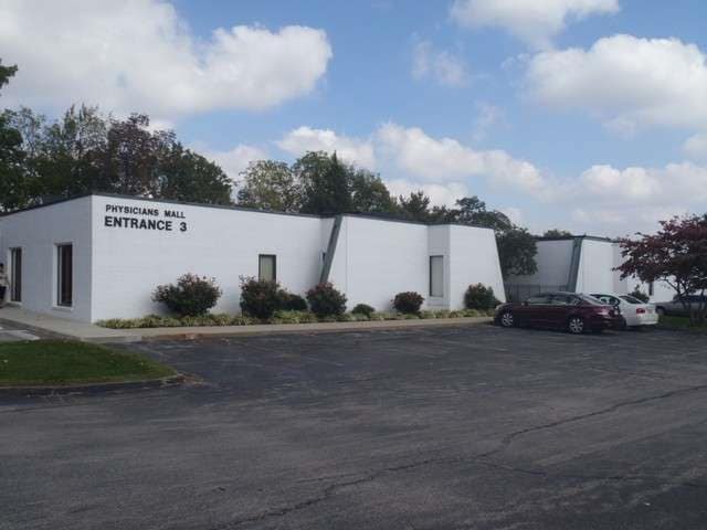
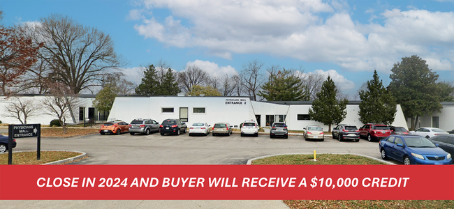
Property Record
715 Shaker Dr, Lexington, KY 40504
Property Detail
715 Shaker Dr
Officecondo
G-505 PHYSICIANS MALL LOT; BOOK: 124 PAGE: 265
P-1
FAYETTE
B and X Area of moderate flood hazard, usually the area between the limits of the 100-year and 500-year floods.
Kentucky
2025
West Lexington/Fayette
2025
Lexington/Fayette
002600
Lexington-Fayette, KY
800 SF
15024860
NEARBY LISTINGS FOR SALE OR LEASE
DEMOGRAPHICS near 715 Shaker Dr
1 mile
3 mile
5 mile
2025 Total Population
15,090
108,427
247,063
2030 Population
15,654
112,316
255,273
Pop Growth 2025-2030
+ 3.74%
+ 3.59%
+ 3.32%
Average Age
37
38
38
2025 Total Households
7,258
46,380
105,510
HH Growth 2025-2030
+ 3.95%
+ 4.01%
+ 3.60%
Median Household Inc
$49,628
$54,206
$62,271
Avg Household Size
2.00
2.10
2.20
2025 Avg HH Vehicles
2.00
2.00
2.00
Median Home Value
$256,873
$332,941
$285,949
Median Year Built
1968
1968
1978
Nearby Places
Map Layers
Map Styles
 Street
 Aerial
Layers
 Traffic
 Biking
Places
Listings with unknown addresses are not visible on the map
- Restaurants
- Banks
- Shops
- Fitness
- Groceries
PUBLIC TRANSPORTATION
AIRPORT
Blue Grass
Drive
Walk
Distance
Blue Grass
15 min
7.3 mi
Freight Ports
Port of Toledo
Drive
Walk
Distance
Port of Toledo
337 min
289.1 mi
SALE & LEASE HISTORY
LISTING DATE
SALE/LEASE

Nov 30, 2017
For Lease
Mar 08, 2018
For Lease
Feb 18, 2020
For Lease
Feb 18, 2020
For Sale
Dec 18, 2018
For Sale
Aug 05, 2017
For Sale
Aug 02, 2021
For Lease
Aug 02, 2021
For Sale
Aug 02, 2021
For Sale
Apr 10, 2024
For Sale
Nearby Properties
Address
Land Use
TOTAL SIZE
Lot Size
Zoning
Address
Land Use
TOTAL SIZE
Lot Size
Zoning
3,896 SF
0.49 AC
B-4
Address
Land Use
TOTAL SIZE
Lot Size
Zoning
635,961 SF
23.52 AC
P-1
Address
Land Use
TOTAL SIZE
Lot Size
Zoning
14.90 AC
B-2B
Address
Land Use
TOTAL SIZE
Lot Size
Zoning
510,633 SF
15.10 AC
P-1
Address
Land Use
TOTAL SIZE
Lot Size
Zoning
372,139 SF
4.82 AC
R-4
Address
Land Use
TOTAL SIZE
Lot Size
Zoning
87 SF
R-4
Address
Land Use
TOTAL SIZE
Lot Size
Zoning
Address
Land Use
TOTAL SIZE
Lot Size
Zoning
82.77 AC
R-4
Address
Land Use
TOTAL SIZE
Lot Size
Zoning
Address
Land Use
TOTAL SIZE
Lot Size
Zoning
582.34 AC
A-U
Address
Land Use
TOTAL SIZE
Lot Size
Zoning
319,500 SF
0.25 AC
P-1
Address
Land Use
TOTAL SIZE
Lot Size
Zoning
318,370 SF
17.79 AC
B-6P
Address
Land Use
TOTAL SIZE
Lot Size
Zoning
292,730 SF
3.18 AC
R-1C
Address
Land Use
TOTAL SIZE
Lot Size
Zoning
394,590 SF
14.76 AC
R-4
Address
Land Use
TOTAL SIZE
Lot Size
Zoning
263,090 SF
37.66 AC
A-U
Address
Land Use
TOTAL SIZE
Lot Size
Zoning
1.25 AC
B-2B
Address
Land Use
TOTAL SIZE
Lot Size
Zoning
156,270 SF
11.18 AC
R-1C
Address
Land Use
TOTAL SIZE
Lot Size
Zoning
29,480 SF
4.60 AC
MU-3
Address
Land Use
TOTAL SIZE
Lot Size
Zoning
134,783 SF
1.36 AC
B-1
Address
Land Use
TOTAL SIZE
Lot Size
Zoning
8,078 SF
10.61 AC
R-5
Address
Land Use
TOTAL SIZE
Lot Size
Zoning
26,672 SF
1.24 AC
B-1
Address
Land Use
TOTAL SIZE
Lot Size
Zoning
384,037 SF
9.52 AC
P-1
Address
Land Use
TOTAL SIZE
Lot Size
Zoning
2,545 SF
14 AC
R-4
Address
Land Use
TOTAL SIZE
Lot Size
Zoning
25,920 SF
23.71 AC
R-2
Address
Land Use
TOTAL SIZE
Lot Size
Zoning
9,774 SF
798.32 AC
A-R
Address
Land Use
TOTAL SIZE
Lot Size
Zoning
61,965 SF
46.96 AC
A-U
Address
Land Use
TOTAL SIZE
Lot Size
Zoning
8,880 SF
7.39 AC
R-4
Address
Land Use
TOTAL SIZE
Lot Size
Zoning
278,944 SF
0.75 AC
B-2B
Address
Land Use
TOTAL SIZE
Lot Size
Zoning
340,698 SF
B-2B
Address
Land Use
TOTAL SIZE
Lot Size
Zoning
0.42 AC
B-2B
The World's #1 Commercial Real Estate Marketplace
Connect with us
© 2026 CoStar Group
The information above has been obtained from sources believed reliable. While we do not doubt its accuracy we have not verified it and make no guarantee, warranty or representation about it. It is your responsibility to independently confirm its accuracy and completeness. Any projections, opinions, assumptions, or estimates used are for example only and do not represent the current or future performance of the property. The value of this transaction to you depends on tax and other factors which should be evaluated by your tax, financial, and legal advisors. You and your advisors should conduct a careful, independent investigation of the property to determine to your satisfaction the suitability of the property for your needs.