Property Record
715 W Pike Blvd, Weslaco, TX 78596
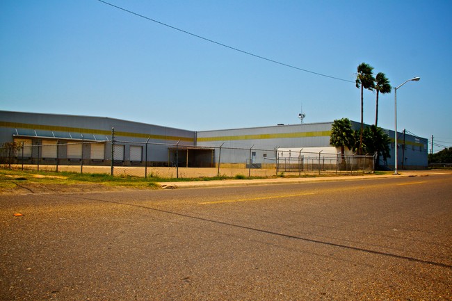


This Property Is For Sale
Current Lease Availabilities
Property Detail
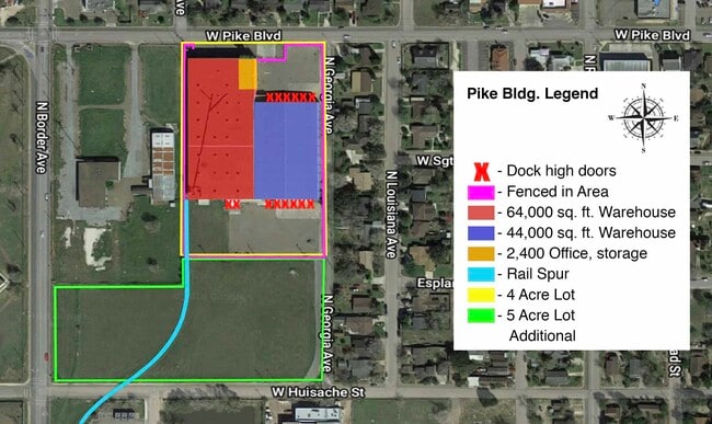
715 W Pike Blvd
McAllen-Edinburg-Mission, TX
PIKE-SNEAD ADDN LOTS 7-12 BLKS 2 & 5, ALL BLKS 3 & 4 ABND GEORGIA ST & CASA BLANCA ST & ABND ALLEY W-BLKS 3 & 4; LOTS 6-10 BLK 8; LOTS 1-5 BLK 9 & ABND ALLEY W LOTS 1-5 BLK 9 6.95AC NET
P6700-00-002-0007-00
Hidalgo
Commercialnec
Texas
2024
7
2025
6.95 AC
022401
Outlying Hidalgo County
108,876 SF
McAllen/Edinburg/Pharr
NEARBY LISTINGS FOR SALE OR LEASE
DEMOGRAPHICS near 715 W Pike Blvd
1 mile
3 mile
5 mile
2025 Total Population
12,356
66,649
118,411
2030 Population
13,075
70,890
125,482
Pop Growth 2025-2030
+ 5.82%
+ 6.36%
+ 5.97%
Average Age
37
37
36
2025 Total Households
4,095
21,318
35,971
HH Growth 2025-2030
+ 5.67%
+ 6.87%
+ 6.47%
Median Household Inc
$44,750
$54,168
$50,528
Avg Household Size
2.90
3.00
3.20
2025 Avg HH Vehicles
2.00
2.00
2.00
Median Home Value
$119,328
$126,128
$113,668
Median Year Built
1989
1996
1996
Nearby Places
Map Layers
Map Styles
 Street
 Aerial
Transit
 Traffic
 Biking
Places
Listings with unknown addresses are not visible on the map
- Restaurants
- Banks
- Shops
- Fitness
- Groceries
PUBLIC TRANSPORTATION
AIRPORT
McAllen International
Drive
Walk
Distance
McAllen International
23 min
16.8 mi
Valley International
Drive
Walk
Distance
Valley International
32 min
25.1 mi
Freight Ports
Port of Brownsville
Drive
Walk
Distance
Port of Brownsville
50 min
44.4 mi
Nearby Properties
Address
Land Use
TOTAL SIZE
Lot Size
Zoning
Address
Land Use
TOTAL SIZE
Lot Size
Zoning
401,046 SF
13.97 AC
Address
Land Use
TOTAL SIZE
Lot Size
Zoning
307,987 SF
39.11 AC
Address
Land Use
TOTAL SIZE
Lot Size
Zoning
415,762 SF
56.31 AC
CO
Address
Land Use
TOTAL SIZE
Lot Size
Zoning
258,111 SF
51.09 AC
Address
Land Use
TOTAL SIZE
Lot Size
Zoning
205,544 SF
20.48 AC
C
Address
Land Use
TOTAL SIZE
Lot Size
Zoning
113,449 SF
19.01 AC
Address
Land Use
TOTAL SIZE
Lot Size
Zoning
197,394 SF
14.28 AC
CO
Address
Land Use
TOTAL SIZE
Lot Size
Zoning
44,220 SF
107.38 AC
Address
Land Use
TOTAL SIZE
Lot Size
Zoning
2 SF
48.88 AC
GT
Address
Land Use
TOTAL SIZE
Lot Size
Zoning
109,578 SF
7.61 AC
Address
Land Use
TOTAL SIZE
Lot Size
Zoning
108,541 SF
16.50 AC
Address
Land Use
TOTAL SIZE
Lot Size
Zoning
5 SF
46.56 AC
GT
Address
Land Use
TOTAL SIZE
Lot Size
Zoning
79,517 SF
16.26 AC
Address
Land Use
TOTAL SIZE
Lot Size
Zoning
108.55 AC
MP
Address
Land Use
TOTAL SIZE
Lot Size
Zoning
76,552 SF
19.48 AC
CO
Address
Land Use
TOTAL SIZE
Lot Size
Zoning
28,768 SF
3.20 AC
Address
Land Use
TOTAL SIZE
Lot Size
Zoning
122,491 SF
28.72 AC
Address
Land Use
TOTAL SIZE
Lot Size
Zoning
137,414 SF
10 AC
Address
Land Use
TOTAL SIZE
Lot Size
Zoning
240,421 SF
22.59 AC
Address
Land Use
TOTAL SIZE
Lot Size
Zoning
4,174 SF
19.70 AC
Address
Land Use
TOTAL SIZE
Lot Size
Zoning
57,032 SF
1.82 AC
CO
Address
Land Use
TOTAL SIZE
Lot Size
Zoning
112,706 SF
10.13 AC
Address
Land Use
TOTAL SIZE
Lot Size
Zoning
135,639 SF
40 AC
Address
Land Use
TOTAL SIZE
Lot Size
Zoning
97,698 SF
10.73 AC
CO
Address
Land Use
TOTAL SIZE
Lot Size
Zoning
61,420 SF
5.01 AC
CO
Address
Land Use
TOTAL SIZE
Lot Size
Zoning
13 SF
29 AC
Address
Land Use
TOTAL SIZE
Lot Size
Zoning
49,538 SF
8 AC
Address
Land Use
TOTAL SIZE
Lot Size
Zoning
9 SF
15.24 AC
Address
Land Use
TOTAL SIZE
Lot Size
Zoning
63,469 SF
37.86 AC
CO
Address
Land Use
TOTAL SIZE
Lot Size
Zoning
70,035 SF
16.46 AC
The World's #1 Commercial Real Estate Marketplace
Connect with us
© 2026 CoStar Group
The information above has been obtained from sources believed reliable. While we do not doubt its accuracy we have not verified it and make no guarantee, warranty or representation about it. It is your responsibility to independently confirm its accuracy and completeness. Any projections, opinions, assumptions, or estimates used are for example only and do not represent the current or future performance of the property. The value of this transaction to you depends on tax and other factors which should be evaluated by your tax, financial, and legal advisors. You and your advisors should conduct a careful, independent investigation of the property to determine to your satisfaction the suitability of the property for your needs.