Property Record
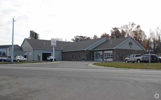
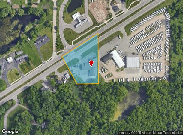
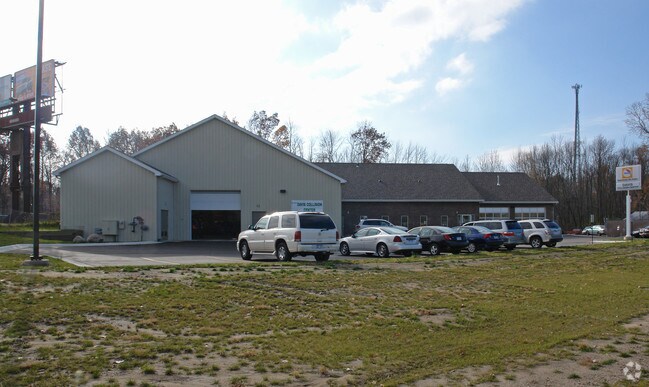
7150 E Saginaw St, Haslett, MI 48840
NEARBY LISTINGS FOR SALE OR LEASE
Property Detail
7150 E Saginaw St
010-034-300-145-00
Beg Sub
Autorepair
COM 1273.03 FT W OF S 1/4 COR SEC 34, T5N-R1W, TH W 207.46 FT, N 28 DEG W299.08 FT TO CL OF WEST BOUND TEMP I-69, TH N 57 DEG
X
Clinton
26065C0043D
Michigan
2024
2.57 AC
2025
East Lansing
011106
West Michigan
14,480 SF
Lansing-East Lansing, MI
DEMOGRAPHICS near 7150 E Saginaw St
1 Mile
3 Mile
5 Mile
2024 Total Population
3,300
29,913
87,209
2029 Population
3,301
29,932
87,138
Pop Growth 2024-2029
+ 0.03%
+ 0.06%
(0.08%)
Average Age
44
41
36
2024 Total Households
1,443
13,308
36,845
HH Growth 2024-2029
(0.21%)
+ 0.02%
(0.12%)
Median Household Inc
$73,999
$72,907
$58,540
Avg Household Size
2.20
2.20
2.20
2024 Avg HH Vehicles
2.00
2.00
2.00
Median Home Value
$331,101
$257,577
$252,106
Median Year Built
1985
1984
1981
Nearby Places
Map Layers
Map Styles
 Street
 Aerial
- Restaurants
- Banks
- Shops
- Fitness
- Groceries
PUBLIC TRANSPORTATION
COMMUTER RAIL
East Lansing Amtrak Station (Blue Water - Amtrak)
DRIVE
WALK
Distance
East Lansing Amtrak Station (Blue Water - Amtrak)
14 min
6.8 mi
AIRPORT
Capital Region International
DRIVE
WALK
Distance
Capital Region International
21 min
11.2 mi
Freight Ports
Port of Toledo
DRIVE
WALK
Distance
Port of Toledo
152 min
119.5 mi
Nearby Properties
Address
Land Use
TOTAL SIZE
Lot Size
Zoning
Address
Land Use
TOTAL SIZE
Lot Size
Zoning
149,799 SF
9.60 AC
Address
Land Use
TOTAL SIZE
Lot Size
Zoning
32,946 SF
64.40 AC
RD
Address
Land Use
TOTAL SIZE
Lot Size
Zoning
215,335 SF
38.10 AC
RM08
Address
Land Use
TOTAL SIZE
Lot Size
Zoning
9,280 SF
24.38 AC
RC
Address
Land Use
TOTAL SIZE
Lot Size
Zoning
3,504 SF
30.61 AC
DEVELOPMEN
Address
Land Use
TOTAL SIZE
Lot Size
Zoning
4,784 SF
24.06 AC
RC
Address
Land Use
TOTAL SIZE
Lot Size
Zoning
96,079 SF
14.99 AC
RA
Address
Land Use
TOTAL SIZE
Lot Size
Zoning
15,918 SF
23.13 AC
RC
Address
Land Use
TOTAL SIZE
Lot Size
Zoning
114,593 SF
26.07 AC
Address
Land Use
TOTAL SIZE
Lot Size
Zoning
158,696 SF
24.74 AC
DEVELOPMEN
Address
Land Use
TOTAL SIZE
Lot Size
Zoning
16,248 SF
9.57 AC
RC
Address
Land Use
TOTAL SIZE
Lot Size
Zoning
3,792 SF
34.73 AC
RD
Address
Land Use
TOTAL SIZE
Lot Size
Zoning
15,102 SF
19.59 AC
RC
Address
Land Use
TOTAL SIZE
Lot Size
Zoning
100,754 SF
23.79 AC
CS
Address
Land Use
TOTAL SIZE
Lot Size
Zoning
3,769 SF
6.38 AC
C-2
Address
Land Use
TOTAL SIZE
Lot Size
Zoning
11,014 SF
9.37 AC
DEVELOPMEN
Address
Land Use
TOTAL SIZE
Lot Size
Zoning
12,900 SF
5 AC
MDR
Address
Land Use
TOTAL SIZE
Lot Size
Zoning
56,636 SF
6.58 AC
RR
Address
Land Use
TOTAL SIZE
Lot Size
Zoning
15.60 AC
RM22
Address
Land Use
TOTAL SIZE
Lot Size
Zoning
26,646 SF
16.37 AC
DEVELOPMEN
Address
Land Use
TOTAL SIZE
Lot Size
Zoning
39,346 SF
5.63 AC
RA
Address
Land Use
TOTAL SIZE
Lot Size
Zoning
3,933 SF
19.24 AC
RC
Address
Land Use
TOTAL SIZE
Lot Size
Zoning
7,468 SF
6.90 AC
RC
Address
Land Use
TOTAL SIZE
Lot Size
Zoning
143,060 SF
20.01 AC
Address
Land Use
TOTAL SIZE
Lot Size
Zoning
2,812 SF
10.50 AC
RD
Address
Land Use
TOTAL SIZE
Lot Size
Zoning
3,687 SF
10.67 AC
RD
Address
Land Use
TOTAL SIZE
Lot Size
Zoning
3 AC
RM32
Address
Land Use
TOTAL SIZE
Lot Size
Zoning
36,806 SF
12.28 AC
HDD
Address
Land Use
TOTAL SIZE
Lot Size
Zoning
23,226 SF
5.25 AC
RC
Address
Land Use
TOTAL SIZE
Lot Size
Zoning
1,800 SF
5.09 AC
RC
The World's #1 Commercial Real Estate Marketplace
Connect with us
© 2026 CoStar Group
The information above has been obtained from sources believed reliable. While we do not doubt its accuracy we have not verified it and make no guarantee, warranty or representation about it. It is your responsibility to independently confirm its accuracy and completeness. Any projections, opinions, assumptions, or estimates used are for example only and do not represent the current or future performance of the property. The value of this transaction to you depends on tax and other factors which should be evaluated by your tax, financial, and legal advisors. You and your advisors should conduct a careful, independent investigation of the property to determine to your satisfaction the suitability of the property for your needs.