Property Record
7150 N 58Th Dr, Glendale, AZ 85301
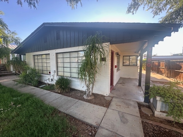
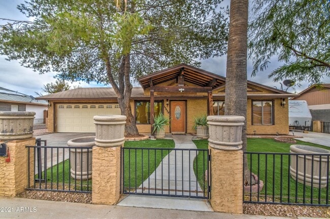
This Property Is For Sale
NEARBY LISTINGS FOR SALE OR LEASE
Property Detail
7150 N 58Th Dr
Phoenix-Mesa-Chandler, AZ
Glendale Amd Blocks 1-3 10-15
147-26-033B
GLENDALE AMD BLOCKS 1-3 10-15 MCR 2-49
Sfr
Maricopa
X
Arizona
04013C1720L
4
2025
0.16 AC
2025
Northwest Phoenix
092500
Phoenix
1,352 SF
DEMOGRAPHICS near 7150 N 58Th Dr
1 Mile
3 Mile
5 Mile
2024 Total Population
16,205
189,088
524,067
2029 Population
17,474
203,436
564,364
Pop Growth 2024-2029
+ 7.83%
+ 7.59%
+ 7.69%
Average Age
36
35
35
2024 Total Households
5,478
60,866
164,451
HH Growth 2024-2029
+ 7.90%
+ 7.69%
+ 7.93%
Median Household Inc
$42,864
$51,899
$55,404
Avg Household Size
2.80
3.00
3.00
2024 Avg HH Vehicles
2.00
2.00
2.00
Median Home Value
$212,117
$251,765
$258,545
Median Year Built
1971
1977
1977
Nearby Places
Map Layers
Map Styles
 Street
 Aerial
- Restaurants
- Banks
- Shops
- Fitness
- Groceries
PUBLIC TRANSPORTATION
AIRPORT
Phoenix Sky Harbor International
DRIVE
WALK
Distance
Phoenix Sky Harbor International
26 min
15.4 mi
Freight Ports
Port of San Diego
DRIVE
WALK
Distance
Port of San Diego
397 min
353.6 mi
Nearby Properties
Address
Land Use
TOTAL SIZE
Lot Size
Zoning
Address
Land Use
TOTAL SIZE
Lot Size
Zoning
Address
Land Use
TOTAL SIZE
Lot Size
Zoning
611,971 SF
36.16 AC
A1
Address
Land Use
TOTAL SIZE
Lot Size
Zoning
281,038 SF
7.71 AC
Address
Land Use
TOTAL SIZE
Lot Size
Zoning
285,815 SF
37.17 AC
R-6
Address
Land Use
TOTAL SIZE
Lot Size
Zoning
926 SF
37.32 AC
I-1
Address
Land Use
TOTAL SIZE
Lot Size
Zoning
629,928 SF
41.37 AC
Address
Land Use
TOTAL SIZE
Lot Size
Zoning
276,102 SF
39.72 AC
AG
Address
Land Use
TOTAL SIZE
Lot Size
Zoning
25.91 AC
A1
Address
Land Use
TOTAL SIZE
Lot Size
Zoning
310,295 SF
9.32 AC
Address
Land Use
TOTAL SIZE
Lot Size
Zoning
262,609 SF
18.96 AC
I-1
Address
Land Use
TOTAL SIZE
Lot Size
Zoning
200,998 SF
0.06 AC
C-C
Address
Land Use
TOTAL SIZE
Lot Size
Zoning
187,309 SF
19.99 AC
R-6
Address
Land Use
TOTAL SIZE
Lot Size
Zoning
88,059 SF
78.03 AC
AG
Address
Land Use
TOTAL SIZE
Lot Size
Zoning
217,214 SF
27.12 AC
R-6
Address
Land Use
TOTAL SIZE
Lot Size
Zoning
196,254 SF
17.36 AC
R2
Address
Land Use
TOTAL SIZE
Lot Size
Zoning
131,380 SF
25.55 AC
R-6
Address
Land Use
TOTAL SIZE
Lot Size
Zoning
97,509 SF
10.74 AC
AG
Address
Land Use
TOTAL SIZE
Lot Size
Zoning
90,148 SF
6.13 AC
R-6
Address
Land Use
TOTAL SIZE
Lot Size
Zoning
206,709 SF
11.76 AC
Address
Land Use
TOTAL SIZE
Lot Size
Zoning
95,025 SF
13.59 AC
R1-6
Address
Land Use
TOTAL SIZE
Lot Size
Zoning
2.23 AC
Address
Land Use
TOTAL SIZE
Lot Size
Zoning
287,199 SF
15.11 AC
M-H
Address
Land Use
TOTAL SIZE
Lot Size
Zoning
134,215 SF
17.75 AC
R-6
Address
Land Use
TOTAL SIZE
Lot Size
Zoning
116,276 SF
11.58 AC
R-6
Address
Land Use
TOTAL SIZE
Lot Size
Zoning
Address
Land Use
TOTAL SIZE
Lot Size
Zoning
320,093 SF
14.56 AC
M-H
Address
Land Use
TOTAL SIZE
Lot Size
Zoning
94,663 SF
19.32 AC
R-6
Address
Land Use
TOTAL SIZE
Lot Size
Zoning
153,190 SF
24.67 AC
AG
Address
Land Use
TOTAL SIZE
Lot Size
Zoning
113,313 SF
9.49 AC
R-6
Address
Land Use
TOTAL SIZE
Lot Size
Zoning
212,109 SF
20.14 AC
C-C
The World's #1 Commercial Real Estate Marketplace
Connect with us
© 2026 CoStar Group
The information above has been obtained from sources believed reliable. While we do not doubt its accuracy we have not verified it and make no guarantee, warranty or representation about it. It is your responsibility to independently confirm its accuracy and completeness. Any projections, opinions, assumptions, or estimates used are for example only and do not represent the current or future performance of the property. The value of this transaction to you depends on tax and other factors which should be evaluated by your tax, financial, and legal advisors. You and your advisors should conduct a careful, independent investigation of the property to determine to your satisfaction the suitability of the property for your needs.