Property Record
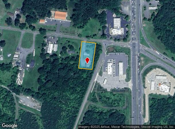
7155 Opal Rd, Warrenton, VA 20186

NEARBY LISTINGS FOR SALE OR LEASE
-
-
View all Warrenton listings for sale on LoopNet.com
Property Detail
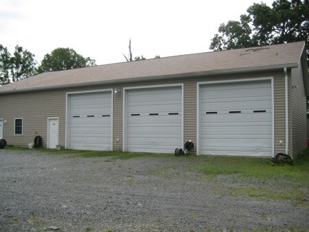
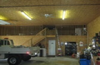
7155 Opal Rd
Washington-Arlington-Alexandria, DC-VA-MD-WV
John Boldridge
6980-29-1893
LOT 1
Commercialofficeresidentialmixeduse
Fauquier
X
Virginia
51061C0410D
1
2025
1 AC
2025
Fauquier County/Vint Hill
930206
Washington, DC
1,125 SF
DEMOGRAPHICS near 7155 Opal Rd
1 Mile
3 Mile
5 Mile
2024 Total Population
656
5,280
14,732
2029 Population
687
5,564
15,495
Pop Growth 2024-2029
+ 4.73%
+ 5.38%
+ 5.18%
Average Age
42
40
39
2024 Total Households
233
1,863
5,111
HH Growth 2024-2029
+ 4.72%
+ 5.48%
+ 5.26%
Median Household Inc
$103,879
$102,237
$98,372
Avg Household Size
2.80
2.80
2.80
2024 Avg HH Vehicles
3.00
3.00
3.00
Median Home Value
$448,648
$402,356
$398,013
Median Year Built
1984
1986
1987
Nearby Places
Map Layers
Map Styles
 Street
 Aerial
- Restaurants
- Banks
- Shops
- Fitness
- Groceries
PUBLIC TRANSPORTATION
AIRPORT
Washington Dulles International
DRIVE
WALK
Distance
Washington Dulles International
63 min
41.1 mi
Freight Ports
Port of Baltimore
DRIVE
WALK
Distance
Port of Baltimore
122 min
91.5 mi
Nearby Properties
Address
Land Use
TOTAL SIZE
Lot Size
Zoning
Address
Land Use
TOTAL SIZE
Lot Size
Zoning
69,568 SF
98.58 AC
AGRICULTUR
Address
Land Use
TOTAL SIZE
Lot Size
Zoning
90,294 SF
3.58 AC
MUBEALETON
Address
Land Use
TOTAL SIZE
Lot Size
Zoning
1,344 SF
38.28 AC
COMMERCIAL
Address
Land Use
TOTAL SIZE
Lot Size
Zoning
5,494 SF
3.41 AC
COMMERCIAL
Address
Land Use
TOTAL SIZE
Lot Size
Zoning
2,736 SF
168.03 AC
AGRICULTUR
Address
Land Use
TOTAL SIZE
Lot Size
Zoning
852 SF
11.57 AC
COMMERCIAL
Address
Land Use
TOTAL SIZE
Lot Size
Zoning
4,800 SF
4.38 AC
COMMERCIAL
Address
Land Use
TOTAL SIZE
Lot Size
Zoning
6,808 SF
2.30 AC
INDUSTRIAL
Address
Land Use
TOTAL SIZE
Lot Size
Zoning
8,850 SF
8.20 AC
COMMERCIAL
Address
Land Use
TOTAL SIZE
Lot Size
Zoning
235.05 AC
PLANNED RE
Address
Land Use
TOTAL SIZE
Lot Size
Zoning
1,712 SF
2.05 AC
COMMERCIAL
Address
Land Use
TOTAL SIZE
Lot Size
Zoning
5,264 SF
2.42 AC
COMMERCIAL
Address
Land Use
TOTAL SIZE
Lot Size
Zoning
1,800 SF
15.85 AC
COMMERCIAL
Address
Land Use
TOTAL SIZE
Lot Size
Zoning
11,656 SF
6 AC
INDUSTRIAL
Address
Land Use
TOTAL SIZE
Lot Size
Zoning
7,000 SF
6 AC
COMMERCIAL
Address
Land Use
TOTAL SIZE
Lot Size
Zoning
3,610 SF
2.98 AC
COMMERCIAL
Address
Land Use
TOTAL SIZE
Lot Size
Zoning
2,616 SF
10.10 AC
RES 1 DWEL
Address
Land Use
TOTAL SIZE
Lot Size
Zoning
47.40 AC
AGRICULTUR
Address
Land Use
TOTAL SIZE
Lot Size
Zoning
11,000 SF
5.83 AC
INDUSTRIAL
Address
Land Use
TOTAL SIZE
Lot Size
Zoning
6,697 SF
5.23 AC
INDUSTRIAL
Address
Land Use
TOTAL SIZE
Lot Size
Zoning
17,050 SF
2.96 AC
INDUSTRIAL
Address
Land Use
TOTAL SIZE
Lot Size
Zoning
14,720 SF
3.81 AC
INDUSTRIAL
Address
Land Use
TOTAL SIZE
Lot Size
Zoning
5,600 SF
3.48 AC
INDUSTRIAL
Address
Land Use
TOTAL SIZE
Lot Size
Zoning
2,356 SF
0.96 AC
MUBEALETON
Address
Land Use
TOTAL SIZE
Lot Size
Zoning
6,108 SF
4.68 AC
AGRICULTUR
Address
Land Use
TOTAL SIZE
Lot Size
Zoning
5.10 AC
INDUSTRIAL
The World's #1 Commercial Real Estate Marketplace
Connect with us
© 2026 CoStar Group
The information above has been obtained from sources believed reliable. While we do not doubt its accuracy we have not verified it and make no guarantee, warranty or representation about it. It is your responsibility to independently confirm its accuracy and completeness. Any projections, opinions, assumptions, or estimates used are for example only and do not represent the current or future performance of the property. The value of this transaction to you depends on tax and other factors which should be evaluated by your tax, financial, and legal advisors. You and your advisors should conduct a careful, independent investigation of the property to determine to your satisfaction the suitability of the property for your needs.