Property Record
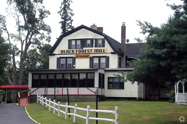
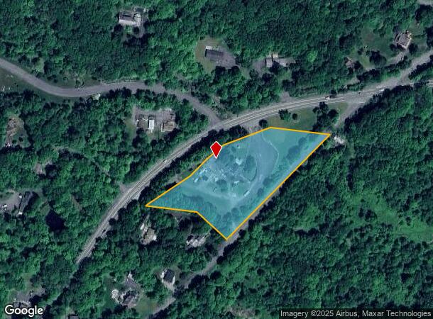
716 State Route 32, Highland Mills, NY 10930
NEARBY LISTINGS FOR SALE OR LEASE
-
-
View all Highland Mills listings for sale on LoopNet.com
Property Detail
716 State Route 32
335809-207-000-0001-008.000-0000
Orange
Restaurantbuilding
New York
X
8.000
36071C0501E
3.60 AC
2024
Newburgh
2024
Northern New Jersey
013500
New York-Jersey City-White Plains, NY-NJ
11,899 SF
DEMOGRAPHICS near 716 State Route 32
1 Mile
3 Mile
5 Mile
2024 Total Population
5,203
35,906
74,128
2029 Population
5,304
37,056
76,134
Pop Growth 2024-2029
+ 1.94%
+ 3.20%
+ 2.71%
Average Age
38
28
29
2024 Total Households
1,709
8,667
18,779
HH Growth 2024-2029
+ 1.81%
+ 3.37%
+ 2.79%
Median Household Inc
$127,778
$77,445
$82,827
Avg Household Size
2.90
4.00
3.80
2024 Avg HH Vehicles
2.00
1.00
2.00
Median Home Value
$330,082
$407,749
$388,142
Median Year Built
1985
1992
1987
Nearby Places
Map Layers
Map Styles
 Street
 Aerial
- Restaurants
- Banks
- Shops
- Fitness
- Groceries
PUBLIC TRANSPORTATION
COMMUTER RAIL
Harriman (Bergen County/Port Jervis Line - NJ Transit Commuter Rail (NJ Transit), Main/Port Jervis Line - NJ Transit Commuter Rail (NJ Transit))
DRIVE
WALK
Distance
Harriman (Bergen County/Port Jervis Line - NJ Transit Commuter Rail (NJ Transit), Main/Port Jervis Line - NJ Transit Commuter Rail (NJ Transit))
13 min
5.7 mi
Salisbury Mills Cornwall (Bergen County/Port Jervis Line - NJ Transit Commuter Rail (NJ Transit), Main/Port Jervis Line - NJ Transit Commuter Rail (NJ Transit))
DRIVE
WALK
Distance
Salisbury Mills Cornwall (Bergen County/Port Jervis Line - NJ Transit Commuter Rail (NJ Transit), Main/Port Jervis Line - NJ Transit Commuter Rail (NJ Transit))
17 min
8.5 mi
AIRPORT
New York Stewart International
DRIVE
WALK
Distance
New York Stewart International
22 min
13.3 mi
Westchester County
DRIVE
WALK
Distance
Westchester County
67 min
48.1 mi
Freight Ports
Port Newark Container Terminal
DRIVE
WALK
Distance
Port Newark Container Terminal
79 min
55.4 mi
SALE & LEASE HISTORY
LISTING DATE
SALE/LEASE

Nov 21, 2019
For Sale
May 27, 2019
For Sale
Jan 28, 2020
For Sale
Nearby Properties
Address
Land Use
TOTAL SIZE
Lot Size
Zoning
Address
Land Use
TOTAL SIZE
Lot Size
Zoning
143.60 AC
LIO
Address
Land Use
TOTAL SIZE
Lot Size
Zoning
114.40 AC
Address
Land Use
TOTAL SIZE
Lot Size
Zoning
Address
Land Use
TOTAL SIZE
Lot Size
Zoning
7.30 AC
LIO
Address
Land Use
TOTAL SIZE
Lot Size
Zoning
Address
Land Use
TOTAL SIZE
Lot Size
Zoning
31,507 SF
10.50 AC
UR-M
Address
Land Use
TOTAL SIZE
Lot Size
Zoning
7.50 AC
RQTRA
Address
Land Use
TOTAL SIZE
Lot Size
Zoning
23,534 SF
6.60 AC
PD
Address
Land Use
TOTAL SIZE
Lot Size
Zoning
Address
Land Use
TOTAL SIZE
Lot Size
Zoning
1,476 SF
946.79 AC
R3A
Address
Land Use
TOTAL SIZE
Lot Size
Zoning
88,240 SF
3.02 AC
R-1
Address
Land Use
TOTAL SIZE
Lot Size
Zoning
92,868 SF
1.22 AC
PD
Address
Land Use
TOTAL SIZE
Lot Size
Zoning
126,112 SF
3.30 AC
R-1
Address
Land Use
TOTAL SIZE
Lot Size
Zoning
16.80 AC
Address
Land Use
TOTAL SIZE
Lot Size
Zoning
117,855 SF
3.20 AC
PD
Address
Land Use
TOTAL SIZE
Lot Size
Zoning
55,780 SF
64 AC
Address
Land Use
TOTAL SIZE
Lot Size
Zoning
132,928 SF
2.60 AC
PD
Address
Land Use
TOTAL SIZE
Lot Size
Zoning
114,667 SF
22.50 AC
PD
Address
Land Use
TOTAL SIZE
Lot Size
Zoning
9.60 AC
Address
Land Use
TOTAL SIZE
Lot Size
Zoning
105,554 SF
2.90 AC
R-1
Address
Land Use
TOTAL SIZE
Lot Size
Zoning
14.40 AC
Address
Land Use
TOTAL SIZE
Lot Size
Zoning
60.70 AC
Address
Land Use
TOTAL SIZE
Lot Size
Zoning
Address
Land Use
TOTAL SIZE
Lot Size
Zoning
107,305 SF
2.80 AC
PD
Address
Land Use
TOTAL SIZE
Lot Size
Zoning
94,006 SF
3.10 AC
R-2
Address
Land Use
TOTAL SIZE
Lot Size
Zoning
117.60 AC
Address
Land Use
TOTAL SIZE
Lot Size
Zoning
Address
Land Use
TOTAL SIZE
Lot Size
Zoning
31,224 SF
0.61 AC
R-1
Address
Land Use
TOTAL SIZE
Lot Size
Zoning
11.90 AC
IB
Address
Land Use
TOTAL SIZE
Lot Size
Zoning
45,900 SF
5.90 AC
LIO
The World's #1 Commercial Real Estate Marketplace
Connect with us
© 2025 CoStar Group
The information above has been obtained from sources believed reliable. While we do not doubt its accuracy we have not verified it and make no guarantee, warranty or representation about it. It is your responsibility to independently confirm its accuracy and completeness. Any projections, opinions, assumptions, or estimates used are for example only and do not represent the current or future performance of the property. The value of this transaction to you depends on tax and other factors which should be evaluated by your tax, financial, and legal advisors. You and your advisors should conduct a careful, independent investigation of the property to determine to your satisfaction the suitability of the property for your needs.