Property Record
7164 Kaw Dr, Kansas City, KS 66111
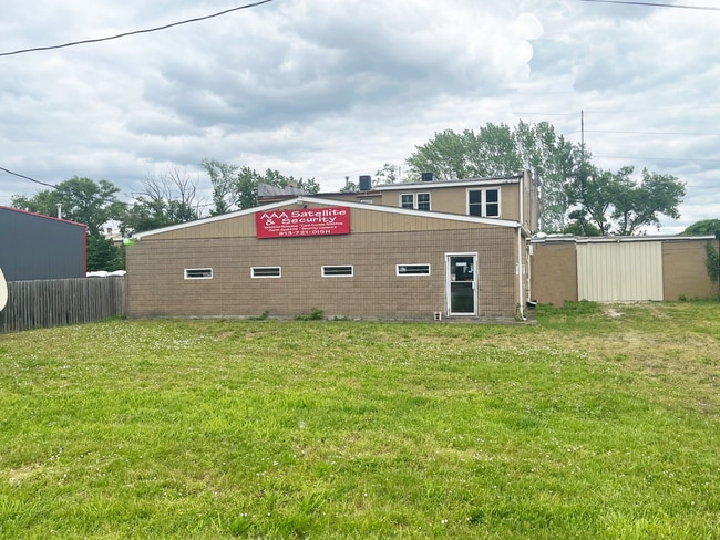

This Property Is For Sale
NEARBY LISTINGS FOR SALE OR LEASE
Property Detail
7164 Kaw Dr
926833
9268, S21, T11, R24, ACRES 0.23, BEG 635FT M/L W & 455FT M/L N OF SE COR NE1/4; S57W-82.9FT, N33W-118.8FT, NELY-82.1FT, S33E-128.9FT TO POB CONTG 0.23AC M/L
Storemultistory
Wyandotte
X
Kansas
20209C0153D
33
2025
0.23 AC
2025
Kansas City KS
044002
Kansas City
4,602 SF
Kansas City, MO-KS
DEMOGRAPHICS near 7164 Kaw Dr
1 Mile
3 Mile
5 Mile
2024 Total Population
2,766
22,549
102,522
2029 Population
2,616
22,032
101,125
Pop Growth 2024-2029
(5.42%)
(2.29%)
(1.36%)
Average Age
38
39
39
2024 Total Households
1,131
8,647
38,300
HH Growth 2024-2029
(5.66%)
(2.32%)
(1.25%)
Median Household Inc
$50,159
$59,111
$63,899
Avg Household Size
2.40
2.50
2.60
2024 Avg HH Vehicles
2.00
2.00
2.00
Median Home Value
$99,293
$158,593
$171,592
Median Year Built
1977
1969
1966
Nearby Places
Map Layers
Map Styles
 Street
 Aerial
- Restaurants
- Banks
- Shops
- Fitness
- Groceries
PUBLIC TRANSPORTATION
AIRPORT
Kansas City International
DRIVE
WALK
Distance
Kansas City International
32 min
23.9 mi
Nearby Properties
Address
Land Use
TOTAL SIZE
Lot Size
Zoning
Address
Land Use
TOTAL SIZE
Lot Size
Zoning
872,064 SF
119.39 AC
Address
Land Use
TOTAL SIZE
Lot Size
Zoning
542,696 SF
28.12 AC
Address
Land Use
TOTAL SIZE
Lot Size
Zoning
309,440 SF
120.73 AC
KR1
Address
Land Use
TOTAL SIZE
Lot Size
Zoning
249,363 SF
58.59 AC
Address
Land Use
TOTAL SIZE
Lot Size
Zoning
346,224 SF
28.44 AC
Address
Land Use
TOTAL SIZE
Lot Size
Zoning
407,936 SF
37.46 AC
1
Address
Land Use
TOTAL SIZE
Lot Size
Zoning
396,532 SF
31.98 AC
Address
Land Use
TOTAL SIZE
Lot Size
Zoning
241,816 SF
20.03 AC
Address
Land Use
TOTAL SIZE
Lot Size
Zoning
100,090 SF
48.47 AC
KR1
Address
Land Use
TOTAL SIZE
Lot Size
Zoning
383,232 SF
15.93 AC
LU1
Address
Land Use
TOTAL SIZE
Lot Size
Zoning
158,011 SF
26.66 AC
Address
Land Use
TOTAL SIZE
Lot Size
Zoning
62,452 SF
14.89 AC
KR1
Address
Land Use
TOTAL SIZE
Lot Size
Zoning
19,392 SF
2.77 AC
KCP1
Address
Land Use
TOTAL SIZE
Lot Size
Zoning
164,462 SF
23.15 AC
Address
Land Use
TOTAL SIZE
Lot Size
Zoning
43,922 SF
5.81 AC
Address
Land Use
TOTAL SIZE
Lot Size
Zoning
512,620 SF
23.85 AC
KM3
Address
Land Use
TOTAL SIZE
Lot Size
Zoning
13,925 SF
107.85 AC
KR1
Address
Land Use
TOTAL SIZE
Lot Size
Zoning
14,120 SF
2.95 AC
Address
Land Use
TOTAL SIZE
Lot Size
Zoning
50,006 SF
18.98 AC
KR1
Address
Land Use
TOTAL SIZE
Lot Size
Zoning
27,022 SF
11.66 AC
K99
Address
Land Use
TOTAL SIZE
Lot Size
Zoning
167,713 SF
78.95 AC
KR1
Address
Land Use
TOTAL SIZE
Lot Size
Zoning
15,264 SF
73.01 AC
KR1
Address
Land Use
TOTAL SIZE
Lot Size
Zoning
39,221 SF
10.44 AC
Address
Land Use
TOTAL SIZE
Lot Size
Zoning
43,445 SF
8.17 AC
KR1
Address
Land Use
TOTAL SIZE
Lot Size
Zoning
120,863 SF
8.36 AC
KCP1
Address
Land Use
TOTAL SIZE
Lot Size
Zoning
181,708 SF
20.29 AC
KR1
Address
Land Use
TOTAL SIZE
Lot Size
Zoning
13,673 SF
4.81 AC
Address
Land Use
TOTAL SIZE
Lot Size
Zoning
14,700 SF
1.75 AC
Address
Land Use
TOTAL SIZE
Lot Size
Zoning
37,244 SF
9.08 AC
KR1
Address
Land Use
TOTAL SIZE
Lot Size
Zoning
382,098 SF
14.97 AC
LU1
The World's #1 Commercial Real Estate Marketplace
Connect with us
© 2025 CoStar Group
The information above has been obtained from sources believed reliable. While we do not doubt its accuracy we have not verified it and make no guarantee, warranty or representation about it. It is your responsibility to independently confirm its accuracy and completeness. Any projections, opinions, assumptions, or estimates used are for example only and do not represent the current or future performance of the property. The value of this transaction to you depends on tax and other factors which should be evaluated by your tax, financial, and legal advisors. You and your advisors should conduct a careful, independent investigation of the property to determine to your satisfaction the suitability of the property for your needs.