Property Record
7167 Magnolia Ave, Riverside, CA 92504


NEARBY LISTINGS FOR SALE OR LEASE
Property Detail
7167 Magnolia Ave
Riverside-San Bernardino-Ontario, CA
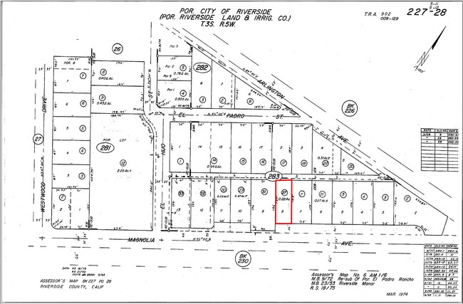
Assessors Map 6
227-283-027
.22 ACRES M/L IN LOT 8 AM 001/006 ASSESSORS MAP 6
Officebuilding
Riverside
X
California
06065C0710H
8
2024
0.22 AC
2025
Riverside
031402
Inland Empire (California)
2,280 SF
DEMOGRAPHICS near 7167 Magnolia Ave
1 mile
3 mile
5 mile
2024 Total Population
19,858
106,707
285,874
2029 Population
20,959
112,271
300,622
Pop Growth 2024-2029
+ 5.54%
+ 5.21%
+ 5.16%
Average Age
37
37
36
2024 Total Households
6,416
32,861
84,371
HH Growth 2024-2029
+ 5.08%
+ 4.77%
+ 4.76%
Median Household Inc
$73,119
$79,530
$76,818
Avg Household Size
2.90
3.00
3.10
2024 Avg HH Vehicles
2.00
2.00
2.00
Median Home Value
$406,235
$454,068
$464,870
Median Year Built
1960
1964
1974
Nearby Places
Map Layers
Map Styles
 Street
 Aerial
Transit
 Traffic
 Biking
Places
Listings with unknown addresses are not visible on the map
- Restaurants
- Banks
- Shops
- Fitness
- Groceries
PUBLIC TRANSPORTATION
COMMUTER RAIL
Riverside-Downtown (91 Line - Southern California Regional Rail Authority (Metrolink), Inland Empire-Orange County Line - Southern California Regional Rail Authority (Metrolink), Riverside Line - Southern California Regional Rail Authority (Metrolink))
Drive
Walk
Distance
Riverside-Downtown (91 Line - Southern California Regional Rail Authority (Metrolink), Inland Empire-Orange County Line - Southern California Regional Rail Authority (Metrolink), Riverside Line - Southern California Regional Rail Authority (Metrolink))
8 min
4.1 mi
Pedley (Riverside Line - Southern California Regional Rail Authority (Metrolink))
Drive
Walk
Distance
Pedley (Riverside Line - Southern California Regional Rail Authority (Metrolink))
12 min
5.9 mi
AIRPORT
Ontario International
Drive
Walk
Distance
Ontario International
27 min
16.8 mi
John Wayne/Orange County
Drive
Walk
Distance
John Wayne/Orange County
49 min
39.7 mi
Freight Ports
Port of Long Beach
Drive
Walk
Distance
Port of Long Beach
70 min
53.7 mi
SALE & LEASE HISTORY
LISTING DATE
SALE/LEASE

Sep 25, 2016
For Lease
May 21, 2024
For Sale
Feb 28, 2017
For Lease
Nearby Properties
Address
Land Use
TOTAL SIZE
Lot Size
Zoning
Address
Land Use
TOTAL SIZE
Lot Size
Zoning
412,950 SF
23.16 AC
C2
Address
Land Use
TOTAL SIZE
Lot Size
Zoning
247,416 SF
10.17 AC
Address
Land Use
TOTAL SIZE
Lot Size
Zoning
154,680 SF
3.13 AC
R1
Address
Land Use
TOTAL SIZE
Lot Size
Zoning
32,830 SF
6.66 AC
Address
Land Use
TOTAL SIZE
Lot Size
Zoning
169,980 SF
10.51 AC
C3
Address
Land Use
TOTAL SIZE
Lot Size
Zoning
43,152 SF
6.76 AC
R3S2
Address
Land Use
TOTAL SIZE
Lot Size
Zoning
37,729 SF
3.23 AC
Address
Land Use
TOTAL SIZE
Lot Size
Zoning
87,600 SF
0.39 AC
Address
Land Use
TOTAL SIZE
Lot Size
Zoning
129,739 SF
5.08 AC
Address
Land Use
TOTAL SIZE
Lot Size
Zoning
249,729 SF
15.60 AC
R3
Address
Land Use
TOTAL SIZE
Lot Size
Zoning
179,589 SF
18.62 AC
Address
Land Use
TOTAL SIZE
Lot Size
Zoning
157,112 SF
10.83 AC
Address
Land Use
TOTAL SIZE
Lot Size
Zoning
8.75 AC
R1065
Address
Land Use
TOTAL SIZE
Lot Size
Zoning
14,068 SF
6.61 AC
R3
Address
Land Use
TOTAL SIZE
Lot Size
Zoning
127,770 SF
12.94 AC
Address
Land Use
TOTAL SIZE
Lot Size
Zoning
163,325 SF
6.42 AC
R1
Address
Land Use
TOTAL SIZE
Lot Size
Zoning
483,726 SF
3.47 AC
C2
Address
Land Use
TOTAL SIZE
Lot Size
Zoning
446,832 SF
5.03 AC
Address
Land Use
TOTAL SIZE
Lot Size
Zoning
110,680 SF
11.88 AC
MP
Address
Land Use
TOTAL SIZE
Lot Size
Zoning
125,169 SF
5 AC
C1
Address
Land Use
TOTAL SIZE
Lot Size
Zoning
83,572 SF
2.93 AC
Address
Land Use
TOTAL SIZE
Lot Size
Zoning
18,480 SF
7.19 AC
Address
Land Use
TOTAL SIZE
Lot Size
Zoning
156,688 SF
6.09 AC
BMP
Address
Land Use
TOTAL SIZE
Lot Size
Zoning
40,024 SF
4.84 AC
Address
Land Use
TOTAL SIZE
Lot Size
Zoning
54,130 SF
6.46 AC
Address
Land Use
TOTAL SIZE
Lot Size
Zoning
77,640 SF
10.11 AC
R1065
Address
Land Use
TOTAL SIZE
Lot Size
Zoning
54,046 SF
3.05 AC
The World's #1 Commercial Real Estate Marketplace
Connect with us
© 2026 CoStar Group
The information above has been obtained from sources believed reliable. While we do not doubt its accuracy we have not verified it and make no guarantee, warranty or representation about it. It is your responsibility to independently confirm its accuracy and completeness. Any projections, opinions, assumptions, or estimates used are for example only and do not represent the current or future performance of the property. The value of this transaction to you depends on tax and other factors which should be evaluated by your tax, financial, and legal advisors. You and your advisors should conduct a careful, independent investigation of the property to determine to your satisfaction the suitability of the property for your needs.