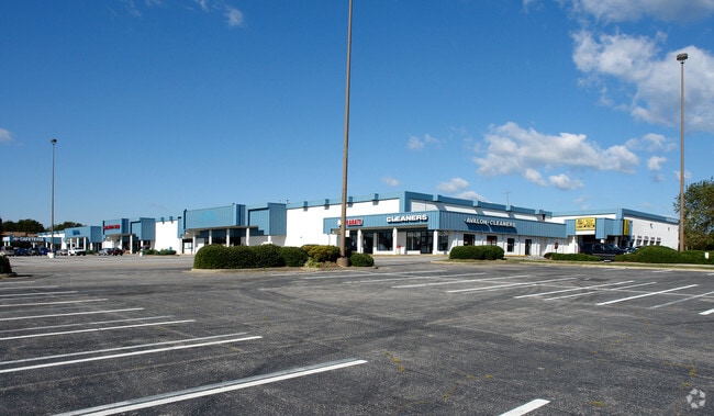
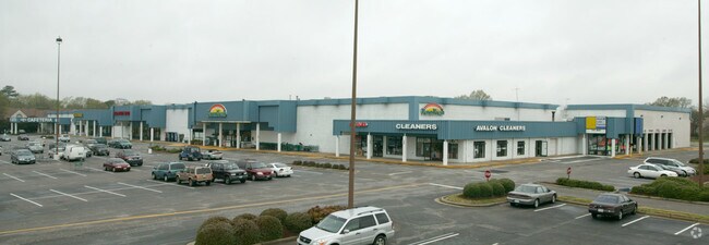
Property Record
737 Independence Blvd, Virginia Beach, VA 23455

NEARBY LISTINGS FOR SALE OR LEASE
Property Detail
737 Independence Blvd
Virginia Beach-Norfolk-Newport News, VA-NC
Lynnhaven
1478-52-1709
LYNNHAVEN PARCEL B 3.456 AC. BY PLAT
Commercialacreage
Virginia Beach
X
Virginia
5155310082G
00b00
2024
3.46 AC
2025
Pembroke
041200
Hampton Roads
98,760 SF
DEMOGRAPHICS near 737 Independence Blvd
1 Mile
3 Mile
5 Mile
2024 Total Population
12,948
109,943
242,597
2029 Population
12,821
109,007
240,134
Pop Growth 2024-2029
(0.98%)
(0.85%)
(1.02%)
Average Age
41
39
40
2024 Total Households
5,035
44,052
96,707
HH Growth 2024-2029
(1.11%)
(1.00%)
(1.15%)
Median Household Inc
$74,345
$71,039
$75,005
Avg Household Size
2.50
2.40
2.40
2024 Avg HH Vehicles
2.00
2.00
2.00
Median Home Value
$273,125
$291,265
$294,066
Median Year Built
1967
1980
1978
Nearby Places
Map Layers
Map Styles
 Street
 Aerial
- Restaurants
- Banks
- Shops
- Fitness
- Groceries
PUBLIC TRANSPORTATION
COMMUTER RAIL
Norfolk (Northeast Regional - Amtrak)
DRIVE
WALK
Distance
Norfolk (Northeast Regional - Amtrak)
13 min
9.4 mi
AIRPORT
Norfolk International
DRIVE
WALK
Distance
Norfolk International
16 min
7.5 mi
Newport News/Williamsburg International
DRIVE
WALK
Distance
Newport News/Williamsburg International
49 min
32.3 mi
Freight Ports
Virginia Port Authority - Portsmouth
DRIVE
WALK
Distance
Virginia Port Authority - Portsmouth
26 min
14.8 mi
Nearby Properties
Address
Land Use
TOTAL SIZE
Lot Size
Zoning
Address
Land Use
TOTAL SIZE
Lot Size
Zoning
697,880 SF
200.35 AC
R15
Address
Land Use
TOTAL SIZE
Lot Size
Zoning
1 SF
42.35 AC
A18
Address
Land Use
TOTAL SIZE
Lot Size
Zoning
1 SF
24.56 AC
A18
Address
Land Use
TOTAL SIZE
Lot Size
Zoning
15.92 AC
A18
Address
Land Use
TOTAL SIZE
Lot Size
Zoning
15.12 AC
Address
Land Use
TOTAL SIZE
Lot Size
Zoning
9.62 AC
A36
Address
Land Use
TOTAL SIZE
Lot Size
Zoning
226,775 SF
13.14 AC
B2
Address
Land Use
TOTAL SIZE
Lot Size
Zoning
7.45 AC
B4
Address
Land Use
TOTAL SIZE
Lot Size
Zoning
18.61 AC
PDH2
Address
Land Use
TOTAL SIZE
Lot Size
Zoning
Address
Land Use
TOTAL SIZE
Lot Size
Zoning
301,631 SF
31.91 AC
I1
Address
Land Use
TOTAL SIZE
Lot Size
Zoning
210,872 SF
2.13 AC
B4
Address
Land Use
TOTAL SIZE
Lot Size
Zoning
246,500 SF
B3A
Address
Land Use
TOTAL SIZE
Lot Size
Zoning
12.85 AC
A24
Address
Land Use
TOTAL SIZE
Lot Size
Zoning
86,497 SF
1.56 AC
B3A
Address
Land Use
TOTAL SIZE
Lot Size
Zoning
490,047 SF
6.97 AC
A36
Address
Land Use
TOTAL SIZE
Lot Size
Zoning
242,732 SF
12.35 AC
B3
Address
Land Use
TOTAL SIZE
Lot Size
Zoning
210,987 SF
B3A
Address
Land Use
TOTAL SIZE
Lot Size
Zoning
318,496 SF
13.79 AC
A18
Address
Land Use
TOTAL SIZE
Lot Size
Zoning
73,244 SF
11.60 AC
B4C
Address
Land Use
TOTAL SIZE
Lot Size
Zoning
1 SF
17.48 AC
A18
Address
Land Use
TOTAL SIZE
Lot Size
Zoning
1 SF
29.60 AC
A12
Address
Land Use
TOTAL SIZE
Lot Size
Zoning
7.46 AC
Address
Land Use
TOTAL SIZE
Lot Size
Zoning
1 SF
5.95 AC
B4
Address
Land Use
TOTAL SIZE
Lot Size
Zoning
194,852 SF
B3A
Address
Land Use
TOTAL SIZE
Lot Size
Zoning
1 SF
14.97 AC
A18
Address
Land Use
TOTAL SIZE
Lot Size
Zoning
1 SF
0.02 AC
A18
Address
Land Use
TOTAL SIZE
Lot Size
Zoning
1 SF
10.50 AC
A18
Address
Land Use
TOTAL SIZE
Lot Size
Zoning
1 SF
12.42 AC
A18
Address
Land Use
TOTAL SIZE
Lot Size
Zoning
443,032 SF
10.73 AC
A36
The World's #1 Commercial Real Estate Marketplace
Connect with us
© 2025 CoStar Group
The information above has been obtained from sources believed reliable. While we do not doubt its accuracy we have not verified it and make no guarantee, warranty or representation about it. It is your responsibility to independently confirm its accuracy and completeness. Any projections, opinions, assumptions, or estimates used are for example only and do not represent the current or future performance of the property. The value of this transaction to you depends on tax and other factors which should be evaluated by your tax, financial, and legal advisors. You and your advisors should conduct a careful, independent investigation of the property to determine to your satisfaction the suitability of the property for your needs.