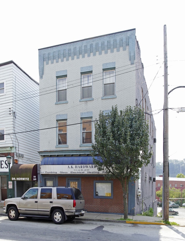
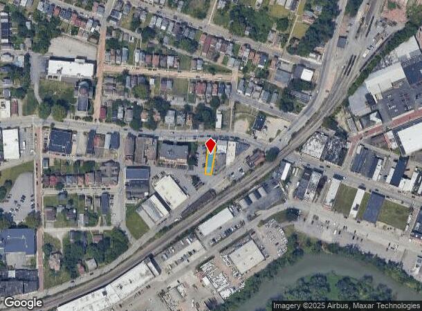
Property Record
717 Chartiers Ave, Mc Kees Rocks, PA 15136

NEARBY LISTINGS FOR SALE OR LEASE
Property Detail
717 Chartiers Ave
Pittsburgh, PA
LOT 32XAVG153.62X28 RR CHARTIERS AVE 3 STY BRK HSE & STO 717 1-2 CAR C B GAR
0043-J-00125-0000-00
Allegheny
Retailwithmorethanonenonretailuse
Pennsylvania
X
125
42003C0333H
0.11 AC
2024
West Pittsburgh
2025
Pittsburgh
464400
DEMOGRAPHICS near 717 Chartiers Ave
1 Mile
3 Mile
5 Mile
2024 Total Population
15,946
94,315
229,682
2029 Population
15,902
92,865
226,099
Pop Growth 2024-2029
(0.28%)
(1.54%)
(1.56%)
Average Age
39
41
41
2024 Total Households
6,852
43,595
106,916
HH Growth 2024-2029
(0.45%)
(1.66%)
(1.54%)
Median Household Inc
$39,935
$56,766
$64,733
Avg Household Size
2.20
2.10
2.00
2024 Avg HH Vehicles
1.00
1.00
1.00
Median Home Value
$72,714
$149,777
$175,843
Median Year Built
1948
1949
1953
Nearby Places
Map Layers
Map Styles
 Street
 Aerial
- Restaurants
- Banks
- Shops
- Fitness
- Groceries
PUBLIC TRANSPORTATION
COMMUTER RAIL
DRIVE
WALK
Distance
10 min
4.9 mi
AIRPORT
Pittsburgh International
DRIVE
WALK
Distance
Pittsburgh International
26 min
12.9 mi
Arnold Palmer Regional
DRIVE
WALK
Distance
Arnold Palmer Regional
73 min
47.1 mi
Nearby Properties
Address
Land Use
TOTAL SIZE
Lot Size
Zoning
Address
Land Use
TOTAL SIZE
Lot Size
Zoning
10.41 AC
Address
Land Use
TOTAL SIZE
Lot Size
Zoning
13.75 AC
Address
Land Use
TOTAL SIZE
Lot Size
Zoning
26.68 AC
Address
Land Use
TOTAL SIZE
Lot Size
Zoning
Address
Land Use
TOTAL SIZE
Lot Size
Zoning
21.20 AC
Address
Land Use
TOTAL SIZE
Lot Size
Zoning
105.09 AC
Address
Land Use
TOTAL SIZE
Lot Size
Zoning
6.55 AC
Address
Land Use
TOTAL SIZE
Lot Size
Zoning
1.66 AC
Address
Land Use
TOTAL SIZE
Lot Size
Zoning
6.40 AC
Address
Land Use
TOTAL SIZE
Lot Size
Zoning
1.22 AC
Address
Land Use
TOTAL SIZE
Lot Size
Zoning
16.54 AC
Address
Land Use
TOTAL SIZE
Lot Size
Zoning
1,556 SF
36.30 AC
Address
Land Use
TOTAL SIZE
Lot Size
Zoning
25.70 AC
Address
Land Use
TOTAL SIZE
Lot Size
Zoning
Address
Land Use
TOTAL SIZE
Lot Size
Zoning
Address
Land Use
TOTAL SIZE
Lot Size
Zoning
72.69 AC
Address
Land Use
TOTAL SIZE
Lot Size
Zoning
25.09 AC
Address
Land Use
TOTAL SIZE
Lot Size
Zoning
24.04 AC
Address
Land Use
TOTAL SIZE
Lot Size
Zoning
39.74 AC
Address
Land Use
TOTAL SIZE
Lot Size
Zoning
Address
Land Use
TOTAL SIZE
Lot Size
Zoning
3.83 AC
Address
Land Use
TOTAL SIZE
Lot Size
Zoning
13.86 AC
Address
Land Use
TOTAL SIZE
Lot Size
Zoning
Address
Land Use
TOTAL SIZE
Lot Size
Zoning
Address
Land Use
TOTAL SIZE
Lot Size
Zoning
11.93 AC
Address
Land Use
TOTAL SIZE
Lot Size
Zoning
2.51 AC
Address
Land Use
TOTAL SIZE
Lot Size
Zoning
9.18 AC
Address
Land Use
TOTAL SIZE
Lot Size
Zoning
21.49 AC
Address
Land Use
TOTAL SIZE
Lot Size
Zoning
Address
Land Use
TOTAL SIZE
Lot Size
Zoning
The World's #1 Commercial Real Estate Marketplace
Connect with us
© 2026 CoStar Group
The information above has been obtained from sources believed reliable. While we do not doubt its accuracy we have not verified it and make no guarantee, warranty or representation about it. It is your responsibility to independently confirm its accuracy and completeness. Any projections, opinions, assumptions, or estimates used are for example only and do not represent the current or future performance of the property. The value of this transaction to you depends on tax and other factors which should be evaluated by your tax, financial, and legal advisors. You and your advisors should conduct a careful, independent investigation of the property to determine to your satisfaction the suitability of the property for your needs.