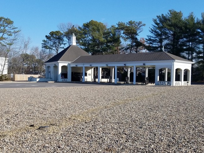
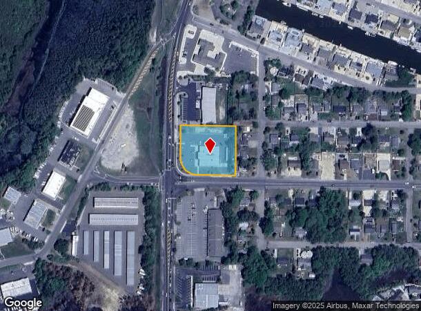
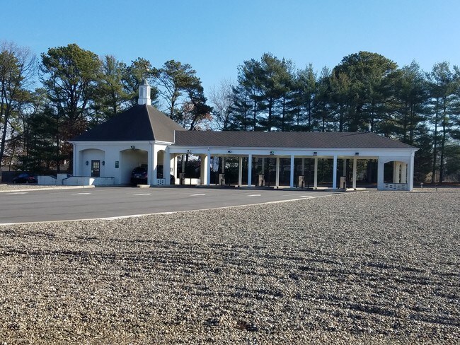
Property Record
717 S Main St, Forked River, NJ 08731
NEARBY LISTINGS FOR SALE OR LEASE
Property Detail
717 S Main St
Lakewood-New Brunswick, NJ
1.16 ACRES
13-00113-0000-00014
Ocean
Commercialnec
New Jersey
X
14
34029C0404F
1.16 AC
2024
Ocean County
2025
Northern New Jersey
732104
DEMOGRAPHICS near 717 S Main St
1 Mile
3 Mile
5 Mile
2024 Total Population
2,783
27,319
52,877
2029 Population
2,971
29,262
56,579
Pop Growth 2024-2029
+ 6.76%
+ 7.11%
+ 7.00%
Average Age
41
42
43
2024 Total Households
1,123
10,602
20,381
HH Growth 2024-2029
+ 6.50%
+ 6.74%
+ 6.61%
Median Household Inc
$60,437
$87,860
$91,797
Avg Household Size
2.40
2.50
2.50
2024 Avg HH Vehicles
2.00
2.00
2.00
Median Home Value
$298,115
$335,479
$340,373
Median Year Built
1981
1980
1983
Nearby Places
Map Layers
Map Styles
 Street
 Aerial
- Restaurants
- Banks
- Shops
- Fitness
- Groceries
SALE & LEASE HISTORY
LISTING DATE
SALE/LEASE

Feb 10, 2017
For Sale
Nearby Properties
Address
Land Use
TOTAL SIZE
Lot Size
Zoning
Address
Land Use
TOTAL SIZE
Lot Size
Zoning
139.60 AC
M6
Address
Land Use
TOTAL SIZE
Lot Size
Zoning
96.60 AC
R100
Address
Land Use
TOTAL SIZE
Lot Size
Zoning
528.70 AC
M6
Address
Land Use
TOTAL SIZE
Lot Size
Zoning
15.27 AC
C-2
Address
Land Use
TOTAL SIZE
Lot Size
Zoning
1,807.87 AC
FA
Address
Land Use
TOTAL SIZE
Lot Size
Zoning
21.34 AC
C200
Address
Land Use
TOTAL SIZE
Lot Size
Zoning
10.49 AC
PURD
Address
Land Use
TOTAL SIZE
Lot Size
Zoning
9,617 SF
14.28 AC
WTB1
Address
Land Use
TOTAL SIZE
Lot Size
Zoning
142,047 SF
18.72 AC
C150
Address
Land Use
TOTAL SIZE
Lot Size
Zoning
9.88 AC
C150
Address
Land Use
TOTAL SIZE
Lot Size
Zoning
2.76 AC
TC
Address
Land Use
TOTAL SIZE
Lot Size
Zoning
15.12 AC
R-2
Address
Land Use
TOTAL SIZE
Lot Size
Zoning
9.32 AC
TCO+
Address
Land Use
TOTAL SIZE
Lot Size
Zoning
6,600 SF
10.67 AC
PRD
Address
Land Use
TOTAL SIZE
Lot Size
Zoning
960 SF
9.62 AC
R100
Address
Land Use
TOTAL SIZE
Lot Size
Zoning
19.28 AC
MLOF
Address
Land Use
TOTAL SIZE
Lot Size
Zoning
6.14 AC
C150
Address
Land Use
TOTAL SIZE
Lot Size
Zoning
11.24 AC
R-2
Address
Land Use
TOTAL SIZE
Lot Size
Zoning
9.45 AC
C200
Address
Land Use
TOTAL SIZE
Lot Size
Zoning
9.65 AC
R-75
Address
Land Use
TOTAL SIZE
Lot Size
Zoning
37.70 AC
TCMX
Address
Land Use
TOTAL SIZE
Lot Size
Zoning
8.44 AC
AH10
Address
Land Use
TOTAL SIZE
Lot Size
Zoning
89.90 AC
R-2
Address
Land Use
TOTAL SIZE
Lot Size
Zoning
2,557 SF
633.96 AC
Address
Land Use
TOTAL SIZE
Lot Size
Zoning
8.76 AC
C150
Address
Land Use
TOTAL SIZE
Lot Size
Zoning
18.15 AC
TCMX
Address
Land Use
TOTAL SIZE
Lot Size
Zoning
40 AC
TCEC
Address
Land Use
TOTAL SIZE
Lot Size
Zoning
5.86 AC
AH10
Address
Land Use
TOTAL SIZE
Lot Size
Zoning
18,980 SF
4.19 AC
TCEC
Address
Land Use
TOTAL SIZE
Lot Size
Zoning
5 AC
C200
The World's #1 Commercial Real Estate Marketplace
Connect with us
© 2026 CoStar Group
The information above has been obtained from sources believed reliable. While we do not doubt its accuracy we have not verified it and make no guarantee, warranty or representation about it. It is your responsibility to independently confirm its accuracy and completeness. Any projections, opinions, assumptions, or estimates used are for example only and do not represent the current or future performance of the property. The value of this transaction to you depends on tax and other factors which should be evaluated by your tax, financial, and legal advisors. You and your advisors should conduct a careful, independent investigation of the property to determine to your satisfaction the suitability of the property for your needs.