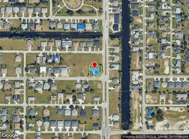
Property Record
717 Se 8Th St, Cape Coral, FL 33990
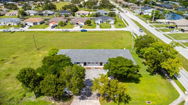
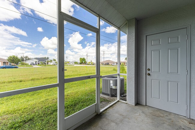
This Property Is For Sale
NEARBY LISTINGS FOR SALE OR LEASE
Property Detail
717 Se 8Th St
Cape Coral-Fort Myers, FL
Cape Coral
13-44-23-C3-01073.0180
CAPE CORAL UNIT 23 BLK 1073 PB 14 PG 42 LOTS 18 19 + 20
Multifamilydwelling
Lee
X
Florida
12071C0264G
18
2024
0.40 AC
2025
Hancock
010306
Southwest Florida
4,838 SF
DEMOGRAPHICS near 717 Se 8Th St
1 Mile
3 Mile
5 Mile
2024 Total Population
11,323
76,015
171,542
2029 Population
12,172
82,245
186,841
Pop Growth 2024-2029
+ 7.50%
+ 8.20%
+ 8.92%
Average Age
42
42
43
2024 Total Households
4,315
28,475
66,122
HH Growth 2024-2029
+ 6.84%
+ 7.45%
+ 8.25%
Median Household Inc
$57,948
$69,555
$71,987
Avg Household Size
2.50
2.60
2.50
2024 Avg HH Vehicles
2.00
2.00
2.00
Median Home Value
$366,636
$360,141
$375,221
Median Year Built
1995
1995
1997
Nearby Places
Map Layers
Map Styles
 Street
 Aerial
- Restaurants
- Banks
- Shops
- Fitness
- Groceries
PUBLIC TRANSPORTATION
AIRPORT
Southwest Florida International
DRIVE
WALK
Distance
Southwest Florida International
34 min
20.6 mi
Punta Gorda
DRIVE
WALK
Distance
Punta Gorda
37 min
24.9 mi
Freight Ports
Port Manatee
DRIVE
WALK
Distance
Port Manatee
117 min
96.6 mi
Nearby Properties
Address
Land Use
TOTAL SIZE
Lot Size
Zoning
Address
Land Use
TOTAL SIZE
Lot Size
Zoning
634,872 SF
43.30 AC
C1-D
Address
Land Use
TOTAL SIZE
Lot Size
Zoning
476,419 SF
36.49 AC
C1
Address
Land Use
TOTAL SIZE
Lot Size
Zoning
25.99 AC
RML
Address
Land Use
TOTAL SIZE
Lot Size
Zoning
231,454 SF
14.53 AC
CC
Address
Land Use
TOTAL SIZE
Lot Size
Zoning
339,525 SF
38.30 AC
R1BD
Address
Land Use
TOTAL SIZE
Lot Size
Zoning
7.82 AC
CORR
Address
Land Use
TOTAL SIZE
Lot Size
Zoning
282,066 SF
39.45 AC
INS
Address
Land Use
TOTAL SIZE
Lot Size
Zoning
61,844 SF
7.31 AC
CC
Address
Land Use
TOTAL SIZE
Lot Size
Zoning
278,679 SF
29.21 AC
C1-D
Address
Land Use
TOTAL SIZE
Lot Size
Zoning
101,204 SF
12.34 AC
P1-D
Address
Land Use
TOTAL SIZE
Lot Size
Zoning
139,978 SF
10.75 AC
C-1
Address
Land Use
TOTAL SIZE
Lot Size
Zoning
27.77 AC
RML
Address
Land Use
TOTAL SIZE
Lot Size
Zoning
142,773 SF
10.82 AC
C-1
Address
Land Use
TOTAL SIZE
Lot Size
Zoning
54,248 SF
15.42 AC
C1-W
Address
Land Use
TOTAL SIZE
Lot Size
Zoning
101,999 SF
7.17 AC
P-1
Address
Land Use
TOTAL SIZE
Lot Size
Zoning
99,749 SF
11.49 AC
WSHP
Address
Land Use
TOTAL SIZE
Lot Size
Zoning
124,182 SF
13.30 AC
CORR
Address
Land Use
TOTAL SIZE
Lot Size
Zoning
83,035 SF
19.01 AC
CORR
Address
Land Use
TOTAL SIZE
Lot Size
Zoning
153,651 SF
17.17 AC
R1-B
Address
Land Use
TOTAL SIZE
Lot Size
Zoning
124,101 SF
11.60 AC
C-1
Address
Land Use
TOTAL SIZE
Lot Size
Zoning
142,379 SF
3.27 AC
Address
Land Use
TOTAL SIZE
Lot Size
Zoning
62,119 SF
6.50 AC
CORR
Address
Land Use
TOTAL SIZE
Lot Size
Zoning
76,042 SF
7.50 AC
CORR
Address
Land Use
TOTAL SIZE
Lot Size
Zoning
101,110 SF
8.67 AC
VILL
Address
Land Use
TOTAL SIZE
Lot Size
Zoning
78,298 SF
12.73 AC
CORR
Address
Land Use
TOTAL SIZE
Lot Size
Zoning
102,818 SF
8.60 AC
CORR
Address
Land Use
TOTAL SIZE
Lot Size
Zoning
227,560 SF
27.45 AC
C1-D
Address
Land Use
TOTAL SIZE
Lot Size
Zoning
47,660 SF
3.52 AC
C1-D
Address
Land Use
TOTAL SIZE
Lot Size
Zoning
10,377 SF
3.34 AC
RML
Address
Land Use
TOTAL SIZE
Lot Size
Zoning
95,942 SF
5.22 AC
C1-D
The World's #1 Commercial Real Estate Marketplace
Connect with us
© 2026 CoStar Group
The information above has been obtained from sources believed reliable. While we do not doubt its accuracy we have not verified it and make no guarantee, warranty or representation about it. It is your responsibility to independently confirm its accuracy and completeness. Any projections, opinions, assumptions, or estimates used are for example only and do not represent the current or future performance of the property. The value of this transaction to you depends on tax and other factors which should be evaluated by your tax, financial, and legal advisors. You and your advisors should conduct a careful, independent investigation of the property to determine to your satisfaction the suitability of the property for your needs.