Property Record
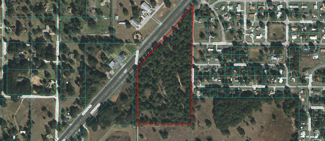
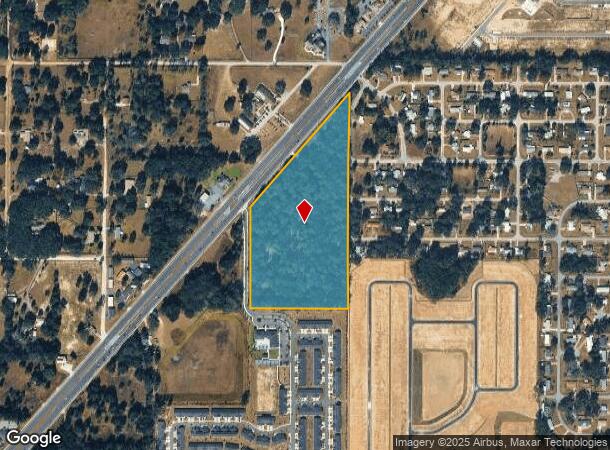
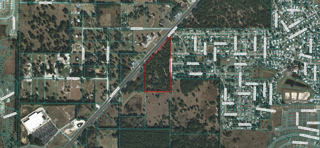
7172 Sw Highway 200, Ocala, FL 34476
This Property Is For Sale
NEARBY LISTINGS FOR SALE OR LEASE
Property Detail
7172 Sw Highway 200
3565-000-000
Whispering Pines Estates-Vacated Or 217/
Commercialacreage
SEC 18 TWP 16 RGE 21 THOSE PARTS OF N 3/4TH OF E 1/2 OF NE 1/4 OF SE 1/4 & SE 1/4 OF NE 1/4 LYING S & E OF SR 200 S 12 FT RESERVED FOR PUBLIC LANE AS RECORDED IN OR 1467- 0596 & EXC SR 200 ROW LYING WITHIN THE FOLLOWING DESC BDYS: LYING WITHIN 76.00
X
Marion
12083C0701E
Florida
2024
16.75 AC
2024
Outlying Marion County
001009
Ocala
2,488 SF
Ocala, FL
DEMOGRAPHICS near 7172 Sw Highway 200
1 Mile
3 Mile
5 Mile
2024 Total Population
3,201
35,576
61,335
2029 Population
3,624
40,331
69,584
Pop Growth 2024-2029
+ 13.21%
+ 13.37%
+ 13.45%
Average Age
54
59
54
2024 Total Households
1,500
17,743
28,684
HH Growth 2024-2029
+ 13.20%
+ 13.28%
+ 13.32%
Median Household Inc
$51,534
$56,755
$59,653
Avg Household Size
2.10
2.00
2.10
2024 Avg HH Vehicles
2.00
1.00
2.00
Median Home Value
$185,800
$200,893
$209,029
Median Year Built
1995
1997
1999
Nearby Places
Map Layers
Map Styles
 Street
 Aerial
- Restaurants
- Banks
- Shops
- Fitness
- Groceries
Nearby Properties
Address
Land Use
TOTAL SIZE
Lot Size
Zoning
Address
Land Use
TOTAL SIZE
Lot Size
Zoning
189,662 SF
25.54 AC
B2
Address
Land Use
TOTAL SIZE
Lot Size
Zoning
155,077 SF
40.05 AC
PUD
Address
Land Use
TOTAL SIZE
Lot Size
Zoning
124,557 SF
39.04 AC
GU
Address
Land Use
TOTAL SIZE
Lot Size
Zoning
96,094 SF
13.66 AC
B2
Address
Land Use
TOTAL SIZE
Lot Size
Zoning
62,253 SF
6.52 AC
PUD
Address
Land Use
TOTAL SIZE
Lot Size
Zoning
95,496 SF
25.25 AC
R3
Address
Land Use
TOTAL SIZE
Lot Size
Zoning
74,928 SF
7.80 AC
PUD
Address
Land Use
TOTAL SIZE
Lot Size
Zoning
18,035 SF
3.33 AC
B2
Address
Land Use
TOTAL SIZE
Lot Size
Zoning
55,985 SF
21.78 AC
B4
Address
Land Use
TOTAL SIZE
Lot Size
Zoning
139,728 SF
22.86 AC
B4
Address
Land Use
TOTAL SIZE
Lot Size
Zoning
84,004 SF
9.77 AC
SC
Address
Land Use
TOTAL SIZE
Lot Size
Zoning
65,060 SF
11.90 AC
B2
Address
Land Use
TOTAL SIZE
Lot Size
Zoning
98,205 SF
13.41 AC
B2
Address
Land Use
TOTAL SIZE
Lot Size
Zoning
42,673 SF
13.72 AC
A1
Address
Land Use
TOTAL SIZE
Lot Size
Zoning
42,159 SF
5.95 AC
B2
Address
Land Use
TOTAL SIZE
Lot Size
Zoning
48,518 SF
84.49 AC
A1
Address
Land Use
TOTAL SIZE
Lot Size
Zoning
47,600 SF
735.53 AC
PD
Address
Land Use
TOTAL SIZE
Lot Size
Zoning
99,045 SF
7.19 AC
B2
Address
Land Use
TOTAL SIZE
Lot Size
Zoning
82,465 SF
6.13 AC
B2
Address
Land Use
TOTAL SIZE
Lot Size
Zoning
286.80 AC
PUD
Address
Land Use
TOTAL SIZE
Lot Size
Zoning
58,381 SF
5.12 AC
R3
Address
Land Use
TOTAL SIZE
Lot Size
Zoning
13,943 SF
0.43 AC
B2
Address
Land Use
TOTAL SIZE
Lot Size
Zoning
25,128 SF
4.38 AC
PD
Address
Land Use
TOTAL SIZE
Lot Size
Zoning
16,214 SF
4.91 AC
B2
Address
Land Use
TOTAL SIZE
Lot Size
Zoning
27,862 SF
17.04 AC
A1
Address
Land Use
TOTAL SIZE
Lot Size
Zoning
38,062 SF
3.07 AC
B2
Address
Land Use
TOTAL SIZE
Lot Size
Zoning
35,280 SF
4.02 AC
B2
Address
Land Use
TOTAL SIZE
Lot Size
Zoning
45,364 SF
6.69 AC
B2
Address
Land Use
TOTAL SIZE
Lot Size
Zoning
16,308 SF
1.74 AC
B2
The World's #1 Commercial Real Estate Marketplace
Connect with us
© 2025 CoStar Group
The information above has been obtained from sources believed reliable. While we do not doubt its accuracy we have not verified it and make no guarantee, warranty or representation about it. It is your responsibility to independently confirm its accuracy and completeness. Any projections, opinions, assumptions, or estimates used are for example only and do not represent the current or future performance of the property. The value of this transaction to you depends on tax and other factors which should be evaluated by your tax, financial, and legal advisors. You and your advisors should conduct a careful, independent investigation of the property to determine to your satisfaction the suitability of the property for your needs.