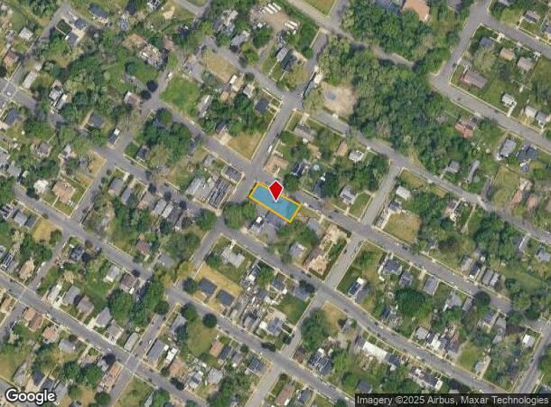
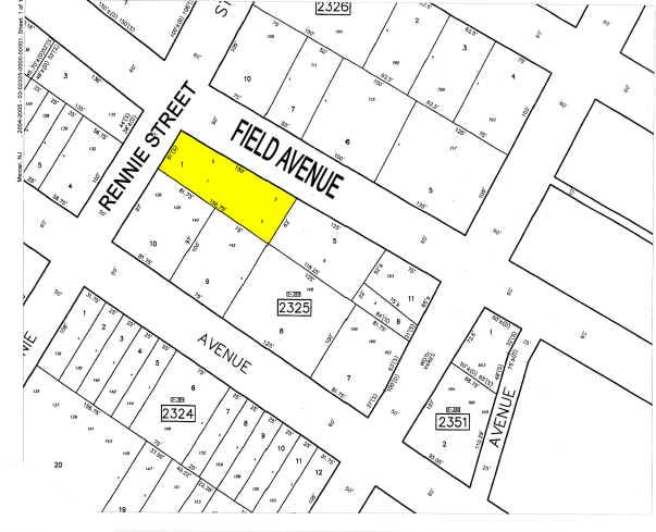
Property Record
718 Rennie St, Trenton, NJ 08610
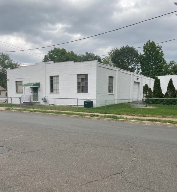
This Property Is For Sale
NEARBY LISTINGS FOR SALE OR LEASE
Property Detail
718 Rennie St
Trenton, NJ
Incl
03-02325-0000-00001
05409-
Vacantlandnec
Mercer
X
New Jersey
34021C0228F
1
2024
0.22 AC
2025
Trenton/295
002601
Northern New Jersey
9,636 SF
DEMOGRAPHICS near 718 Rennie St
1 Mile
3 Mile
5 Mile
2024 Total Population
22,300
129,813
240,040
2029 Population
21,973
127,699
237,449
Pop Growth 2024-2029
(1.47%)
(1.63%)
(1.08%)
Average Age
37
38
40
2024 Total Households
7,609
46,379
88,638
HH Growth 2024-2029
(1.58%)
(1.66%)
(1.13%)
Median Household Inc
$70,492
$61,990
$71,125
Avg Household Size
2.80
2.70
2.60
2024 Avg HH Vehicles
2.00
2.00
2.00
Median Home Value
$177,016
$199,317
$244,514
Median Year Built
1950
1952
1956
Nearby Places
Map Layers
Map Styles
 Street
 Aerial
- Restaurants
- Banks
- Shops
- Fitness
- Groceries
PUBLIC TRANSPORTATION
COMMUTER RAIL
DRIVE
WALK
Distance
7 min
2.6 mi
Trenton Transit Center (NJT) (Northeast Corridor Line - NJ Transit Commuter Rail (NJ Transit), River LINE - River LINE (River LINE))
DRIVE
WALK
Distance
Trenton Transit Center (NJT) (Northeast Corridor Line - NJ Transit Commuter Rail (NJ Transit), River LINE - River LINE (River LINE))
9 min
2.7 mi
AIRPORT
Trenton Mercer
DRIVE
WALK
Distance
Trenton Mercer
18 min
8.9 mi
Philadelphia International
DRIVE
WALK
Distance
Philadelphia International
64 min
47.2 mi
Freight Ports
Port of Philadelphia
DRIVE
WALK
Distance
Port of Philadelphia
48 min
31.2 mi
Nearby Properties
Address
Land Use
TOTAL SIZE
Lot Size
Zoning
Address
Land Use
TOTAL SIZE
Lot Size
Zoning
8.23 AC
BA
Address
Land Use
TOTAL SIZE
Lot Size
Zoning
26 AC
HIST
Address
Land Use
TOTAL SIZE
Lot Size
Zoning
6.69 AC
BA
Address
Land Use
TOTAL SIZE
Lot Size
Zoning
13.73 AC
Address
Land Use
TOTAL SIZE
Lot Size
Zoning
Address
Land Use
TOTAL SIZE
Lot Size
Zoning
879,376 SF
2.54 AC
BA
Address
Land Use
TOTAL SIZE
Lot Size
Zoning
43,715 SF
49.95 AC
Address
Land Use
TOTAL SIZE
Lot Size
Zoning
104,448 SF
8.49 AC
IA
Address
Land Use
TOTAL SIZE
Lot Size
Zoning
5.38 AC
MU
Address
Land Use
TOTAL SIZE
Lot Size
Zoning
288,000 SF
1.23 AC
BA
Address
Land Use
TOTAL SIZE
Lot Size
Zoning
35.83 AC
RB
Address
Land Use
TOTAL SIZE
Lot Size
Zoning
0.24 AC
BA
Address
Land Use
TOTAL SIZE
Lot Size
Zoning
186,960 SF
2.37 AC
BA
Address
Land Use
TOTAL SIZE
Lot Size
Zoning
212,074 SF
0.82 AC
BA
Address
Land Use
TOTAL SIZE
Lot Size
Zoning
13.85 AC
MU
Address
Land Use
TOTAL SIZE
Lot Size
Zoning
323,087 SF
1.95 AC
PM
Address
Land Use
TOTAL SIZE
Lot Size
Zoning
161,080 SF
2.21 AC
BA
Address
Land Use
TOTAL SIZE
Lot Size
Zoning
18.33 AC
Address
Land Use
TOTAL SIZE
Lot Size
Zoning
10.29 AC
RB
Address
Land Use
TOTAL SIZE
Lot Size
Zoning
158,000 SF
2.06 AC
BA
Address
Land Use
TOTAL SIZE
Lot Size
Zoning
4.07 AC
MU
Address
Land Use
TOTAL SIZE
Lot Size
Zoning
357 SF
0.96 AC
HIST
Address
Land Use
TOTAL SIZE
Lot Size
Zoning
260,160 SF
0.84 AC
BA
Address
Land Use
TOTAL SIZE
Lot Size
Zoning
161,520 SF
0.77 AC
BA
Address
Land Use
TOTAL SIZE
Lot Size
Zoning
23.53 AC
AT
Address
Land Use
TOTAL SIZE
Lot Size
Zoning
112,840 SF
Address
Land Use
TOTAL SIZE
Lot Size
Zoning
2.60 AC
BA
Address
Land Use
TOTAL SIZE
Lot Size
Zoning
27.50 AC
R7
Address
Land Use
TOTAL SIZE
Lot Size
Zoning
108,275 SF
0.90 AC
BA
Address
Land Use
TOTAL SIZE
Lot Size
Zoning
82,244 SF
5.35 AC
IA
The World's #1 Commercial Real Estate Marketplace
Connect with us
© 2025 CoStar Group
The information above has been obtained from sources believed reliable. While we do not doubt its accuracy we have not verified it and make no guarantee, warranty or representation about it. It is your responsibility to independently confirm its accuracy and completeness. Any projections, opinions, assumptions, or estimates used are for example only and do not represent the current or future performance of the property. The value of this transaction to you depends on tax and other factors which should be evaluated by your tax, financial, and legal advisors. You and your advisors should conduct a careful, independent investigation of the property to determine to your satisfaction the suitability of the property for your needs.