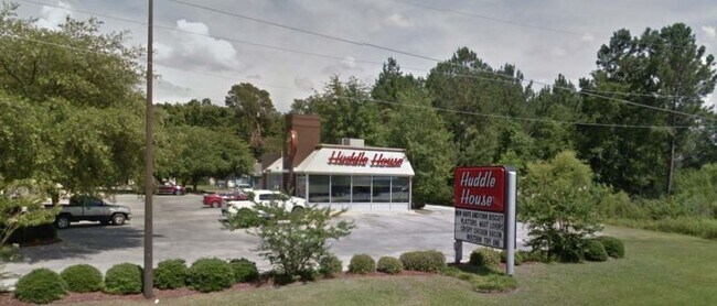
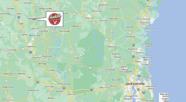
Property Record
718 S Davis St, Nashville, GA 31639

NEARBY LISTINGS FOR SALE OR LEASE
Property Detail
718 S Davis St
N12-13-000
Herman A Moore
Restaurantdrivein
718 S DAVIS ST
X
Berrien
13075C0150D
Georgia
2024
0.77 AC
2024
Georgia South Area
970500
Other Market Areas
2,542 SF
DEMOGRAPHICS near 718 S Davis St
1 Mile
3 Mile
5 Mile
2024 Total Population
2,389
6,023
7,807
2029 Population
2,381
6,011
7,800
Pop Growth 2024-2029
(0.33%)
(0.20%)
(0.09%)
Average Age
40
40
40
2024 Total Households
911
2,363
3,069
HH Growth 2024-2029
(0.11%)
(0.21%)
(0.10%)
Median Household Inc
$44,444
$42,822
$44,458
Avg Household Size
2.50
2.50
2.50
2024 Avg HH Vehicles
2.00
2.00
2.00
Median Home Value
$133,918
$112,680
$126,804
Median Year Built
1974
1975
1976
Nearby Places
Map Layers
Map Styles
 Street
 Aerial
- Restaurants
- Banks
- Shops
- Fitness
- Groceries
PUBLIC TRANSPORTATION
AIRPORT
Valdosta Regional
DRIVE
WALK
Distance
Valdosta Regional
50 min
31.1 mi
Freight Ports
Georgia Ports - Brunswick
DRIVE
WALK
Distance
Georgia Ports - Brunswick
151 min
116.0 mi
SALE & LEASE HISTORY
LISTING DATE
SALE/LEASE

Jun 25, 2020
For Lease
Jan 17, 2024
For Sale
Nearby Properties
Address
Land Use
TOTAL SIZE
Lot Size
Zoning
Address
Land Use
TOTAL SIZE
Lot Size
Zoning
30,462 SF
4.90 AC
RESIDENTIA
Address
Land Use
TOTAL SIZE
Lot Size
Zoning
14,255 SF
159.34 AC
INDUSTRIAL
Address
Land Use
TOTAL SIZE
Lot Size
Zoning
2,143 SF
5.67 AC
UNZONED SM
Address
Land Use
TOTAL SIZE
Lot Size
Zoning
11,912 SF
17.03 AC
RESIDENTIA
Address
Land Use
TOTAL SIZE
Lot Size
Zoning
2,750 SF
6.50 AC
RESIDENTIA
Address
Land Use
TOTAL SIZE
Lot Size
Zoning
12,912 SF
2.20 AC
RESIDENTIA
Address
Land Use
TOTAL SIZE
Lot Size
Zoning
41,464 SF
3.33 AC
RESIDENTIA
Address
Land Use
TOTAL SIZE
Lot Size
Zoning
112,300 SF
6.49 AC
RESIDENTIA
Address
Land Use
TOTAL SIZE
Lot Size
Zoning
19,760 SF
4 AC
Address
Land Use
TOTAL SIZE
Lot Size
Zoning
27,001 SF
2.70 AC
RESIDENTIA
Address
Land Use
TOTAL SIZE
Lot Size
Zoning
120,000 SF
4.75 AC
Address
Land Use
TOTAL SIZE
Lot Size
Zoning
120,000 SF
5.75 AC
Address
Land Use
TOTAL SIZE
Lot Size
Zoning
24,955 SF
2.12 AC
Address
Land Use
TOTAL SIZE
Lot Size
Zoning
1,430 SF
3.04 AC
RESIDENTIA
Address
Land Use
TOTAL SIZE
Lot Size
Zoning
10,913 SF
1.14 AC
RESIDENTIA
Address
Land Use
TOTAL SIZE
Lot Size
Zoning
10,004 SF
1.16 AC
RESIDENTIA
Address
Land Use
TOTAL SIZE
Lot Size
Zoning
26,706 SF
3.79 AC
RESIDENTIA
Address
Land Use
TOTAL SIZE
Lot Size
Zoning
13,116 SF
2.84 AC
RESIDENTIA
Address
Land Use
TOTAL SIZE
Lot Size
Zoning
29,058 SF
0.98 AC
RESIDENTIA
Address
Land Use
TOTAL SIZE
Lot Size
Zoning
13,000 SF
7.34 AC
COMMERCIAL
Address
Land Use
TOTAL SIZE
Lot Size
Zoning
5,000 SF
3.18 AC
UNZONED RU
Address
Land Use
TOTAL SIZE
Lot Size
Zoning
7,139 SF
8.23 AC
RESIDENTIA
Address
Land Use
TOTAL SIZE
Lot Size
Zoning
73,120 SF
3.90 AC
COMMERCIAL
Address
Land Use
TOTAL SIZE
Lot Size
Zoning
16,492 SF
2.63 AC
COMMERCIAL
Address
Land Use
TOTAL SIZE
Lot Size
Zoning
5,005 SF
0.92 AC
RESIDENTIA
The World's #1 Commercial Real Estate Marketplace
Connect with us
© 2025 CoStar Group
The information above has been obtained from sources believed reliable. While we do not doubt its accuracy we have not verified it and make no guarantee, warranty or representation about it. It is your responsibility to independently confirm its accuracy and completeness. Any projections, opinions, assumptions, or estimates used are for example only and do not represent the current or future performance of the property. The value of this transaction to you depends on tax and other factors which should be evaluated by your tax, financial, and legal advisors. You and your advisors should conduct a careful, independent investigation of the property to determine to your satisfaction the suitability of the property for your needs.