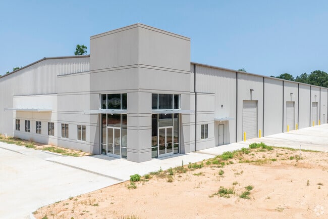
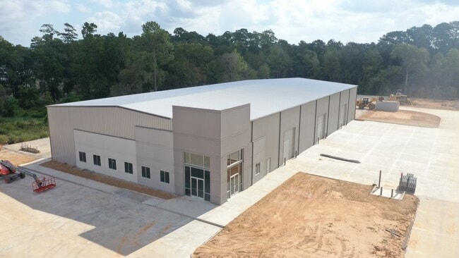
Property Record
7189 Old Highway 105 W, Conroe, TX 77304
NEARBY LISTINGS FOR SALE OR LEASE
Property Detail
7189 Old Highway 105 W
Houston-The Woodlands-Sugar Land, TX
Harbor Flats
5705-00-00200
S570500 - HARBOR FLATS, RES B, ACRES 6.59
Commercialacreage
Montgomery
2024
Texas
2025
6.59 AC
694401
The Woodlands/Conroe
45,000 SF
Houston
DEMOGRAPHICS near 7189 Old Highway 105 W
1 Mile
3 Mile
5 Mile
2024 Total Population
2,346
21,079
75,154
2029 Population
2,893
26,240
93,210
Pop Growth 2024-2029
+ 23.32%
+ 24.48%
+ 24.03%
Average Age
38
39
39
2024 Total Households
905
7,970
28,900
HH Growth 2024-2029
+ 23.43%
+ 24.55%
+ 24.09%
Median Household Inc
$66,652
$93,263
$83,476
Avg Household Size
2.60
2.60
2.60
2024 Avg HH Vehicles
2.00
2.00
2.00
Median Home Value
$230,065
$361,965
$333,100
Median Year Built
2010
2010
2009
Nearby Places
Map Layers
Map Styles
 Street
 Aerial
- Restaurants
- Banks
- Shops
- Fitness
- Groceries
PUBLIC TRANSPORTATION
AIRPORT
George Bush Intcntl/Houston
DRIVE
WALK
Distance
George Bush Intcntl/Houston
48 min
36.8 mi
Freight Ports
Port of Houston
DRIVE
WALK
Distance
Port of Houston
71 min
52.5 mi
SALE & LEASE HISTORY
LISTING DATE
SALE/LEASE

Jun 28, 2023
For Sale
Aug 10, 2022
For Sale
Aug 10, 2022
For Sale
Nearby Properties
Address
Land Use
TOTAL SIZE
Lot Size
Zoning
Address
Land Use
TOTAL SIZE
Lot Size
Zoning
296,593 SF
13.03 AC
Address
Land Use
TOTAL SIZE
Lot Size
Zoning
294,336 SF
20.39 AC
Address
Land Use
TOTAL SIZE
Lot Size
Zoning
204,716 SF
15.51 AC
Address
Land Use
TOTAL SIZE
Lot Size
Zoning
229,345 SF
12.36 AC
1
Address
Land Use
TOTAL SIZE
Lot Size
Zoning
134,935 SF
10.50 AC
1
Address
Land Use
TOTAL SIZE
Lot Size
Zoning
134,621 SF
26.37 AC
Address
Land Use
TOTAL SIZE
Lot Size
Zoning
313,974 SF
25.03 AC
1
Address
Land Use
TOTAL SIZE
Lot Size
Zoning
228,088 SF
16.16 AC
Address
Land Use
TOTAL SIZE
Lot Size
Zoning
157,996 SF
9 AC
Address
Land Use
TOTAL SIZE
Lot Size
Zoning
203,934 SF
11.75 AC
Address
Land Use
TOTAL SIZE
Lot Size
Zoning
382,810 SF
18.58 AC
1
Address
Land Use
TOTAL SIZE
Lot Size
Zoning
239,104 SF
65.54 AC
1
Address
Land Use
TOTAL SIZE
Lot Size
Zoning
114,547 SF
57.94 AC
1
Address
Land Use
TOTAL SIZE
Lot Size
Zoning
17,544 SF
24.25 AC
1
Address
Land Use
TOTAL SIZE
Lot Size
Zoning
114,101 SF
43.80 AC
Address
Land Use
TOTAL SIZE
Lot Size
Zoning
402,840 SF
26.73 AC
Address
Land Use
TOTAL SIZE
Lot Size
Zoning
81,011 SF
21.53 AC
Address
Land Use
TOTAL SIZE
Lot Size
Zoning
170,050 SF
10.80 AC
Address
Land Use
TOTAL SIZE
Lot Size
Zoning
45,301 SF
13.18 AC
1
Address
Land Use
TOTAL SIZE
Lot Size
Zoning
68,576 SF
26.39 AC
Address
Land Use
TOTAL SIZE
Lot Size
Zoning
74,395 SF
8.44 AC
Address
Land Use
TOTAL SIZE
Lot Size
Zoning
35,816 SF
251.16 AC
1
Address
Land Use
TOTAL SIZE
Lot Size
Zoning
104,735 SF
29.96 AC
1
Address
Land Use
TOTAL SIZE
Lot Size
Zoning
26,278 SF
9.39 AC
Address
Land Use
TOTAL SIZE
Lot Size
Zoning
14,957 SF
2.10 AC
1
Address
Land Use
TOTAL SIZE
Lot Size
Zoning
19,474 SF
12.76 AC
Address
Land Use
TOTAL SIZE
Lot Size
Zoning
54,511 SF
14.42 AC
1
Address
Land Use
TOTAL SIZE
Lot Size
Zoning
14,628 SF
1.33 AC
Address
Land Use
TOTAL SIZE
Lot Size
Zoning
29,500 SF
1.59 AC
The World's #1 Commercial Real Estate Marketplace
Connect with us
© 2026 CoStar Group
The information above has been obtained from sources believed reliable. While we do not doubt its accuracy we have not verified it and make no guarantee, warranty or representation about it. It is your responsibility to independently confirm its accuracy and completeness. Any projections, opinions, assumptions, or estimates used are for example only and do not represent the current or future performance of the property. The value of this transaction to you depends on tax and other factors which should be evaluated by your tax, financial, and legal advisors. You and your advisors should conduct a careful, independent investigation of the property to determine to your satisfaction the suitability of the property for your needs.