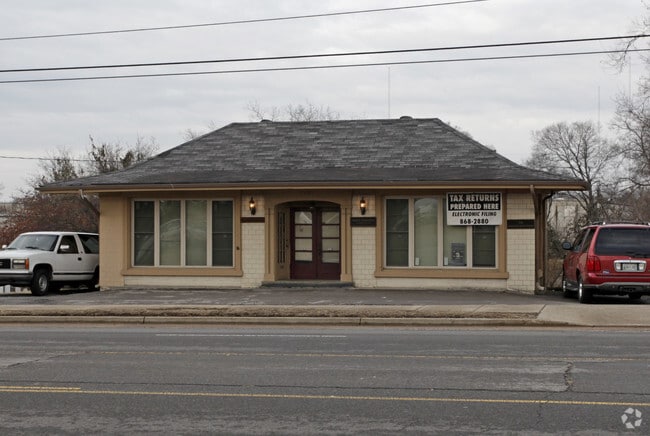
Property Record
719 Gallatin Pike N, Madison, TN 37115


Current Lease Availabilities
NEARBY LISTINGS FOR SALE OR LEASE
Property Detail
719 Gallatin Pike N
Nashville-Davidson--Murfreesboro--Franklin, TN
Map Of Madison Annex Subdivision
043-05-0-035
LOT 5 MADISON ANNEX
Officebuilding
Davidson
X
Tennessee
47037C0139H
5
2025
0.80 AC
2025
Rivergate/Hendersonville
010404
Nashville
1,600 SF
DEMOGRAPHICS near 719 Gallatin Pike N
1 Mile
3 Mile
5 Mile
2024 Total Population
11,629
50,909
109,325
2029 Population
11,571
50,735
109,807
Pop Growth 2024-2029
(0.50%)
(0.34%)
+ 0.44%
Average Age
39
40
40
2024 Total Households
4,911
21,579
45,699
HH Growth 2024-2029
(0.96%)
(0.67%)
+ 0.08%
Median Household Inc
$54,734
$55,569
$59,094
Avg Household Size
2.30
2.30
2.30
2024 Avg HH Vehicles
2.00
2.00
2.00
Median Home Value
$224,326
$266,509
$295,675
Median Year Built
1975
1979
1979
Nearby Places
Map Layers
Map Styles
 Street
 Aerial
- Restaurants
- Banks
- Shops
- Fitness
- Groceries
PUBLIC TRANSPORTATION
AIRPORT
Nashville International
DRIVE
WALK
Distance
Nashville International
24 min
15.5 mi
Nearby Properties
Address
Land Use
TOTAL SIZE
Lot Size
Zoning
Address
Land Use
TOTAL SIZE
Lot Size
Zoning
26,434 SF
12.86 AC
RM20
Address
Land Use
TOTAL SIZE
Lot Size
Zoning
27,585 SF
18.20 AC
SP
Address
Land Use
TOTAL SIZE
Lot Size
Zoning
34,160 SF
9.20 AC
R10
Address
Land Use
TOTAL SIZE
Lot Size
Zoning
102,738 SF
6.25 AC
MULTIZONE
Address
Land Use
TOTAL SIZE
Lot Size
Zoning
29,064 SF
15.11 AC
MULTIZONE
Address
Land Use
TOTAL SIZE
Lot Size
Zoning
11,088 SF
21.28 AC
RS7.5
Address
Land Use
TOTAL SIZE
Lot Size
Zoning
17,292 SF
12.35 AC
RM20
Address
Land Use
TOTAL SIZE
Lot Size
Zoning
30,534 SF
19.77 AC
SP
Address
Land Use
TOTAL SIZE
Lot Size
Zoning
102,431 SF
19.59 AC
6ZZ
Address
Land Use
TOTAL SIZE
Lot Size
Zoning
336,784 SF
41.54 AC
IR
Address
Land Use
TOTAL SIZE
Lot Size
Zoning
154,143 SF
8.88 AC
OG
Address
Land Use
TOTAL SIZE
Lot Size
Zoning
16,770 SF
76.79 AC
RM4
Address
Land Use
TOTAL SIZE
Lot Size
Zoning
17,214 SF
40.52 AC
RM9
Address
Land Use
TOTAL SIZE
Lot Size
Zoning
169,292 SF
12 AC
RM20
Address
Land Use
TOTAL SIZE
Lot Size
Zoning
6,120 SF
17.46 AC
R10
Address
Land Use
TOTAL SIZE
Lot Size
Zoning
162,261 SF
6.20 AC
RM40
Address
Land Use
TOTAL SIZE
Lot Size
Zoning
13,950 SF
17.60 AC
R8
Address
Land Use
TOTAL SIZE
Lot Size
Zoning
42,840 SF
21.43 AC
CS
Address
Land Use
TOTAL SIZE
Lot Size
Zoning
3,312 SF
33.03 AC
IR
Address
Land Use
TOTAL SIZE
Lot Size
Zoning
12,576 SF
16.09 AC
6ZZ
Address
Land Use
TOTAL SIZE
Lot Size
Zoning
146,323 SF
4.48 AC
RM40
Address
Land Use
TOTAL SIZE
Lot Size
Zoning
34,752 SF
19.09 AC
CS
Address
Land Use
TOTAL SIZE
Lot Size
Zoning
93,000 SF
16.44 AC
IR
Address
Land Use
TOTAL SIZE
Lot Size
Zoning
23,010 SF
23.52 AC
RS10
Address
Land Use
TOTAL SIZE
Lot Size
Zoning
112,056 SF
40.15 AC
MULTIZONE
Address
Land Use
TOTAL SIZE
Lot Size
Zoning
26,610 SF
6.66 AC
RS20
Address
Land Use
TOTAL SIZE
Lot Size
Zoning
3,864 SF
4.05 AC
RS5
Address
Land Use
TOTAL SIZE
Lot Size
Zoning
21,356 SF
11.25 AC
6ZZ
Address
Land Use
TOTAL SIZE
Lot Size
Zoning
17,500 SF
17.56 AC
SCR
Address
Land Use
TOTAL SIZE
Lot Size
Zoning
49,752 SF
5.36 AC
RS20
The World's #1 Commercial Real Estate Marketplace
Connect with us
© 2026 CoStar Group
The information above has been obtained from sources believed reliable. While we do not doubt its accuracy we have not verified it and make no guarantee, warranty or representation about it. It is your responsibility to independently confirm its accuracy and completeness. Any projections, opinions, assumptions, or estimates used are for example only and do not represent the current or future performance of the property. The value of this transaction to you depends on tax and other factors which should be evaluated by your tax, financial, and legal advisors. You and your advisors should conduct a careful, independent investigation of the property to determine to your satisfaction the suitability of the property for your needs.