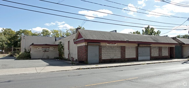
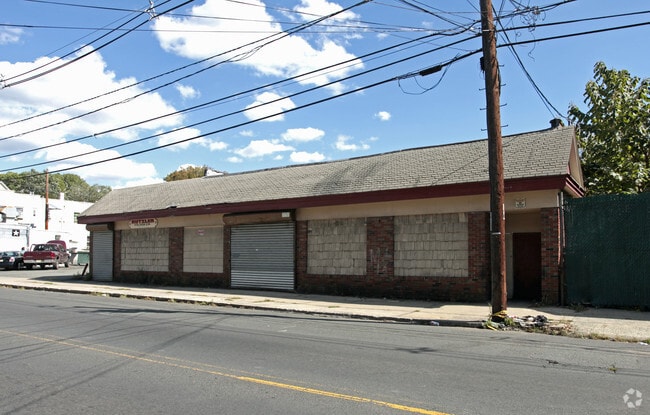
Property Record
719 W Front St, Plainfield, NJ 07060

Save to a Folder
{{folder.Name}}
{{folder.ListingIds.length}} Properties
{{folder.ListingIds.length}} Property
Create a New Folder
Property Detail
719 W Front St
12-00231-0000-00021
ADDITIONAL LOTS: 22217 SQ FT
Commercialnec
Union
MU
New Jersey
B and X Area of moderate flood hazard, usually the area between the limits of the 100-year and 500-year floods.
21
2025
0.74 AC
2026
Route 78/22 East
039400
Northern New Jersey
22,217 SF
Newark, NJ
NEARBY LISTINGS FOR SALE OR LEASE
DEMOGRAPHICS near 719 W Front St
1 mile
3 mile
5 mile
2025 Total Population
31,858
139,744
277,404
2030 Population
32,756
145,302
289,621
Pop Growth 2025-2030
+ 2.82%
+ 3.98%
+ 4.40%
Average Age
35
39
40
2025 Total Households
8,913
45,039
91,593
HH Growth 2025-2030
+ 2.92%
+ 4.15%
+ 4.57%
Median Household Inc
$79,596
$97,486
$124,219
Avg Household Size
3.40
3.00
2.90
2025 Avg HH Vehicles
2.00
2.00
2.00
Median Home Value
$396,736
$449,014
$553,730
Median Year Built
1948
1957
1964
Nearby Places
Map Layers
Map Styles
 Street
 Aerial
Layers
 Traffic
 Biking
Places
Listings with unknown addresses are not visible on the map
- Restaurants
- Banks
- Shops
- Fitness
- Groceries
PUBLIC TRANSPORTATION
COMMUTER RAIL
Plainfield (Raritan Valley Line - NJ Transit Commuter Rail (NJ Transit))
Drive
Walk
Distance
Plainfield (Raritan Valley Line - NJ Transit Commuter Rail (NJ Transit))
3 min
1.1 mi
Dunellen (Raritan Valley Line - NJ Transit Commuter Rail (NJ Transit))
Drive
Walk
Distance
Dunellen (Raritan Valley Line - NJ Transit Commuter Rail (NJ Transit))
4 min
2.1 mi
AIRPORT
Newark Liberty International
Drive
Walk
Distance
Newark Liberty International
32 min
22.0 mi
Trenton Mercer
Drive
Walk
Distance
Trenton Mercer
62 min
38.9 mi
LaGuardia
Drive
Walk
Distance
LaGuardia
68 min
41.2 mi
Freight Ports
New York Container Terminal
Drive
Walk
Distance
New York Container Terminal
36 min
18.4 mi
Nearby Properties
Address
Land Use
TOTAL SIZE
Lot Size
Zoning
Address
Land Use
TOTAL SIZE
Lot Size
Zoning
17.01 AC
RM
Address
Land Use
TOTAL SIZE
Lot Size
Zoning
20.08 AC
RML1
Address
Land Use
TOTAL SIZE
Lot Size
Zoning
17.64 AC
R10A
Address
Land Use
TOTAL SIZE
Lot Size
Zoning
11.04 AC
RM
Address
Land Use
TOTAL SIZE
Lot Size
Zoning
26.87 AC
H-D
Address
Land Use
TOTAL SIZE
Lot Size
Zoning
10.09 AC
Address
Land Use
TOTAL SIZE
Lot Size
Zoning
27.70 AC
Address
Land Use
TOTAL SIZE
Lot Size
Zoning
16.21 AC
RM
Address
Land Use
TOTAL SIZE
Lot Size
Zoning
233,217 SF
36.91 AC
LI5
Address
Land Use
TOTAL SIZE
Lot Size
Zoning
12.47 AC
H-D
Address
Land Use
TOTAL SIZE
Lot Size
Zoning
15.79 AC
H-D
Address
Land Use
TOTAL SIZE
Lot Size
Zoning
7.91 AC
RM
Address
Land Use
TOTAL SIZE
Lot Size
Zoning
9.38 AC
RM
Address
Land Use
TOTAL SIZE
Lot Size
Zoning
9.85 AC
10A
Address
Land Use
TOTAL SIZE
Lot Size
Zoning
19.84 AC
Address
Land Use
TOTAL SIZE
Lot Size
Zoning
30.80 AC
R10
Address
Land Use
TOTAL SIZE
Lot Size
Zoning
4.74 AC
NC
Address
Land Use
TOTAL SIZE
Lot Size
Zoning
16.97 AC
Address
Land Use
TOTAL SIZE
Lot Size
Zoning
30.40 AC
PR
Address
Land Use
TOTAL SIZE
Lot Size
Zoning
19.19 AC
R-3
Address
Land Use
TOTAL SIZE
Lot Size
Zoning
10,328 SF
7.53 AC
R4
Address
Land Use
TOTAL SIZE
Lot Size
Zoning
19.84 AC
H-D
Address
Land Use
TOTAL SIZE
Lot Size
Zoning
12.52 AC
H-D
Address
Land Use
TOTAL SIZE
Lot Size
Zoning
80,262 SF
11.47 AC
ER
Address
Land Use
TOTAL SIZE
Lot Size
Zoning
122,820 SF
14.65 AC
H-D
Address
Land Use
TOTAL SIZE
Lot Size
Zoning
23.45 AC
RHC
Address
Land Use
TOTAL SIZE
Lot Size
Zoning
11.20 AC
Address
Land Use
TOTAL SIZE
Lot Size
Zoning
10.93 AC
LI
Address
Land Use
TOTAL SIZE
Lot Size
Zoning
0.39 AC
R5
Address
Land Use
TOTAL SIZE
Lot Size
Zoning
11.02 AC
The World's #1 Commercial Real Estate Marketplace
Connect with us
© 2026 CoStar Group
The information above has been obtained from sources believed reliable. While we do not doubt its accuracy we have not verified it and make no guarantee, warranty or representation about it. It is your responsibility to independently confirm its accuracy and completeness. Any projections, opinions, assumptions, or estimates used are for example only and do not represent the current or future performance of the property. The value of this transaction to you depends on tax and other factors which should be evaluated by your tax, financial, and legal advisors. You and your advisors should conduct a careful, independent investigation of the property to determine to your satisfaction the suitability of the property for your needs.