Property Record
719 W Main St, Ionia, MI 48846

NEARBY LISTINGS FOR SALE OR LEASE
-
-
View all Ionia listings for sale on LoopNet.com
Property Detail
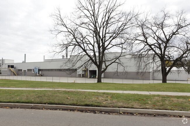
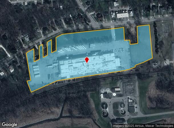
719 W Main St
Grand Rapids-Wyoming-Kentwood, MI
All Being Subject
202-100-000-130-11
CITY OF IONIA,MI THAT PART OF E 1/4 OF SEC 24, T7N, R7W, EASTONTWP,IONIA CO, MI AND THAT PART OF W 1/2 OF SEC 19, T7N, R6W,
Industrialgeneral
Ionia
AE
Michigan
26067C0177D
24
2024
11.92 AC
2025
Ionia County
032100
West Michigan
96,695 SF
DEMOGRAPHICS near 719 W Main St
1 Mile
3 Mile
5 Mile
2024 Total Population
6,408
18,822
21,474
2029 Population
6,568
19,150
21,858
Pop Growth 2024-2029
+ 2.50%
+ 1.74%
+ 1.79%
Average Age
39
40
40
2024 Total Households
2,148
4,883
5,861
HH Growth 2024-2029
+ 2.75%
+ 2.48%
+ 2.41%
Median Household Inc
$52,593
$56,581
$57,700
Avg Household Size
2.50
2.50
2.50
2024 Avg HH Vehicles
2.00
2.00
2.00
Median Home Value
$139,935
$144,056
$145,163
Median Year Built
1951
1961
1965
Nearby Places
Map Layers
Map Styles
 Street
 Aerial
- Restaurants
- Banks
- Shops
- Fitness
- Groceries
PUBLIC TRANSPORTATION
AIRPORT
Capital Region International
DRIVE
WALK
Distance
Capital Region International
46 min
35.6 mi
Gerald R Ford International
DRIVE
WALK
Distance
Gerald R Ford International
48 min
35.6 mi
Freight Ports
Port of Toledo
DRIVE
WALK
Distance
Port of Toledo
193 min
165.4 mi
Nearby Properties
Address
Land Use
TOTAL SIZE
Lot Size
Zoning
Address
Land Use
TOTAL SIZE
Lot Size
Zoning
680,827 SF
50 AC
I-1
Address
Land Use
TOTAL SIZE
Lot Size
Zoning
209,286 SF
23.37 AC
Address
Land Use
TOTAL SIZE
Lot Size
Zoning
178,310 SF
21.07 AC
Address
Land Use
TOTAL SIZE
Lot Size
Zoning
Address
Land Use
TOTAL SIZE
Lot Size
Zoning
1,286 SF
78 AC
R1
Address
Land Use
TOTAL SIZE
Lot Size
Zoning
111,316 SF
14.62 AC
Address
Land Use
TOTAL SIZE
Lot Size
Zoning
1,408 SF
136 AC
Address
Land Use
TOTAL SIZE
Lot Size
Zoning
131,333 SF
14.07 AC
Address
Land Use
TOTAL SIZE
Lot Size
Zoning
127,496 SF
10.70 AC
I-1
Address
Land Use
TOTAL SIZE
Lot Size
Zoning
94,800 SF
13.63 AC
Address
Land Use
TOTAL SIZE
Lot Size
Zoning
29,270 SF
3.09 AC
I-1
Address
Land Use
TOTAL SIZE
Lot Size
Zoning
31,585 SF
4.20 AC
RM-1
Address
Land Use
TOTAL SIZE
Lot Size
Zoning
1,920 SF
68.57 AC
Address
Land Use
TOTAL SIZE
Lot Size
Zoning
16.30 AC
RM-1
Address
Land Use
TOTAL SIZE
Lot Size
Zoning
31,242 SF
0.25 AC
B-2
Address
Land Use
TOTAL SIZE
Lot Size
Zoning
23,904 SF
0.31 AC
B-2
Address
Land Use
TOTAL SIZE
Lot Size
Zoning
4.31 AC
RM-1
Address
Land Use
TOTAL SIZE
Lot Size
Zoning
2,396 SF
72.30 AC
Address
Land Use
TOTAL SIZE
Lot Size
Zoning
24,672 SF
4.46 AC
Address
Land Use
TOTAL SIZE
Lot Size
Zoning
13,440 SF
5.50 AC
B-3
Address
Land Use
TOTAL SIZE
Lot Size
Zoning
5,247 SF
1.74 AC
Address
Land Use
TOTAL SIZE
Lot Size
Zoning
1,885 SF
1.17 AC
Address
Land Use
TOTAL SIZE
Lot Size
Zoning
7,200 SF
2.72 AC
Address
Land Use
TOTAL SIZE
Lot Size
Zoning
23,850 SF
4.30 AC
I-1
Address
Land Use
TOTAL SIZE
Lot Size
Zoning
1.45 AC
Address
Land Use
TOTAL SIZE
Lot Size
Zoning
6.48 AC
Address
Land Use
TOTAL SIZE
Lot Size
Zoning
32,565 SF
5.61 AC
Address
Land Use
TOTAL SIZE
Lot Size
Zoning
11,701 SF
2.13 AC
B-3
Address
Land Use
TOTAL SIZE
Lot Size
Zoning
14,224 SF
5.12 AC
The World's #1 Commercial Real Estate Marketplace
Connect with us
© 2026 CoStar Group
The information above has been obtained from sources believed reliable. While we do not doubt its accuracy we have not verified it and make no guarantee, warranty or representation about it. It is your responsibility to independently confirm its accuracy and completeness. Any projections, opinions, assumptions, or estimates used are for example only and do not represent the current or future performance of the property. The value of this transaction to you depends on tax and other factors which should be evaluated by your tax, financial, and legal advisors. You and your advisors should conduct a careful, independent investigation of the property to determine to your satisfaction the suitability of the property for your needs.