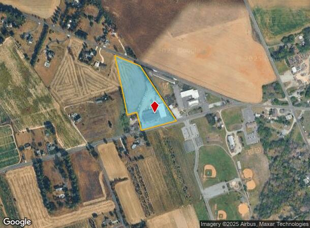
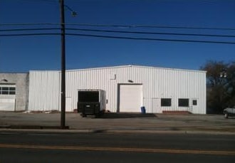
Property Record
719 Whig Ln, Monroeville, NJ 08343


NEARBY LISTINGS FOR SALE OR LEASE
Property Detail
719 Whig Ln
04-00033-0000-00012-01
Gloucester
Warehouse
New Jersey
X
12.1
34033C0120C
7.02 AC
2024
Gloucester County
2025
Philadelphia
501900
Philadelphia-Camden-Wilmington, PA-NJ-DE-MD
2,284 SF
DEMOGRAPHICS near 719 Whig Ln
1 Mile
3 Mile
5 Mile
2024 Total Population
318
21,720
62,430
2029 Population
328
22,741
64,633
Pop Growth 2024-2029
+ 3.14%
+ 4.70%
+ 3.53%
Average Age
41
38
39
2024 Total Households
109
7,575
21,058
HH Growth 2024-2029
+ 3.67%
+ 4.96%
+ 3.84%
Median Household Inc
$107,143
$77,728
$94,506
Avg Household Size
2.80
2.50
2.60
2024 Avg HH Vehicles
2.00
2.00
2.00
Median Home Value
$323,214
$263,372
$263,704
Median Year Built
1976
1983
1978
Nearby Places
Map Layers
Map Styles
 Street
 Aerial
- Restaurants
- Banks
- Shops
- Fitness
- Groceries
PUBLIC TRANSPORTATION
AIRPORT
Philadelphia International
DRIVE
WALK
Distance
Philadelphia International
36 min
29.2 mi
Atlantic City International
DRIVE
WALK
Distance
Atlantic City International
64 min
40.4 mi
Nearby Properties
Address
Land Use
TOTAL SIZE
Lot Size
Zoning
Address
Land Use
TOTAL SIZE
Lot Size
Zoning
2,302 SF
61.32 AC
C55
Address
Land Use
TOTAL SIZE
Lot Size
Zoning
96.68 AC
P
Address
Land Use
TOTAL SIZE
Lot Size
Zoning
3.34 AC
R3
Address
Land Use
TOTAL SIZE
Lot Size
Zoning
4.41 AC
Address
Land Use
TOTAL SIZE
Lot Size
Zoning
Address
Land Use
TOTAL SIZE
Lot Size
Zoning
Address
Land Use
TOTAL SIZE
Lot Size
Zoning
4.52 AC
P
Address
Land Use
TOTAL SIZE
Lot Size
Zoning
46.38 AC
P
Address
Land Use
TOTAL SIZE
Lot Size
Zoning
Address
Land Use
TOTAL SIZE
Lot Size
Zoning
25.71 AC
Address
Land Use
TOTAL SIZE
Lot Size
Zoning
Address
Land Use
TOTAL SIZE
Lot Size
Zoning
1.77 AC
Address
Land Use
TOTAL SIZE
Lot Size
Zoning
1.29 AC
Address
Land Use
TOTAL SIZE
Lot Size
Zoning
23.80 AC
R-B
Address
Land Use
TOTAL SIZE
Lot Size
Zoning
Address
Land Use
TOTAL SIZE
Lot Size
Zoning
2.68 AC
P
Address
Land Use
TOTAL SIZE
Lot Size
Zoning
1.52 AC
Address
Land Use
TOTAL SIZE
Lot Size
Zoning
7.57 AC
P
Address
Land Use
TOTAL SIZE
Lot Size
Zoning
Address
Land Use
TOTAL SIZE
Lot Size
Zoning
21.14 AC
CF/I
Address
Land Use
TOTAL SIZE
Lot Size
Zoning
0.91 AC
P
Address
Land Use
TOTAL SIZE
Lot Size
Zoning
Address
Land Use
TOTAL SIZE
Lot Size
Zoning
76.57 AC
I
Address
Land Use
TOTAL SIZE
Lot Size
Zoning
5.30 AC
P
Address
Land Use
TOTAL SIZE
Lot Size
Zoning
4.41 AC
Address
Land Use
TOTAL SIZE
Lot Size
Zoning
3.23 AC
P
Address
Land Use
TOTAL SIZE
Lot Size
Zoning
39.31 AC
I2
Address
Land Use
TOTAL SIZE
Lot Size
Zoning
3.17 AC
Address
Land Use
TOTAL SIZE
Lot Size
Zoning
17.78 AC
I2
Address
Land Use
TOTAL SIZE
Lot Size
Zoning
3,750 SF
5.55 AC
C3
The World's #1 Commercial Real Estate Marketplace
Connect with us
© 2025 CoStar Group
The information above has been obtained from sources believed reliable. While we do not doubt its accuracy we have not verified it and make no guarantee, warranty or representation about it. It is your responsibility to independently confirm its accuracy and completeness. Any projections, opinions, assumptions, or estimates used are for example only and do not represent the current or future performance of the property. The value of this transaction to you depends on tax and other factors which should be evaluated by your tax, financial, and legal advisors. You and your advisors should conduct a careful, independent investigation of the property to determine to your satisfaction the suitability of the property for your needs.