Property Record
7191 Cahaba Valley Rd, Hoover, AL 35242
NEARBY LISTINGS FOR SALE OR LEASE
Property Detail
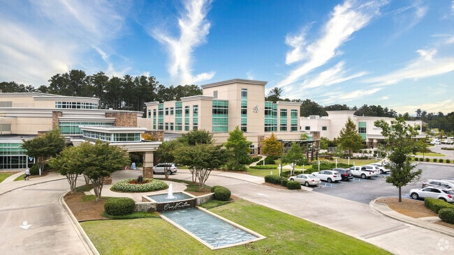
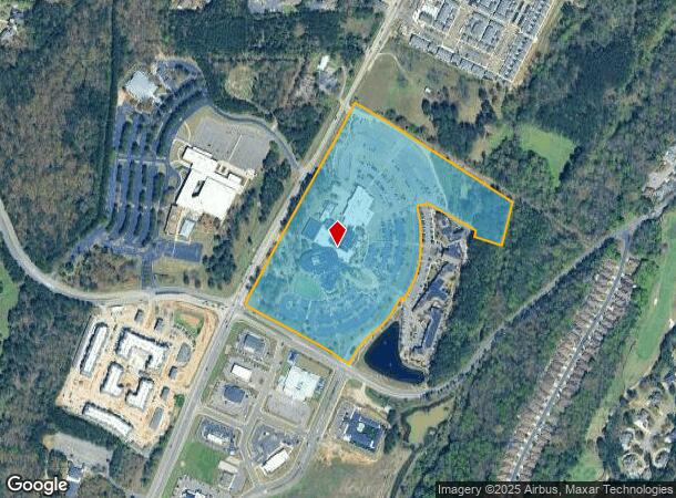
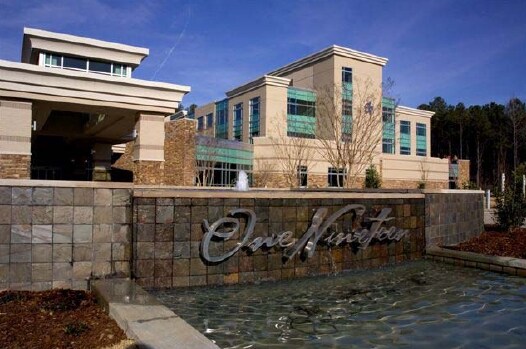
7191 Cahaba Valley Rd
Birmingham-Hoover, AL
St Vincents Hospital Hiway #119 Survey G
03-9-32-0-001-005-001
SEC/TWNSHP/RAN 32 18S 01W 2008 CERTIFICATE OF THE CITY CLERK OF HOOVER 20071017000481980 2008 RE-ANNEX 20071115000524130
Medicalbuilding
Shelby
AE
Alabama
01117C0091E
1a
2024
25.72 AC
2024
Hwy 280/Shelby County
030220
Birmingham
111,045 SF
DEMOGRAPHICS near 7191 Cahaba Valley Rd
1 Mile
3 Mile
5 Mile
2024 Total Population
6,547
36,749
73,621
2029 Population
7,039
39,637
77,124
Pop Growth 2024-2029
+ 7.51%
+ 7.86%
+ 4.76%
Average Age
43
42
41
2024 Total Households
2,750
15,583
30,985
HH Growth 2024-2029
+ 7.64%
+ 7.90%
+ 4.66%
Median Household Inc
$118,893
$101,173
$105,388
Avg Household Size
2.40
2.30
2.30
2024 Avg HH Vehicles
2.00
2.00
2.00
Median Home Value
$465,783
$427,574
$403,403
Median Year Built
1995
1995
1995
Nearby Places
Map Layers
Map Styles
 Street
 Aerial
- Restaurants
- Banks
- Shops
- Fitness
- Groceries
PUBLIC TRANSPORTATION
AIRPORT
Birmingham-Shuttlesworth International
DRIVE
WALK
Distance
Birmingham-Shuttlesworth International
27 min
16.4 mi
Nearby Properties
Address
Land Use
TOTAL SIZE
Lot Size
Zoning
Address
Land Use
TOTAL SIZE
Lot Size
Zoning
200,418 SF
6.50 AC
C1
Address
Land Use
TOTAL SIZE
Lot Size
Zoning
15,013 SF
79.12 AC
Address
Land Use
TOTAL SIZE
Lot Size
Zoning
4,674 SF
28.10 AC
Address
Land Use
TOTAL SIZE
Lot Size
Zoning
37,950 SF
26.50 AC
Address
Land Use
TOTAL SIZE
Lot Size
Zoning
30,967 SF
17.39 AC
Address
Land Use
TOTAL SIZE
Lot Size
Zoning
132,501 SF
50.39 AC
Address
Land Use
TOTAL SIZE
Lot Size
Zoning
4,335 SF
26.43 AC
Address
Land Use
TOTAL SIZE
Lot Size
Zoning
64,375 SF
8.99 AC
Address
Land Use
TOTAL SIZE
Lot Size
Zoning
11,058 SF
24.33 AC
Address
Land Use
TOTAL SIZE
Lot Size
Zoning
11,492 SF
21.30 AC
Address
Land Use
TOTAL SIZE
Lot Size
Zoning
2,404 SF
17.42 AC
Address
Land Use
TOTAL SIZE
Lot Size
Zoning
5,506 SF
17.36 AC
Address
Land Use
TOTAL SIZE
Lot Size
Zoning
144,210 SF
9.37 AC
Address
Land Use
TOTAL SIZE
Lot Size
Zoning
4,259 SF
24.94 AC
Address
Land Use
TOTAL SIZE
Lot Size
Zoning
1,400 SF
21.35 AC
Address
Land Use
TOTAL SIZE
Lot Size
Zoning
16,187 SF
33.04 AC
Address
Land Use
TOTAL SIZE
Lot Size
Zoning
60,656 SF
20.32 AC
Address
Land Use
TOTAL SIZE
Lot Size
Zoning
7,861 SF
29 AC
Address
Land Use
TOTAL SIZE
Lot Size
Zoning
251,087 SF
23 AC
R-4
Address
Land Use
TOTAL SIZE
Lot Size
Zoning
220,128 SF
24.49 AC
Address
Land Use
TOTAL SIZE
Lot Size
Zoning
11,020 SF
110 AC
A1
Address
Land Use
TOTAL SIZE
Lot Size
Zoning
16,243 SF
10.74 AC
Address
Land Use
TOTAL SIZE
Lot Size
Zoning
3,677 SF
19.52 AC
Address
Land Use
TOTAL SIZE
Lot Size
Zoning
2,220 SF
12.20 AC
Address
Land Use
TOTAL SIZE
Lot Size
Zoning
2,228 SF
18 AC
Address
Land Use
TOTAL SIZE
Lot Size
Zoning
68,655 SF
15.62 AC
Address
Land Use
TOTAL SIZE
Lot Size
Zoning
1,148 SF
23 AC
Address
Land Use
TOTAL SIZE
Lot Size
Zoning
10,852 SF
19 AC
The World's #1 Commercial Real Estate Marketplace
Connect with us
© 2026 CoStar Group
The information above has been obtained from sources believed reliable. While we do not doubt its accuracy we have not verified it and make no guarantee, warranty or representation about it. It is your responsibility to independently confirm its accuracy and completeness. Any projections, opinions, assumptions, or estimates used are for example only and do not represent the current or future performance of the property. The value of this transaction to you depends on tax and other factors which should be evaluated by your tax, financial, and legal advisors. You and your advisors should conduct a careful, independent investigation of the property to determine to your satisfaction the suitability of the property for your needs.