Property Record
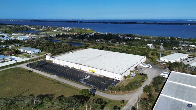
7195 Waelti Dr, Melbourne, FL 32940


NEARBY LISTINGS FOR SALE OR LEASE
Property Detail
7195 Waelti Dr
26-36-12-DE-0000A.0-0000.00
Pineda
Truckterminal
PINEDA ALL BLKS A, 10 THRU 16 & VACATED STREETS & PART OF NW 1/4 OF NE 1/4 OF SECTION 13 LYING N & E OF WICKHAM RD AS DESC IN ORB 2779 PG 2975 & S 1/2 OF VAC ST LYING N OF BLKS 13 THRU 16 EXC ORB 3372 PG 1132, 5827 PG 79 PAR 10 IN SEC 13
A
Brevard
12009C0510H
Florida
2024
13.13 AC
2025
Brevard County
063109
Orlando
222,414 SF
Palm Bay-Melbourne-Titusville, FL
DEMOGRAPHICS near 7195 Waelti Dr
1 Mile
3 Mile
5 Mile
2024 Total Population
4,836
31,904
83,323
2029 Population
5,325
34,858
91,551
Pop Growth 2024-2029
+ 10.11%
+ 9.26%
+ 9.87%
Average Age
50
48
46
2024 Total Households
2,231
13,575
34,416
HH Growth 2024-2029
+ 10.13%
+ 9.13%
+ 9.55%
Median Household Inc
$75,068
$100,245
$93,262
Avg Household Size
2.10
2.30
2.40
2024 Avg HH Vehicles
2.00
2.00
2.00
Median Home Value
$331,171
$351,265
$376,579
Median Year Built
1992
1997
1998
Nearby Places
Map Layers
Map Styles
 Street
 Aerial
- Restaurants
- Banks
- Shops
- Fitness
- Groceries
PUBLIC TRANSPORTATION
AIRPORT
Melbourne Orlando International
DRIVE
WALK
Distance
Melbourne Orlando International
27 min
12.9 mi
SALE & LEASE HISTORY
LISTING DATE
SALE/LEASE

Feb 13, 2025
For Lease
Nearby Properties
Address
Land Use
TOTAL SIZE
Lot Size
Zoning
Address
Land Use
TOTAL SIZE
Lot Size
Zoning
354,864 SF
26.76 AC
PIP
Address
Land Use
TOTAL SIZE
Lot Size
Zoning
406,986 SF
30.50 AC
PUD
Address
Land Use
TOTAL SIZE
Lot Size
Zoning
386,565 SF
11.90 AC
Address
Land Use
TOTAL SIZE
Lot Size
Zoning
224,695 SF
5.26 AC
Address
Land Use
TOTAL SIZE
Lot Size
Zoning
269,541 SF
17.80 AC
PUD
Address
Land Use
TOTAL SIZE
Lot Size
Zoning
134,562 SF
18.25 AC
BU1
Address
Land Use
TOTAL SIZE
Lot Size
Zoning
114,906 SF
16.85 AC
PUD
Address
Land Use
TOTAL SIZE
Lot Size
Zoning
113,498 SF
37.57 AC
PUD
Address
Land Use
TOTAL SIZE
Lot Size
Zoning
96,110 SF
49.65 AC
INH
Address
Land Use
TOTAL SIZE
Lot Size
Zoning
213,915 SF
27.13 AC
BU1
Address
Land Use
TOTAL SIZE
Lot Size
Zoning
133,137 SF
10.59 AC
PUD
Address
Land Use
TOTAL SIZE
Lot Size
Zoning
135,320 SF
16.54 AC
BU1
Address
Land Use
TOTAL SIZE
Lot Size
Zoning
97,430 SF
51.89 AC
BU1
Address
Land Use
TOTAL SIZE
Lot Size
Zoning
69,560 SF
9 AC
PUD
Address
Land Use
TOTAL SIZE
Lot Size
Zoning
170,721 SF
28.52 AC
PIP
Address
Land Use
TOTAL SIZE
Lot Size
Zoning
83,420 SF
5.94 AC
PUD
Address
Land Use
TOTAL SIZE
Lot Size
Zoning
91,470 SF
3.01 AC
BU1
Address
Land Use
TOTAL SIZE
Lot Size
Zoning
178,191 SF
18.19 AC
TU-2
Address
Land Use
TOTAL SIZE
Lot Size
Zoning
54,114 SF
11.48 AC
Address
Land Use
TOTAL SIZE
Lot Size
Zoning
120,600 SF
2.76 AC
Address
Land Use
TOTAL SIZE
Lot Size
Zoning
82,494 SF
11.49 AC
BU1
Address
Land Use
TOTAL SIZE
Lot Size
Zoning
51,042 SF
1.70 AC
TU-2
Address
Land Use
TOTAL SIZE
Lot Size
Zoning
57,069 SF
5.89 AC
Address
Land Use
TOTAL SIZE
Lot Size
Zoning
90,232 SF
10.17 AC
PUD
Address
Land Use
TOTAL SIZE
Lot Size
Zoning
67,313 SF
335.11 AC
PUD
Address
Land Use
TOTAL SIZE
Lot Size
Zoning
79,972 SF
7.20 AC
TU-2
Address
Land Use
TOTAL SIZE
Lot Size
Zoning
112,250 SF
6.76 AC
IU
Address
Land Use
TOTAL SIZE
Lot Size
Zoning
168,229 SF
20.36 AC
BU1/BU2
Address
Land Use
TOTAL SIZE
Lot Size
Zoning
93,520 SF
2.66 AC
PUD
The World's #1 Commercial Real Estate Marketplace
Connect with us
© 2026 CoStar Group
The information above has been obtained from sources believed reliable. While we do not doubt its accuracy we have not verified it and make no guarantee, warranty or representation about it. It is your responsibility to independently confirm its accuracy and completeness. Any projections, opinions, assumptions, or estimates used are for example only and do not represent the current or future performance of the property. The value of this transaction to you depends on tax and other factors which should be evaluated by your tax, financial, and legal advisors. You and your advisors should conduct a careful, independent investigation of the property to determine to your satisfaction the suitability of the property for your needs.