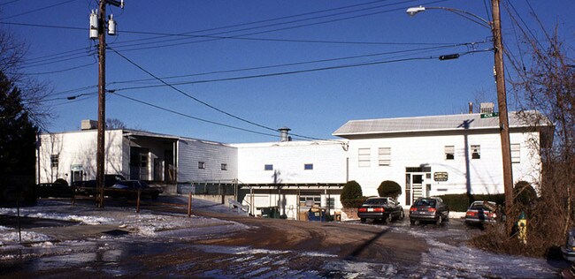
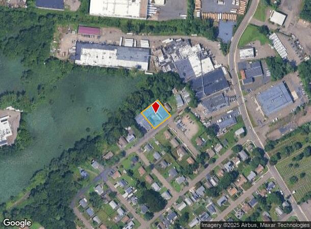
Property Record
72 Acton St, West Haven, CT 06516
NEARBY LISTINGS FOR SALE OR LEASE
Property Detail
72 Acton St
Manufacturinglight
New Haven
X
Connecticut
09009C0436H
0.30 AC
2025
West Haven
2025
Westchester/So Connecticut
154102
New Haven, CT
12,500 SF
WHAV-000052-000104
DEMOGRAPHICS near 72 Acton St
1 Mile
3 Mile
5 Mile
2024 Total Population
14,517
100,068
219,515
2029 Population
14,467
99,012
217,326
Pop Growth 2024-2029
(0.34%)
(1.06%)
(1.00%)
Average Age
35
38
38
2024 Total Households
4,499
38,959
84,358
HH Growth 2024-2029
(0.78%)
(1.01%)
(1.00%)
Median Household Inc
$67,861
$60,797
$65,456
Avg Household Size
2.60
2.30
2.30
2024 Avg HH Vehicles
2.00
1.00
1.00
Median Home Value
$230,856
$247,181
$272,185
Median Year Built
1970
1956
1956
Nearby Places
Map Layers
Map Styles
 Street
 Aerial
- Restaurants
- Banks
- Shops
- Fitness
- Groceries
PUBLIC TRANSPORTATION
COMMUTER RAIL
DRIVE
WALK
Distance
5 min
2.1 mi
DRIVE
WALK
Distance
7 min
3.3 mi
AIRPORT
Tweed/New Haven
DRIVE
WALK
Distance
Tweed/New Haven
17 min
7.5 mi
Long Island MacArthur
DRIVE
WALK
Distance
Long Island MacArthur
130 min
49.0 mi
Freight Ports
Port of New Haven
DRIVE
WALK
Distance
Port of New Haven
11 min
5.3 mi
Nearby Properties
Address
Land Use
TOTAL SIZE
Lot Size
Zoning
Address
Land Use
TOTAL SIZE
Lot Size
Zoning
289,886 SF
2.21 AC
BD2
Address
Land Use
TOTAL SIZE
Lot Size
Zoning
56,359 SF
17.09 AC
RCPD
Address
Land Use
TOTAL SIZE
Lot Size
Zoning
50.14 AC
PRD
Address
Land Use
TOTAL SIZE
Lot Size
Zoning
81,870 SF
3.86 AC
RM2
Address
Land Use
TOTAL SIZE
Lot Size
Zoning
302,262 SF
10.40 AC
RM1
Address
Land Use
TOTAL SIZE
Lot Size
Zoning
133,767 SF
1.25 AC
BD2
Address
Land Use
TOTAL SIZE
Lot Size
Zoning
486,703 SF
2.12 AC
BD
Address
Land Use
TOTAL SIZE
Lot Size
Zoning
72,708 SF
1.91 AC
PDU 87
Address
Land Use
TOTAL SIZE
Lot Size
Zoning
117,902 SF
1.41 AC
BD
Address
Land Use
TOTAL SIZE
Lot Size
Zoning
57,339 SF
3.46 AC
RM2
Address
Land Use
TOTAL SIZE
Lot Size
Zoning
75,139 SF
3.54 AC
RM1
Address
Land Use
TOTAL SIZE
Lot Size
Zoning
42.52 AC
PF
Address
Land Use
TOTAL SIZE
Lot Size
Zoning
287,844 SF
2.11 AC
IL
Address
Land Use
TOTAL SIZE
Lot Size
Zoning
158,622 SF
2.09 AC
BA/RM2
Address
Land Use
TOTAL SIZE
Lot Size
Zoning
29.78 AC
PRD
Address
Land Use
TOTAL SIZE
Lot Size
Zoning
76,945 SF
8.52 AC
RM2
Address
Land Use
TOTAL SIZE
Lot Size
Zoning
35.05 AC
LI-2
Address
Land Use
TOTAL SIZE
Lot Size
Zoning
125,577 SF
0.90 AC
RH2
Address
Land Use
TOTAL SIZE
Lot Size
Zoning
205,756 SF
1.27 AC
PDD 15
Address
Land Use
TOTAL SIZE
Lot Size
Zoning
88,578 SF
0.42 AC
PDD 98
Address
Land Use
TOTAL SIZE
Lot Size
Zoning
43,673 SF
4.84 AC
RM2
Address
Land Use
TOTAL SIZE
Lot Size
Zoning
840,277 SF
4.28 AC
BD2
Address
Land Use
TOTAL SIZE
Lot Size
Zoning
576 SF
RS2
Address
Land Use
TOTAL SIZE
Lot Size
Zoning
119,187 SF
1.38 AC
RO
Address
Land Use
TOTAL SIZE
Lot Size
Zoning
54,372 SF
2.42 AC
BD2
Address
Land Use
TOTAL SIZE
Lot Size
Zoning
125,676 SF
22.12 AC
BOP
Address
Land Use
TOTAL SIZE
Lot Size
Zoning
85,592 SF
1.75 AC
BD1
Address
Land Use
TOTAL SIZE
Lot Size
Zoning
228,347 SF
0.66 AC
BA
Address
Land Use
TOTAL SIZE
Lot Size
Zoning
253,181 SF
1.86 AC
RH2
Address
Land Use
TOTAL SIZE
Lot Size
Zoning
26,560 SF
4.22 AC
RM2
The World's #1 Commercial Real Estate Marketplace
Connect with us
© 2026 CoStar Group
The information above has been obtained from sources believed reliable. While we do not doubt its accuracy we have not verified it and make no guarantee, warranty or representation about it. It is your responsibility to independently confirm its accuracy and completeness. Any projections, opinions, assumptions, or estimates used are for example only and do not represent the current or future performance of the property. The value of this transaction to you depends on tax and other factors which should be evaluated by your tax, financial, and legal advisors. You and your advisors should conduct a careful, independent investigation of the property to determine to your satisfaction the suitability of the property for your needs.