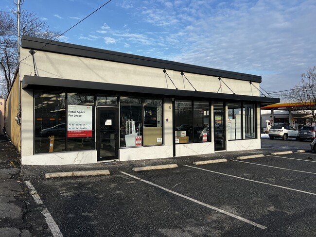
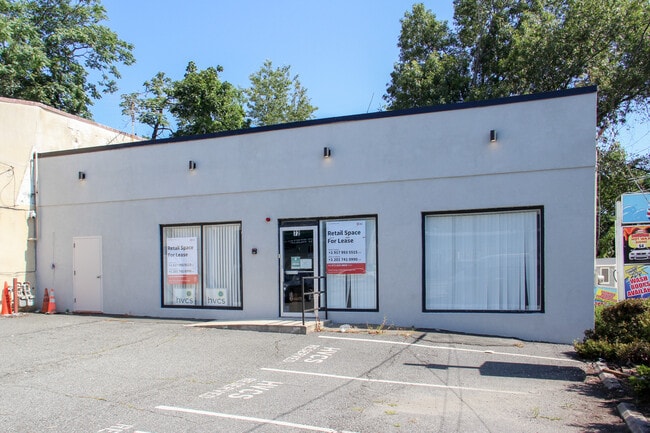
Property Record
72 E Route 59, Spring Valley, NY 10977
Current Lease Availabilities
NEARBY LISTINGS FOR SALE OR LEASE
Property Detail
72 E Route 59
392003-057-057-0001-005-000-0000
6-A-6
Commercialnec
Rockland
X
New York
36087C0156G
5.0
2023
0.28 AC
2024
Ramapo
011305
Northern New Jersey
7,471 SF
New York-Jersey City-White Plains, NY-NJ
DEMOGRAPHICS near 72 E Route 59
1 Mile
3 Mile
5 Mile
2024 Total Population
22,408
146,799
243,590
2029 Population
22,169
145,631
242,809
Pop Growth 2024-2029
(1.07%)
(0.80%)
(0.32%)
Average Age
36
32
36
2024 Total Households
6,627
38,115
69,305
HH Growth 2024-2029
(1.10%)
(0.83%)
(0.27%)
Median Household Inc
$82,967
$82,608
$103,236
Avg Household Size
3.20
3.60
3.30
2024 Avg HH Vehicles
2.00
2.00
2.00
Median Home Value
$368,835
$552,149
$633,013
Median Year Built
1976
1972
1970
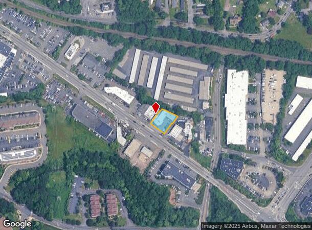
Nearby Places
Map Layers
Map Styles
 Street
 Aerial
- Restaurants
- Banks
- Shops
- Fitness
- Groceries
PUBLIC TRANSPORTATION
TRANSIT/SUBWAY
Spring Valley (Pascack Valley Line - NJ Transit Commuter Rail (NJ Transit))
DRIVE
WALK
Distance
Spring Valley (Pascack Valley Line - NJ Transit Commuter Rail (NJ Transit))
2 min
17 min
0.9 mi
COMMUTER RAIL
Spring Valley (Pascack Valley Line - NJ Transit Commuter Rail (NJ Transit))
DRIVE
WALK
Distance
Spring Valley (Pascack Valley Line - NJ Transit Commuter Rail (NJ Transit))
2 min
17 min
0.9 mi
Nanuet (Pascack Valley Line - NJ Transit Commuter Rail (NJ Transit))
DRIVE
WALK
Distance
Nanuet (Pascack Valley Line - NJ Transit Commuter Rail (NJ Transit))
4 min
1.9 mi
AIRPORT
Westchester County
DRIVE
WALK
Distance
Westchester County
34 min
24.1 mi
LaGuardia
DRIVE
WALK
Distance
LaGuardia
50 min
33.5 mi
New York Stewart International
DRIVE
WALK
Distance
New York Stewart International
55 min
42.7 mi
Freight Ports
Maher Terminal
DRIVE
WALK
Distance
Maher Terminal
50 min
36.3 mi
Nearby Properties
Address
Land Use
TOTAL SIZE
Lot Size
Zoning
Address
Land Use
TOTAL SIZE
Lot Size
Zoning
402,385 SF
23.10 AC
LI
Address
Land Use
TOTAL SIZE
Lot Size
Zoning
63,621 SF
180.20 AC
LI
Address
Land Use
TOTAL SIZE
Lot Size
Zoning
37,600 SF
31.41 AC
Address
Land Use
TOTAL SIZE
Lot Size
Zoning
298,975 SF
63.32 AC
03 - MULTI
Address
Land Use
TOTAL SIZE
Lot Size
Zoning
316,644 SF
65.70 AC
Address
Land Use
TOTAL SIZE
Lot Size
Zoning
116,650 SF
39.20 AC
05
Address
Land Use
TOTAL SIZE
Lot Size
Zoning
50,280 SF
24.37 AC
Address
Land Use
TOTAL SIZE
Lot Size
Zoning
152,854 SF
18.75 AC
RS
Address
Land Use
TOTAL SIZE
Lot Size
Zoning
270,962 SF
21.80 AC
CS
Address
Land Use
TOTAL SIZE
Lot Size
Zoning
67,962 SF
8.30 AC
02 - SINGL
Address
Land Use
TOTAL SIZE
Lot Size
Zoning
345,670 SF
49.40 AC
Address
Land Use
TOTAL SIZE
Lot Size
Zoning
247,496 SF
24.20 AC
Address
Land Use
TOTAL SIZE
Lot Size
Zoning
208,628 SF
11.95 AC
Address
Land Use
TOTAL SIZE
Lot Size
Zoning
68,910 SF
27 AC
Address
Land Use
TOTAL SIZE
Lot Size
Zoning
500,448 SF
29.92 AC
Address
Land Use
TOTAL SIZE
Lot Size
Zoning
2,220 SF
15.10 AC
02 - SINGL
Address
Land Use
TOTAL SIZE
Lot Size
Zoning
129,957 SF
21.90 AC
Address
Land Use
TOTAL SIZE
Lot Size
Zoning
95,890 SF
60 AC
Address
Land Use
TOTAL SIZE
Lot Size
Zoning
150,981 SF
14.85 AC
LO
Address
Land Use
TOTAL SIZE
Lot Size
Zoning
64,784 SF
14.30 AC
RS
Address
Land Use
TOTAL SIZE
Lot Size
Zoning
246,340 SF
14.91 AC
LI
Address
Land Use
TOTAL SIZE
Lot Size
Zoning
117,950 SF
11.13 AC
05
Address
Land Use
TOTAL SIZE
Lot Size
Zoning
141,846 SF
12.81 AC
05
Address
Land Use
TOTAL SIZE
Lot Size
Zoning
275,724 SF
40 AC
R1
Address
Land Use
TOTAL SIZE
Lot Size
Zoning
4,492 SF
14.50 AC
Address
Land Use
TOTAL SIZE
Lot Size
Zoning
64,024 SF
7.30 AC
Address
Land Use
TOTAL SIZE
Lot Size
Zoning
101,628 SF
9.23 AC
05
Address
Land Use
TOTAL SIZE
Lot Size
Zoning
38,056 SF
21.21 AC
R-15C
Address
Land Use
TOTAL SIZE
Lot Size
Zoning
78,895 SF
18.20 AC
Address
Land Use
TOTAL SIZE
Lot Size
Zoning
1,547 SF
6.60 AC
The World's #1 Commercial Real Estate Marketplace
Connect with us
© 2026 CoStar Group
The information above has been obtained from sources believed reliable. While we do not doubt its accuracy we have not verified it and make no guarantee, warranty or representation about it. It is your responsibility to independently confirm its accuracy and completeness. Any projections, opinions, assumptions, or estimates used are for example only and do not represent the current or future performance of the property. The value of this transaction to you depends on tax and other factors which should be evaluated by your tax, financial, and legal advisors. You and your advisors should conduct a careful, independent investigation of the property to determine to your satisfaction the suitability of the property for your needs.