Property Record
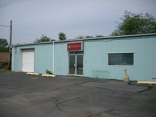
72 Foote Ave, Duryea, PA 18642

NEARBY LISTINGS FOR SALE OR LEASE
-
-
View all Duryea listings for lease on LoopNet.com
Property Detail
72 Foote Ave
Scranton--Wilkes-Barre--Hazelton, PA
14-C-71-R3-D12-3 68 FOOTE AVE
14-D12S1-001-011-000
Luzerne
Miscresidentialimprovement
Pennsylvania
X
11
42079C0234E
0.33 AC
2025
I-81 Corridor
2025
Philadelphia
210500
DEMOGRAPHICS near 72 Foote Ave
1 Mile
3 Mile
5 Mile
2024 Total Population
5,846
38,126
65,654
2029 Population
5,832
37,963
65,304
Pop Growth 2024-2029
(0.24%)
(0.43%)
(0.53%)
Average Age
43
43
44
2024 Total Households
2,478
17,035
29,034
HH Growth 2024-2029
(0.24%)
(0.45%)
(0.53%)
Median Household Inc
$74,636
$64,618
$67,322
Avg Household Size
2.30
2.20
2.20
2024 Avg HH Vehicles
2.00
2.00
2.00
Median Home Value
$146,348
$143,889
$154,831
Median Year Built
1955
1949
1957
Nearby Places
Map Layers
Map Styles
 Street
 Aerial
- Restaurants
- Banks
- Shops
- Fitness
- Groceries
PUBLIC TRANSPORTATION
AIRPORT
Wilkes-Barre/Scranton International
DRIVE
WALK
Distance
Wilkes-Barre/Scranton International
11 min
3.8 mi
Freight Ports
Maher Terminal
DRIVE
WALK
Distance
Maher Terminal
156 min
122.6 mi
SALE & LEASE HISTORY
LISTING DATE
SALE/LEASE

Nov 15, 2019
For Lease
Nearby Properties
Address
Land Use
TOTAL SIZE
Lot Size
Zoning
Address
Land Use
TOTAL SIZE
Lot Size
Zoning
Address
Land Use
TOTAL SIZE
Lot Size
Zoning
130.63 AC
Address
Land Use
TOTAL SIZE
Lot Size
Zoning
92.99 AC
Address
Land Use
TOTAL SIZE
Lot Size
Zoning
59.28 AC
Address
Land Use
TOTAL SIZE
Lot Size
Zoning
46.01 AC
Address
Land Use
TOTAL SIZE
Lot Size
Zoning
51.15 AC
Address
Land Use
TOTAL SIZE
Lot Size
Zoning
43.65 AC
Address
Land Use
TOTAL SIZE
Lot Size
Zoning
50.85 AC
Address
Land Use
TOTAL SIZE
Lot Size
Zoning
24.33 AC
Address
Land Use
TOTAL SIZE
Lot Size
Zoning
34.07 AC
Address
Land Use
TOTAL SIZE
Lot Size
Zoning
15.60 AC
Address
Land Use
TOTAL SIZE
Lot Size
Zoning
28.06 AC
Address
Land Use
TOTAL SIZE
Lot Size
Zoning
27.12 AC
Address
Land Use
TOTAL SIZE
Lot Size
Zoning
24.30 AC
Address
Land Use
TOTAL SIZE
Lot Size
Zoning
8.61 AC
Address
Land Use
TOTAL SIZE
Lot Size
Zoning
21.31 AC
Address
Land Use
TOTAL SIZE
Lot Size
Zoning
5.93 AC
Address
Land Use
TOTAL SIZE
Lot Size
Zoning
14.35 AC
Address
Land Use
TOTAL SIZE
Lot Size
Zoning
4.56 AC
Address
Land Use
TOTAL SIZE
Lot Size
Zoning
9.70 AC
Address
Land Use
TOTAL SIZE
Lot Size
Zoning
Address
Land Use
TOTAL SIZE
Lot Size
Zoning
21.81 AC
Address
Land Use
TOTAL SIZE
Lot Size
Zoning
25.05 AC
Address
Land Use
TOTAL SIZE
Lot Size
Zoning
24.44 AC
Address
Land Use
TOTAL SIZE
Lot Size
Zoning
21.70 AC
Address
Land Use
TOTAL SIZE
Lot Size
Zoning
17.29 AC
Address
Land Use
TOTAL SIZE
Lot Size
Zoning
20.95 AC
Address
Land Use
TOTAL SIZE
Lot Size
Zoning
7.67 AC
Address
Land Use
TOTAL SIZE
Lot Size
Zoning
17.05 AC
The World's #1 Commercial Real Estate Marketplace
Connect with us
© 2025 CoStar Group
The information above has been obtained from sources believed reliable. While we do not doubt its accuracy we have not verified it and make no guarantee, warranty or representation about it. It is your responsibility to independently confirm its accuracy and completeness. Any projections, opinions, assumptions, or estimates used are for example only and do not represent the current or future performance of the property. The value of this transaction to you depends on tax and other factors which should be evaluated by your tax, financial, and legal advisors. You and your advisors should conduct a careful, independent investigation of the property to determine to your satisfaction the suitability of the property for your needs.