Property Record
72 Hamilton Ave, Greenwich, CT 06830
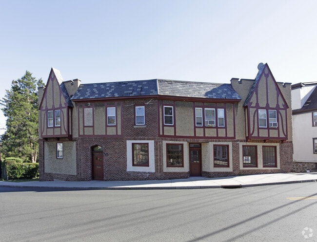


Property Detail
72 Hamilton Ave
Commercialofficeresidentialmixeduse
Western Ct
R-6
Connecticut
B and X Area of moderate flood hazard, usually the area between the limits of the 100-year and 500-year floods.
0.08 AC
2025
Greenwich
2025
Westchester/So Connecticut
010500
Bridgeport-Stamford-Danbury, CT
3,611 SF
GREE-000003-000000-001305-S000000
NEARBY LISTINGS FOR SALE OR LEASE
DEMOGRAPHICS near 72 Hamilton Ave
1 mile
3 mile
5 mile
2025 Total Population
12,193
74,875
140,827
2030 Population
12,449
74,881
142,385
Pop Growth 2025-2030
+ 2.10%
+ 0.01%
+ 1.11%
Average Age
44
42
41
2025 Total Households
5,272
27,241
48,159
HH Growth 2025-2030
+ 2.22%
+ 0.13%
+ 1.16%
Median Household Inc
$120,187
$127,237
$145,088
Avg Household Size
2.30
2.70
2.80
2025 Avg HH Vehicles
2.00
2.00
2.00
Median Home Value
$1,018,583
$945,100
$1,039,759
Median Year Built
1957
1957
1962
Nearby Places
Map Layers
Map Styles
 Street
 Aerial
Layers
 Traffic
 Biking
Places
Listings with unknown addresses are not visible on the map
- Restaurants
- Banks
- Shops
- Fitness
- Groceries
PUBLIC TRANSPORTATION
COMMUTER RAIL
Greenwich Station (New Haven Line - Metro-North Commuter Railroad Company (Metro-North))
Drive
Walk
Distance
Greenwich Station (New Haven Line - Metro-North Commuter Railroad Company (Metro-North))
1 min
12 min
0.6 mi
Port Chester Station (New Haven Line - Metro-North Commuter Railroad Company (Metro-North))
Drive
Walk
Distance
Port Chester Station (New Haven Line - Metro-North Commuter Railroad Company (Metro-North))
4 min
2.5 mi
AIRPORT
Westchester County
Drive
Walk
Distance
Westchester County
14 min
7.3 mi
LaGuardia
Drive
Walk
Distance
LaGuardia
42 min
26.7 mi
John F Kennedy International
Drive
Walk
Distance
John F Kennedy International
48 min
34.3 mi
Freight Ports
NY - Red Hook Container Terminal
Drive
Walk
Distance
NY - Red Hook Container Terminal
56 min
37.2 mi
SALE & LEASE HISTORY
LISTING DATE
SALE/LEASE

Aug 28, 2020
For Lease
Apr 05, 2017
For Lease
Nearby Properties
Address
Land Use
TOTAL SIZE
Lot Size
Zoning
Address
Land Use
TOTAL SIZE
Lot Size
Zoning
5COMMUND
Address
Land Use
TOTAL SIZE
Lot Size
Zoning
244,937 SF
4.20 AC
WB
Address
Land Use
TOTAL SIZE
Lot Size
Zoning
4,179 SF
3.32 AC
GBO
Address
Land Use
TOTAL SIZE
Lot Size
Zoning
7,791 SF
33.47 AC
RA-1
Address
Land Use
TOTAL SIZE
Lot Size
Zoning
175,339 SF
2.12 AC
CGB
Address
Land Use
TOTAL SIZE
Lot Size
Zoning
57,033 SF
33.04 AC
RA-1
Address
Land Use
TOTAL SIZE
Lot Size
Zoning
80,427 SF
18.06 AC
GBO
Address
Land Use
TOTAL SIZE
Lot Size
Zoning
277,172 SF
29.98 AC
CD COMM
Address
Land Use
TOTAL SIZE
Lot Size
Zoning
78,159 SF
4.17 AC
CGB
Address
Land Use
TOTAL SIZE
Lot Size
Zoning
192,254 SF
1.15 AC
GBO
Address
Land Use
TOTAL SIZE
Lot Size
Zoning
9.56 AC
R-6
Address
Land Use
TOTAL SIZE
Lot Size
Zoning
74,446 SF
10.39 AC
R-MF
Address
Land Use
TOTAL SIZE
Lot Size
Zoning
121,807 SF
16.08 AC
R-12
Address
Land Use
TOTAL SIZE
Lot Size
Zoning
9,828 SF
22.01 AC
R-6
Address
Land Use
TOTAL SIZE
Lot Size
Zoning
93,514 SF
5 AC
CGB
Address
Land Use
TOTAL SIZE
Lot Size
Zoning
0.01 AC
5COMMUND
Address
Land Use
TOTAL SIZE
Lot Size
Zoning
32,256 SF
2.63 AC
CGB
Address
Land Use
TOTAL SIZE
Lot Size
Zoning
5COMMUND
Address
Land Use
TOTAL SIZE
Lot Size
Zoning
25,834 SF
12.06 AC
R-MF
Address
Land Use
TOTAL SIZE
Lot Size
Zoning
94,652 SF
2.91 AC
GB
Address
Land Use
TOTAL SIZE
Lot Size
Zoning
345,927 SF
4.32 AC
MUR WTRFR
Address
Land Use
TOTAL SIZE
Lot Size
Zoning
80,054 SF
2.72 AC
CGBR
Address
Land Use
TOTAL SIZE
Lot Size
Zoning
77,136 SF
3.76 AC
GB
Address
Land Use
TOTAL SIZE
Lot Size
Zoning
9,305 SF
35.53 AC
R-C7
Address
Land Use
TOTAL SIZE
Lot Size
Zoning
133,080 SF
1.01 AC
CGBR
Address
Land Use
TOTAL SIZE
Lot Size
Zoning
32,784 SF
2.70 AC
CGB
Address
Land Use
TOTAL SIZE
Lot Size
Zoning
30.60 AC
RA-2
Address
Land Use
TOTAL SIZE
Lot Size
Zoning
811 SF
11.17 AC
RA-2
Address
Land Use
TOTAL SIZE
Lot Size
Zoning
5COMMUND
Address
Land Use
TOTAL SIZE
Lot Size
Zoning
60,317 SF
0.63 AC
CGBR
The World's #1 Commercial Real Estate Marketplace
Connect with us
© 2026 CoStar Group
The information above has been obtained from sources believed reliable. While we do not doubt its accuracy we have not verified it and make no guarantee, warranty or representation about it. It is your responsibility to independently confirm its accuracy and completeness. Any projections, opinions, assumptions, or estimates used are for example only and do not represent the current or future performance of the property. The value of this transaction to you depends on tax and other factors which should be evaluated by your tax, financial, and legal advisors. You and your advisors should conduct a careful, independent investigation of the property to determine to your satisfaction the suitability of the property for your needs.