Property Record
72 Olde Canal Way, Gorham, ME 04038
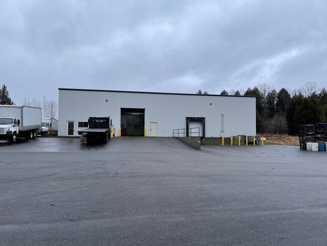

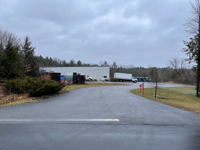
Property Detail
72 Olde Canal Way
GRHM-000034-000003-000005
Cumberland
Warehouse
Maine
I-SZ-R
5
AE The base floodplain where base flood elevations are provided. AE Zones are now used on new format FIRMs instead of A1-A30 Zones.
12.59 AC
2025
SW Cumberland County
2025
Portland/South Portland
004001
Portland-South Portland, ME
11,800 SF
NEARBY LISTINGS FOR SALE OR LEASE
DEMOGRAPHICS near 72 Olde Canal Way
1 mile
3 mile
5 mile
2025 Total Population
259
27,340
53,052
2030 Population
267
28,593
54,816
Pop Growth 2025-2030
+ 3.09%
+ 4.58%
+ 3.33%
Average Age
42
39
40
2025 Total Households
96
10,599
20,728
HH Growth 2025-2030
+ 3.13%
+ 4.60%
+ 3.35%
Median Household Inc
$127,000
$108,556
$106,547
Avg Household Size
2.60
2.40
2.40
2025 Avg HH Vehicles
2.00
2.00
2.00
Median Home Value
$471,666
$456,560
$445,043
Median Year Built
1987
1983
1980
Nearby Places
Map Layers
Map Styles
 Street
 Aerial
Layers
 Traffic
 Biking
Places
Listings with unknown addresses are not visible on the map
- Restaurants
- Banks
- Shops
- Fitness
- Groceries
PUBLIC TRANSPORTATION
COMMUTER RAIL
Portland (Downeaster - Amtrak)
Drive
Walk
Distance
Portland (Downeaster - Amtrak)
18 min
8.2 mi
AIRPORT
Portland International Jetport
Drive
Walk
Distance
Portland International Jetport
18 min
7.5 mi
Freight Ports
Portland, ME
Drive
Walk
Distance
Portland, ME
21 min
10.8 mi
SALE & LEASE HISTORY
LISTING DATE
SALE/LEASE

Jan 24, 2023
For Lease
Jan 24, 2023
For Sale
Nearby Properties
Address
Land Use
TOTAL SIZE
Lot Size
Zoning
Address
Land Use
TOTAL SIZE
Lot Size
Zoning
10.08 AC
Address
Land Use
TOTAL SIZE
Lot Size
Zoning
13.20 AC
I
Address
Land Use
TOTAL SIZE
Lot Size
Zoning
55.70 AC
14
Address
Land Use
TOTAL SIZE
Lot Size
Zoning
19.46 AC
UR
Address
Land Use
TOTAL SIZE
Lot Size
Zoning
139,588 SF
0.85 AC
16
Address
Land Use
TOTAL SIZE
Lot Size
Zoning
93,041 SF
5.53 AC
UR
Address
Land Use
TOTAL SIZE
Lot Size
Zoning
59,965 SF
27.72 AC
R
Address
Land Use
TOTAL SIZE
Lot Size
Zoning
148,964 SF
35.12 AC
UR
Address
Land Use
TOTAL SIZE
Lot Size
Zoning
2,014 SF
189.60 AC
DZ
Address
Land Use
TOTAL SIZE
Lot Size
Zoning
7,860 SF
3.07 AC
UC
Address
Land Use
TOTAL SIZE
Lot Size
Zoning
79.65 AC
UR
Address
Land Use
TOTAL SIZE
Lot Size
Zoning
3.44 AC
27
Address
Land Use
TOTAL SIZE
Lot Size
Zoning
83,135 SF
7.23 AC
11
Address
Land Use
TOTAL SIZE
Lot Size
Zoning
25.14 AC
I
Address
Land Use
TOTAL SIZE
Lot Size
Zoning
60,869 SF
17.96 AC
UR
Address
Land Use
TOTAL SIZE
Lot Size
Zoning
97,200 SF
12.50 AC
12
Address
Land Use
TOTAL SIZE
Lot Size
Zoning
11.27 AC
11
Address
Land Use
TOTAL SIZE
Lot Size
Zoning
9.12 AC
11
Address
Land Use
TOTAL SIZE
Lot Size
Zoning
57,820 SF
8.16 AC
21
Address
Land Use
TOTAL SIZE
Lot Size
Zoning
46,764 SF
4.64 AC
UC
Address
Land Use
TOTAL SIZE
Lot Size
Zoning
Address
Land Use
TOTAL SIZE
Lot Size
Zoning
13.07 AC
11
Address
Land Use
TOTAL SIZE
Lot Size
Zoning
7.20 AC
11
Address
Land Use
TOTAL SIZE
Lot Size
Zoning
171,000 SF
1.47 AC
16
Address
Land Use
TOTAL SIZE
Lot Size
Zoning
183,784 SF
7.20 AC
17
Address
Land Use
TOTAL SIZE
Lot Size
Zoning
114,224 SF
3.48 AC
16
Address
Land Use
TOTAL SIZE
Lot Size
Zoning
14.78 AC
I
Address
Land Use
TOTAL SIZE
Lot Size
Zoning
107,540 SF
18.50 AC
I
Address
Land Use
TOTAL SIZE
Lot Size
Zoning
67,344 SF
0.60 AC
Address
Land Use
TOTAL SIZE
Lot Size
Zoning
83,943 SF
98.39 AC
21
The World's #1 Commercial Real Estate Marketplace
Connect with us
© 2026 CoStar Group
The information above has been obtained from sources believed reliable. While we do not doubt its accuracy we have not verified it and make no guarantee, warranty or representation about it. It is your responsibility to independently confirm its accuracy and completeness. Any projections, opinions, assumptions, or estimates used are for example only and do not represent the current or future performance of the property. The value of this transaction to you depends on tax and other factors which should be evaluated by your tax, financial, and legal advisors. You and your advisors should conduct a careful, independent investigation of the property to determine to your satisfaction the suitability of the property for your needs.