Property Record
72 Rockville Rd, Broad Brook, CT 06016
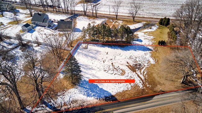

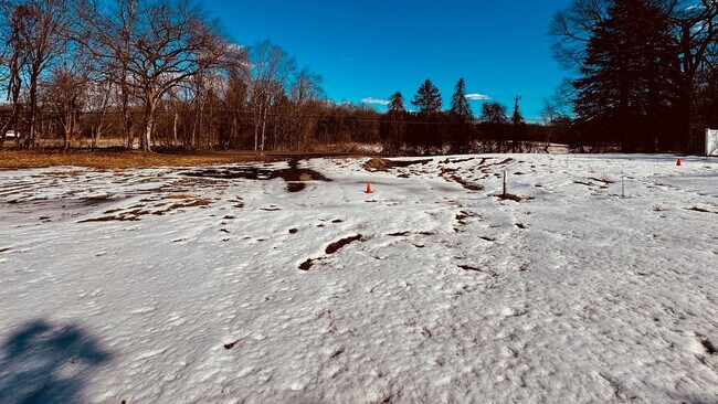
Property Detail
72 Rockville Rd
EWIN-000029-000072-000002
Capitol
Residentialacreage
Connecticut
A-1
2
B and X Area of moderate flood hazard, usually the area between the limits of the 100-year and 500-year floods.
0.72 AC
2025
East Windsor
2025
Hartford
484200
Hartford-West Hartford-East Hartford, CT
1,250 SF
NEARBY LISTINGS FOR SALE OR LEASE
DEMOGRAPHICS near 72 Rockville Rd
1 mile
3 mile
5 mile
2025 Total Population
921
22,249
72,975
2030 Population
935
22,660
74,520
Pop Growth 2025-2030
+ 1.52%
+ 1.85%
+ 2.12%
Average Age
45
43
42
2025 Total Households
358
9,016
31,003
HH Growth 2025-2030
+ 1.68%
+ 1.91%
+ 2.19%
Median Household Inc
$121,474
$121,730
$100,288
Avg Household Size
2.50
2.40
2.30
2025 Avg HH Vehicles
2.00
2.00
2.00
Median Home Value
$327,465
$362,579
$321,397
Median Year Built
1978
1980
1975
Nearby Places
Map Layers
Map Styles
 Street
 Aerial
Layers
 Traffic
 Biking
Places
Listings with unknown addresses are not visible on the map
- Restaurants
- Banks
- Shops
- Fitness
- Groceries
PUBLIC TRANSPORTATION
COMMUTER RAIL
Windsor Locks (Hartford Line - CT Rail (CTRail))
Drive
Walk
Distance
Windsor Locks (Hartford Line - CT Rail (CTRail))
17 min
9.5 mi
AIRPORT
Bradley International
Drive
Walk
Distance
Bradley International
34 min
14.7 mi
Freight Ports
Port of New Haven
Drive
Walk
Distance
Port of New Haven
72 min
50.4 mi
SALE & LEASE HISTORY
LISTING DATE
SALE/LEASE

May 23, 2025
For Sale
Nearby Properties
Address
Land Use
TOTAL SIZE
Lot Size
Zoning
Address
Land Use
TOTAL SIZE
Lot Size
Zoning
3,200 SF
31.39 AC
INDUST
Address
Land Use
TOTAL SIZE
Lot Size
Zoning
52.04 AC
MF
Address
Land Use
TOTAL SIZE
Lot Size
Zoning
40 AC
MF
Address
Land Use
TOTAL SIZE
Lot Size
Zoning
9,244 SF
46.83 AC
MFDD
Address
Land Use
TOTAL SIZE
Lot Size
Zoning
33.41 AC
MF
Address
Land Use
TOTAL SIZE
Lot Size
Zoning
75,238 SF
45.70 AC
R-1
Address
Land Use
TOTAL SIZE
Lot Size
Zoning
85,470 SF
14.11 AC
R
Address
Land Use
TOTAL SIZE
Lot Size
Zoning
71,173 SF
14.30 AC
R-2
Address
Land Use
TOTAL SIZE
Lot Size
Zoning
66,762 SF
17.06 AC
A20
Address
Land Use
TOTAL SIZE
Lot Size
Zoning
31.50 AC
PRD
Address
Land Use
TOTAL SIZE
Lot Size
Zoning
45,666 SF
15.33 AC
RR
Address
Land Use
TOTAL SIZE
Lot Size
Zoning
44,363 SF
23 AC
A20
Address
Land Use
TOTAL SIZE
Lot Size
Zoning
14.80 AC
PRD
Address
Land Use
TOTAL SIZE
Lot Size
Zoning
63,564 SF
7.52 AC
COMMER
Address
Land Use
TOTAL SIZE
Lot Size
Zoning
46,935 SF
20.40 AC
R-22
Address
Land Use
TOTAL SIZE
Lot Size
Zoning
45,495 SF
16.68 AC
R
Address
Land Use
TOTAL SIZE
Lot Size
Zoning
4,066 SF
13.93 AC
ARHD
Address
Land Use
TOTAL SIZE
Lot Size
Zoning
6,349 SF
155.50 AC
M-1
Address
Land Use
TOTAL SIZE
Lot Size
Zoning
1.16 AC
RR
Address
Land Use
TOTAL SIZE
Lot Size
Zoning
37,616 SF
2.70 AC
R-22
Address
Land Use
TOTAL SIZE
Lot Size
Zoning
5.57 AC
PRD
Address
Land Use
TOTAL SIZE
Lot Size
Zoning
9.54 AC
MF
Address
Land Use
TOTAL SIZE
Lot Size
Zoning
35,022 SF
8.12 AC
R-2
Address
Land Use
TOTAL SIZE
Lot Size
Zoning
75.25 AC
RR
Address
Land Use
TOTAL SIZE
Lot Size
Zoning
7.72 AC
INDUST
Address
Land Use
TOTAL SIZE
Lot Size
Zoning
119.58 AC
M-1
Address
Land Use
TOTAL SIZE
Lot Size
Zoning
5,288 SF
1 AC
B-1
Address
Land Use
TOTAL SIZE
Lot Size
Zoning
132.39 AC
R-3
Address
Land Use
TOTAL SIZE
Lot Size
Zoning
16.25 AC
X
Address
Land Use
TOTAL SIZE
Lot Size
Zoning
127.57 AC
R-3
The World's #1 Commercial Real Estate Marketplace
Connect with us
© 2026 CoStar Group
The information above has been obtained from sources believed reliable. While we do not doubt its accuracy we have not verified it and make no guarantee, warranty or representation about it. It is your responsibility to independently confirm its accuracy and completeness. Any projections, opinions, assumptions, or estimates used are for example only and do not represent the current or future performance of the property. The value of this transaction to you depends on tax and other factors which should be evaluated by your tax, financial, and legal advisors. You and your advisors should conduct a careful, independent investigation of the property to determine to your satisfaction the suitability of the property for your needs.