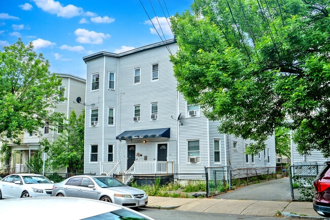
Property Record
72 Thornton St, Revere, MA 02151


NEARBY LISTINGS FOR SALE OR LEASE
Property Detail
72 Thornton St
REVE-000008-000129-000003
Shirley Park
Apartment
Suffolk
X
Massachusetts
25025C0036J
3
2025
0.12 AC
2025
Crescent Beach
170702
Boston
6,237 SF
Boston-Cambridge-Newton, MA-NH
DEMOGRAPHICS near 72 Thornton St
1 Mile
3 Mile
5 Mile
2024 Total Population
30,577
184,386
454,511
2029 Population
28,600
174,309
438,985
Pop Growth 2024-2029
(6.47%)
(5.47%)
(3.42%)
Average Age
39
39
39
2024 Total Households
11,098
66,779
183,832
HH Growth 2024-2029
(6.54%)
(5.77%)
(3.45%)
Median Household Inc
$69,530
$72,613
$84,385
Avg Household Size
2.70
2.70
2.40
2024 Avg HH Vehicles
1.00
1.00
1.00
Median Home Value
$513,377
$535,875
$627,048
Median Year Built
1956
1949
1953
Nearby Places
Map Layers
Map Styles
 Street
 Aerial
- Restaurants
- Banks
- Shops
- Fitness
- Groceries
PUBLIC TRANSPORTATION
TRANSIT/SUBWAY
Revere Beach Station (Blue Line - Massachusetts Bay Transportation Authority Subway (The T))
DRIVE
WALK
Distance
Revere Beach Station (Blue Line - Massachusetts Bay Transportation Authority Subway (The T))
1 min
6 min
0.3 mi
Wonderland Station (Blue Line - Massachusetts Bay Transportation Authority Subway (The T))
DRIVE
WALK
Distance
Wonderland Station (Blue Line - Massachusetts Bay Transportation Authority Subway (The T))
2 min
16 min
0.8 mi
COMMUTER RAIL
Chelsea (Newburyport/Rockport Line - MBTA)
DRIVE
WALK
Distance
Chelsea (Newburyport/Rockport Line - MBTA)
7 min
3.6 mi
River Works (Newburyport/Rockport Line - Massachusetts Bay Transportation Authority Commuter Rail (Purple Line))
DRIVE
WALK
Distance
River Works (Newburyport/Rockport Line - Massachusetts Bay Transportation Authority Commuter Rail (Purple Line))
9 min
4.3 mi
AIRPORT
General Edward Lawrence Logan International
DRIVE
WALK
Distance
General Edward Lawrence Logan International
9 min
4.5 mi
Freight Ports
Port of Boston
DRIVE
WALK
Distance
Port of Boston
15 min
7.2 mi
SALE & LEASE HISTORY
LISTING DATE
SALE/LEASE

Jun 20, 2024
For Sale
Nearby Properties
Address
Land Use
TOTAL SIZE
Lot Size
Zoning
Address
Land Use
TOTAL SIZE
Lot Size
Zoning
171,791 SF
166.88 AC
E
Address
Land Use
TOTAL SIZE
Lot Size
Zoning
8 AC
HB
Address
Land Use
TOTAL SIZE
Lot Size
Zoning
410,642 SF
4.68 AC
CTED
Address
Land Use
TOTAL SIZE
Lot Size
Zoning
247,013 SF
1.13 AC
RC2
Address
Land Use
TOTAL SIZE
Lot Size
Zoning
234,450 SF
3.49 AC
I
Address
Land Use
TOTAL SIZE
Lot Size
Zoning
297,396 SF
2.79 AC
CTED
Address
Land Use
TOTAL SIZE
Lot Size
Zoning
6.73 AC
HB
Address
Land Use
TOTAL SIZE
Lot Size
Zoning
211,294 SF
1.66 AC
RC2
Address
Land Use
TOTAL SIZE
Lot Size
Zoning
224,840 SF
2.18 AC
RC1
Address
Land Use
TOTAL SIZE
Lot Size
Zoning
226,431 SF
4.31 AC
HB
Address
Land Use
TOTAL SIZE
Lot Size
Zoning
359,892 SF
9.06 AC
Address
Land Use
TOTAL SIZE
Lot Size
Zoning
277,750 SF
13.47 AC
LI
Address
Land Use
TOTAL SIZE
Lot Size
Zoning
1.65 AC
RC2
Address
Land Use
TOTAL SIZE
Lot Size
Zoning
6.02 AC
TED
Address
Land Use
TOTAL SIZE
Lot Size
Zoning
362,358 SF
3.44 AC
CTED
Address
Land Use
TOTAL SIZE
Lot Size
Zoning
379,857 SF
7.16 AC
R2
Address
Land Use
TOTAL SIZE
Lot Size
Zoning
422,028 SF
16.10 AC
RB
Address
Land Use
TOTAL SIZE
Lot Size
Zoning
232,943 SF
3.87 AC
Address
Land Use
TOTAL SIZE
Lot Size
Zoning
227,673 SF
1.75 AC
R3
Address
Land Use
TOTAL SIZE
Lot Size
Zoning
172,043 SF
1.13 AC
RC1
Address
Land Use
TOTAL SIZE
Lot Size
Zoning
191,523 SF
2.70 AC
Address
Land Use
TOTAL SIZE
Lot Size
Zoning
5,668 SF
20.05 AC
A
Address
Land Use
TOTAL SIZE
Lot Size
Zoning
391,884 SF
108.79 AC
C
Address
Land Use
TOTAL SIZE
Lot Size
Zoning
738 SF
20.71 AC
PORT
Address
Land Use
TOTAL SIZE
Lot Size
Zoning
362,970 SF
8.36 AC
BH
Address
Land Use
TOTAL SIZE
Lot Size
Zoning
221,856 SF
17.82 AC
ID
Address
Land Use
TOTAL SIZE
Lot Size
Zoning
208,663 SF
2.56 AC
DD
Address
Land Use
TOTAL SIZE
Lot Size
Zoning
449,900 SF
3.38 AC
I
Address
Land Use
TOTAL SIZE
Lot Size
Zoning
303,232 SF
2.52 AC
CTED
Address
Land Use
TOTAL SIZE
Lot Size
Zoning
290,748 SF
7.04 AC
R2
The World's #1 Commercial Real Estate Marketplace
Connect with us
© 2026 CoStar Group
The information above has been obtained from sources believed reliable. While we do not doubt its accuracy we have not verified it and make no guarantee, warranty or representation about it. It is your responsibility to independently confirm its accuracy and completeness. Any projections, opinions, assumptions, or estimates used are for example only and do not represent the current or future performance of the property. The value of this transaction to you depends on tax and other factors which should be evaluated by your tax, financial, and legal advisors. You and your advisors should conduct a careful, independent investigation of the property to determine to your satisfaction the suitability of the property for your needs.