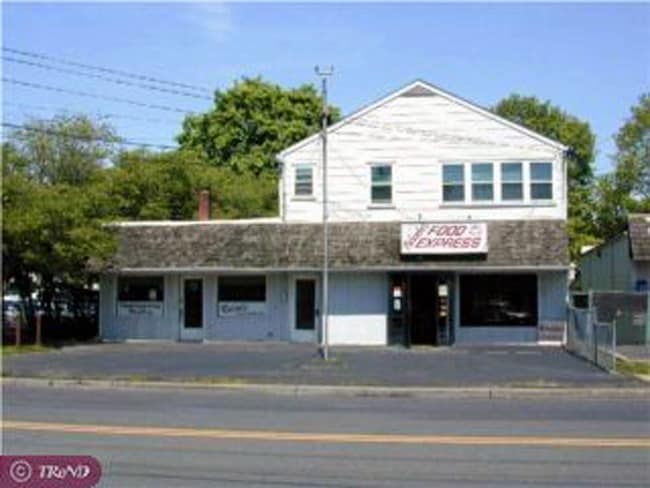
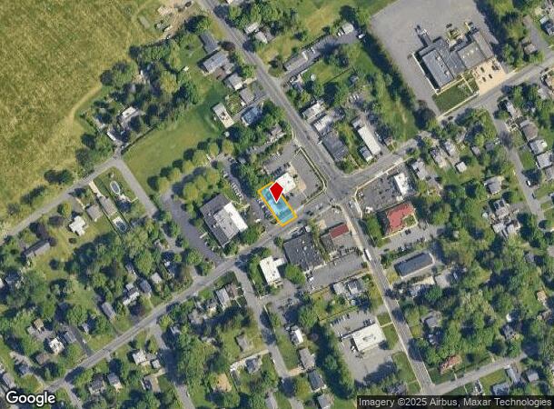
Property Record
72 W Upper Ferry Rd, Ewing, NJ 08628

Property Detail
72 W Upper Ferry Rd
02-00423-0000-00038
ADDITIONAL LOTS: CAFE 72
Vacantlandnec
Mercer
X
New Jersey
34021C0114F
38
2024
0.16 AC
2025
Trenton
003708
Northern New Jersey
4,428 SF
Trenton-Princeton, NJ
NEARBY LISTINGS FOR SALE OR LEASE
DEMOGRAPHICS near 72 W Upper Ferry Rd
1 mile
3 mile
5 mile
2024 Total Population
3,770
54,137
166,500
2029 Population
3,768
53,775
165,339
Pop Growth 2024-2029
(0.05%)
(0.67%)
(0.70%)
Average Age
46
42
41
2024 Total Households
1,738
20,490
63,642
HH Growth 2024-2029
+ 0.46%
(0.81%)
(0.79%)
Median Household Inc
$90,199
$91,052
$86,754
Avg Household Size
2.10
2.40
2.50
2024 Avg HH Vehicles
2.00
2.00
2.00
Median Home Value
$256,455
$291,778
$353,533
Median Year Built
1975
1960
1963
Nearby Places
Map Layers
Map Styles
 Street
 Aerial
Transit
 Traffic
 Biking
Places
Listings with unknown addresses are not visible on the map
- Restaurants
- Banks
- Shops
- Fitness
- Groceries
PUBLIC TRANSPORTATION
TRANSIT/SUBWAY
West Trenton (R3 - Southeastern Pennsylvania Transportation Authority Regional Rail (SEPTA Regional Rail))
Drive
Walk
Distance
West Trenton (R3 - Southeastern Pennsylvania Transportation Authority Regional Rail (SEPTA Regional Rail))
3 min
18 min
0.9 mi
COMMUTER RAIL
West Trenton (R3 - Southeastern Pennsylvania Transportation Authority Regional Rail (SEPTA Regional Rail))
Drive
Walk
Distance
West Trenton (R3 - Southeastern Pennsylvania Transportation Authority Regional Rail (SEPTA Regional Rail))
2 min
14 min
0.7 mi
Yardley (R3 - Southeastern Pennsylvania Transportation Authority Regional Rail (SEPTA Regional Rail))
Drive
Walk
Distance
Yardley (R3 - Southeastern Pennsylvania Transportation Authority Regional Rail (SEPTA Regional Rail))
10 min
5.2 mi
AIRPORT
Trenton Mercer
Drive
Walk
Distance
Trenton Mercer
4 min
1.3 mi
Freight Ports
Port of Philadelphia
Drive
Walk
Distance
Port of Philadelphia
43 min
29.7 mi
SALE & LEASE HISTORY
LISTING DATE
SALE/LEASE

Apr 10, 2024
For Lease
Nearby Properties
Address
Land Use
TOTAL SIZE
Lot Size
Zoning
Address
Land Use
TOTAL SIZE
Lot Size
Zoning
67.65 AC
R-1
Address
Land Use
TOTAL SIZE
Lot Size
Zoning
225.40 AC
R-1
Address
Land Use
TOTAL SIZE
Lot Size
Zoning
1,996 SF
125 AC
RA
Address
Land Use
TOTAL SIZE
Lot Size
Zoning
5.97 AC
R-1
Address
Land Use
TOTAL SIZE
Lot Size
Zoning
2,464 SF
92.96 AC
RO2
Address
Land Use
TOTAL SIZE
Lot Size
Zoning
4,320 SF
12.06 AC
PRO
Address
Land Use
TOTAL SIZE
Lot Size
Zoning
13.86 AC
OP
Address
Land Use
TOTAL SIZE
Lot Size
Zoning
96.60 AC
OP-2
Address
Land Use
TOTAL SIZE
Lot Size
Zoning
117.50 AC
OP-1
Address
Land Use
TOTAL SIZE
Lot Size
Zoning
42.80 AC
IP-1
Address
Land Use
TOTAL SIZE
Lot Size
Zoning
13.36 AC
OP
Address
Land Use
TOTAL SIZE
Lot Size
Zoning
27.21 AC
PRO
Address
Land Use
TOTAL SIZE
Lot Size
Zoning
0.35 AC
OP
Address
Land Use
TOTAL SIZE
Lot Size
Zoning
6.11 AC
R-1
Address
Land Use
TOTAL SIZE
Lot Size
Zoning
104.60 AC
IP-1
Address
Land Use
TOTAL SIZE
Lot Size
Zoning
7.85 AC
OP
Address
Land Use
TOTAL SIZE
Lot Size
Zoning
6.09 AC
OP
Address
Land Use
TOTAL SIZE
Lot Size
Zoning
8.73 AC
OP
Address
Land Use
TOTAL SIZE
Lot Size
Zoning
23.50 AC
R-2
Address
Land Use
TOTAL SIZE
Lot Size
Zoning
Address
Land Use
TOTAL SIZE
Lot Size
Zoning
0.32 AC
OP
Address
Land Use
TOTAL SIZE
Lot Size
Zoning
0.59 AC
RM
Address
Land Use
TOTAL SIZE
Lot Size
Zoning
11.40 AC
Address
Land Use
TOTAL SIZE
Lot Size
Zoning
4.23 AC
R-1
Address
Land Use
TOTAL SIZE
Lot Size
Zoning
64.33 AC
R-2
Address
Land Use
TOTAL SIZE
Lot Size
Zoning
Address
Land Use
TOTAL SIZE
Lot Size
Zoning
8.93 AC
Address
Land Use
TOTAL SIZE
Lot Size
Zoning
6.37 AC
OP
Address
Land Use
TOTAL SIZE
Lot Size
Zoning
34.70 AC
R-1
Address
Land Use
TOTAL SIZE
Lot Size
Zoning
5,254 SF
245.70 AC
R-1
The World's #1 Commercial Real Estate Marketplace
Connect with us
© 2026 CoStar Group
The information above has been obtained from sources believed reliable. While we do not doubt its accuracy we have not verified it and make no guarantee, warranty or representation about it. It is your responsibility to independently confirm its accuracy and completeness. Any projections, opinions, assumptions, or estimates used are for example only and do not represent the current or future performance of the property. The value of this transaction to you depends on tax and other factors which should be evaluated by your tax, financial, and legal advisors. You and your advisors should conduct a careful, independent investigation of the property to determine to your satisfaction the suitability of the property for your needs.