Property Record
720 Lightfoot Rd, Williamsburg, VA 23188
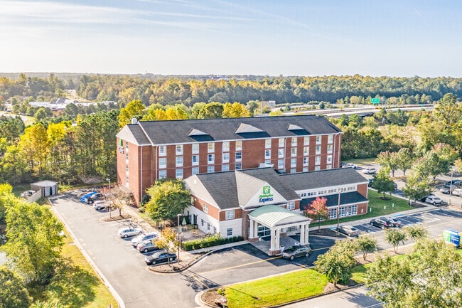

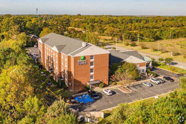
Property Detail
720 Lightfoot Rd
B19B-3735-4358
SPARTA CORP & MIMAR INVEST INC RESUB PARCEL A
Hotel
York
ECONOMIC O
Virginia
B and X Area of moderate flood hazard, usually the area between the limits of the 100-year and 500-year floods.
2.94 AC
2024
Williamsburg
2025
Hampton Roads
051000
Virginia Beach-Chesapeake-Norfolk, VA-NC
68,328 SF
NEARBY LISTINGS FOR SALE OR LEASE
-
-
View all Williamsburg listings for sale on LoopNet.com
DEMOGRAPHICS near 720 Lightfoot Rd
1 mile
3 mile
5 mile
2024 Total Population
1,327
20,467
51,065
2029 Population
1,412
21,239
53,259
Pop Growth 2024-2029
+ 6.41%
+ 3.77%
+ 4.30%
Average Age
47
45
44
2024 Total Households
621
8,666
20,419
HH Growth 2024-2029
+ 6.76%
+ 3.99%
+ 4.77%
Median Household Inc
$71,363
$94,614
$96,298
Avg Household Size
2.10
2.30
2.30
2024 Avg HH Vehicles
1.00
2.00
2.00
Median Home Value
$351,342
$375,372
$409,281
Median Year Built
2003
1997
1999
Nearby Places
Map Layers
Map Styles
 Street
 Aerial
Transit
 Traffic
 Biking
Places
Listings with unknown addresses are not visible on the map
- Restaurants
- Banks
- Shops
- Fitness
- Groceries
PUBLIC TRANSPORTATION
COMMUTER RAIL
Williamsburg Amtrak Station (Northeast Regional - Amtrak)
Drive
Walk
Distance
Williamsburg Amtrak Station (Northeast Regional - Amtrak)
12 min
8.2 mi
AIRPORT
Newport News/Williamsburg International
Drive
Walk
Distance
Newport News/Williamsburg International
32 min
22.8 mi
Freight Ports
Virginia Port Authority - Newport News
Drive
Walk
Distance
Virginia Port Authority - Newport News
45 min
36.8 mi
Nearby Properties
Address
Land Use
TOTAL SIZE
Lot Size
Zoning
Address
Land Use
TOTAL SIZE
Lot Size
Zoning
232,812 SF
77.99 AC
ECONOMIC O
Address
Land Use
TOTAL SIZE
Lot Size
Zoning
10,008 SF
83.06 AC
ECONOMIC O
Address
Land Use
TOTAL SIZE
Lot Size
Zoning
104,404 SF
20.23 AC
PLANNED DE
Address
Land Use
TOTAL SIZE
Lot Size
Zoning
5,184 SF
16.47 AC
PLANNED DE
Address
Land Use
TOTAL SIZE
Lot Size
Zoning
252,940 SF
54.18 AC
PL PUBLIC
Address
Land Use
TOTAL SIZE
Lot Size
Zoning
49,631 SF
15.58 AC
B1 GENERAL
Address
Land Use
TOTAL SIZE
Lot Size
Zoning
3,465 SF
24.94 AC
R5 MULTIFA
Address
Land Use
TOTAL SIZE
Lot Size
Zoning
55,861 SF
18.86 AC
M1 LIMITED
Address
Land Use
TOTAL SIZE
Lot Size
Zoning
23,782 SF
7.52 AC
B1 GENERAL
Address
Land Use
TOTAL SIZE
Lot Size
Zoning
84,280 SF
3.36 AC
B1 GENERAL
Address
Land Use
TOTAL SIZE
Lot Size
Zoning
75,000 SF
442.23 AC
PL PUBLIC
Address
Land Use
TOTAL SIZE
Lot Size
Zoning
68,549 SF
13.22 AC
B1 GENERAL
Address
Land Use
TOTAL SIZE
Lot Size
Zoning
44,406 SF
14.01 AC
M1 LIMITED
Address
Land Use
TOTAL SIZE
Lot Size
Zoning
206,880 SF
23.42 AC
ECONOMIC O
Address
Land Use
TOTAL SIZE
Lot Size
Zoning
124,020 SF
47.19 AC
PL PUBLIC
Address
Land Use
TOTAL SIZE
Lot Size
Zoning
1,736 SF
6.50 AC
PLANNED DE
Address
Land Use
TOTAL SIZE
Lot Size
Zoning
112,708 SF
8.80 AC
R5 MULTIFA
Address
Land Use
TOTAL SIZE
Lot Size
Zoning
201,540 SF
49.76 AC
PL PUBLIC
Address
Land Use
TOTAL SIZE
Lot Size
Zoning
50,400 SF
7.85 AC
B1 GENERAL
Address
Land Use
TOTAL SIZE
Lot Size
Zoning
112,500 SF
16.91 AC
R5 MULTIFA
Address
Land Use
TOTAL SIZE
Lot Size
Zoning
49,225 SF
4.51 AC
B1 GENERAL
Address
Land Use
TOTAL SIZE
Lot Size
Zoning
47,911 SF
7.75 AC
M1 LIMITED
Address
Land Use
TOTAL SIZE
Lot Size
Zoning
120,493 SF
21.26 AC
ECONOMIC O
Address
Land Use
TOTAL SIZE
Lot Size
Zoning
152,877 SF
14.01 AC
ECONOMIC O
Address
Land Use
TOTAL SIZE
Lot Size
Zoning
49,608 SF
10.17 AC
R5 MULTIFA
Address
Land Use
TOTAL SIZE
Lot Size
Zoning
105,024 SF
17.95 AC
ECONOMIC O
Address
Land Use
TOTAL SIZE
Lot Size
Zoning
47,862 SF
7.77 AC
PL PUBLIC
Address
Land Use
TOTAL SIZE
Lot Size
Zoning
2,260 SF
113.08 AC
M1 LIMITED
Address
Land Use
TOTAL SIZE
Lot Size
Zoning
40,398 SF
8.83 AC
ECONOMIC O
The World's #1 Commercial Real Estate Marketplace
Connect with us
© 2026 CoStar Group
The information above has been obtained from sources believed reliable. While we do not doubt its accuracy we have not verified it and make no guarantee, warranty or representation about it. It is your responsibility to independently confirm its accuracy and completeness. Any projections, opinions, assumptions, or estimates used are for example only and do not represent the current or future performance of the property. The value of this transaction to you depends on tax and other factors which should be evaluated by your tax, financial, and legal advisors. You and your advisors should conduct a careful, independent investigation of the property to determine to your satisfaction the suitability of the property for your needs.