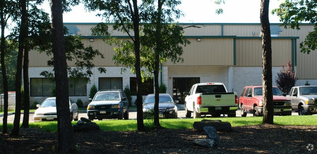
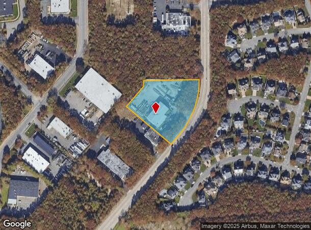
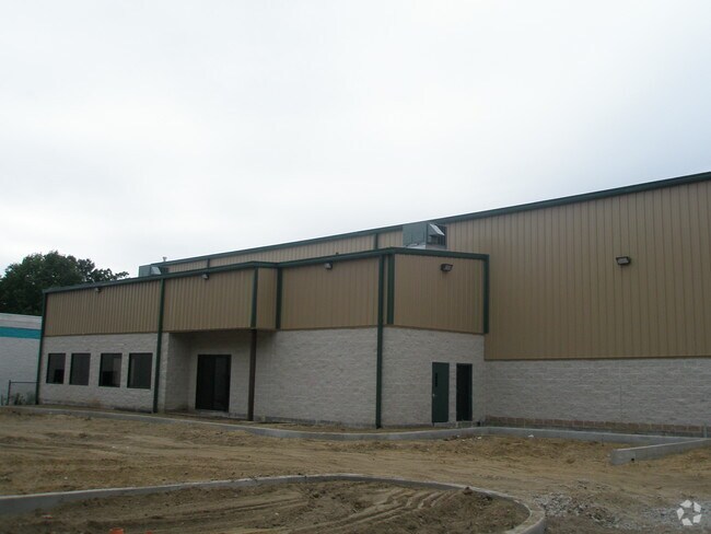
Property Record
720 Blue Point Rd, Holtsville, NY 11742

NEARBY LISTINGS FOR SALE OR LEASE
Property Detail
720 Blue Point Rd
Nassau County-Suffolk County, NY
Richard Smith T A R Webster
0200-835-00-03-00-013-000
BROOKHAVEN CORP PK 8030 E P/O LOT 1
Industrialgeneral
Suffolk
X
New York
36103C0695H
13
2024
2.30 AC
2024
South Central Suffolk
158803
Long Island (New York)
DEMOGRAPHICS near 720 Blue Point Rd
1 Mile
3 Mile
5 Mile
2024 Total Population
8,522
82,422
215,467
2029 Population
8,444
81,446
212,533
Pop Growth 2024-2029
(0.92%)
(1.18%)
(1.36%)
Average Age
41
41
41
2024 Total Households
2,959
28,624
75,298
HH Growth 2024-2029
(1.08%)
(1.33%)
(1.55%)
Median Household Inc
$126,113
$118,671
$108,397
Avg Household Size
2.80
2.80
2.80
2024 Avg HH Vehicles
2.00
2.00
2.00
Median Home Value
$487,012
$443,297
$435,190
Median Year Built
1981
1973
1973
Nearby Places
- Restaurants
- Banks
- Shops
- Fitness
- Groceries
PUBLIC TRANSPORTATION
COMMUTER RAIL
Medford Station (Greenport Branch - Long Island Rail Road)
DRIVE
WALK
Distance
Medford Station (Greenport Branch - Long Island Rail Road)
7 min
3.0 mi
Patchogue Station (Montauk Branch - Long Island Rail Road)
DRIVE
WALK
Distance
Patchogue Station (Montauk Branch - Long Island Rail Road)
9 min
3.9 mi
AIRPORT
Long Island MacArthur
DRIVE
WALK
Distance
Long Island MacArthur
14 min
6.9 mi
Freight Ports
Port of New Haven
DRIVE
WALK
Distance
Port of New Haven
130 min
49.4 mi
Nearby Properties
Address
Land Use
TOTAL SIZE
Lot Size
Zoning
Address
Land Use
TOTAL SIZE
Lot Size
Zoning
30.25 AC
CA
Address
Land Use
TOTAL SIZE
Lot Size
Zoning
95.19 AC
Address
Land Use
TOTAL SIZE
Lot Size
Zoning
29.86 AC
CA
Address
Land Use
TOTAL SIZE
Lot Size
Zoning
26.28 AC
CA
Address
Land Use
TOTAL SIZE
Lot Size
Zoning
23.50 AC
AA
Address
Land Use
TOTAL SIZE
Lot Size
Zoning
96 SF
18.29 AC
BUS3
Address
Land Use
TOTAL SIZE
Lot Size
Zoning
3,025 SF
5.60 AC
AA
Address
Land Use
TOTAL SIZE
Lot Size
Zoning
12.70 AC
IND1
Address
Land Use
TOTAL SIZE
Lot Size
Zoning
42.37 AC
Address
Land Use
TOTAL SIZE
Lot Size
Zoning
14.73 AC
AA
Address
Land Use
TOTAL SIZE
Lot Size
Zoning
11.19 AC
Address
Land Use
TOTAL SIZE
Lot Size
Zoning
16.90 AC
AA
Address
Land Use
TOTAL SIZE
Lot Size
Zoning
19.70 AC
AA
Address
Land Use
TOTAL SIZE
Lot Size
Zoning
14.70 AC
BUS3
Address
Land Use
TOTAL SIZE
Lot Size
Zoning
17.52 AC
ICD
Address
Land Use
TOTAL SIZE
Lot Size
Zoning
14.75 AC
CA
Address
Land Use
TOTAL SIZE
Lot Size
Zoning
3,278 SF
0.51 AC
VILLA
Address
Land Use
TOTAL SIZE
Lot Size
Zoning
3,942 SF
0.45 AC
VILLA
Address
Land Use
TOTAL SIZE
Lot Size
Zoning
13.39 AC
C
Address
Land Use
TOTAL SIZE
Lot Size
Zoning
2,432 SF
21.76 AC
IND1
Address
Land Use
TOTAL SIZE
Lot Size
Zoning
12.32 AC
IND1
Address
Land Use
TOTAL SIZE
Lot Size
Zoning
4.23 AC
IND1
Address
Land Use
TOTAL SIZE
Lot Size
Zoning
11.14 AC
IND1
Address
Land Use
TOTAL SIZE
Lot Size
Zoning
8.10 AC
GSC
Address
Land Use
TOTAL SIZE
Lot Size
Zoning
6,486 SF
0.55 AC
VILLA
Address
Land Use
TOTAL SIZE
Lot Size
Zoning
3,960 SF
0.72 AC
R40
Address
Land Use
TOTAL SIZE
Lot Size
Zoning
8.60 AC
IND1
Address
Land Use
TOTAL SIZE
Lot Size
Zoning
13.52 AC
ICD
Address
Land Use
TOTAL SIZE
Lot Size
Zoning
5.31 AC
C
Address
Land Use
TOTAL SIZE
Lot Size
Zoning
5.23 AC
C
The World's #1 Commercial Real Estate Marketplace
Connect with us
© 2025 CoStar Group
The information above has been obtained from sources believed reliable. While we do not doubt its accuracy we have not verified it and make no guarantee, warranty or representation about it. It is your responsibility to independently confirm its accuracy and completeness. Any projections, opinions, assumptions, or estimates used are for example only and do not represent the current or future performance of the property. The value of this transaction to you depends on tax and other factors which should be evaluated by your tax, financial, and legal advisors. You and your advisors should conduct a careful, independent investigation of the property to determine to your satisfaction the suitability of the property for your needs.