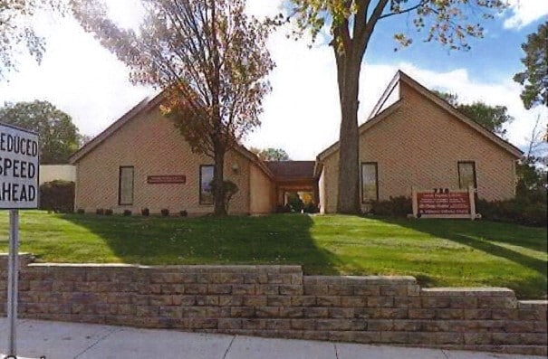
Property Record
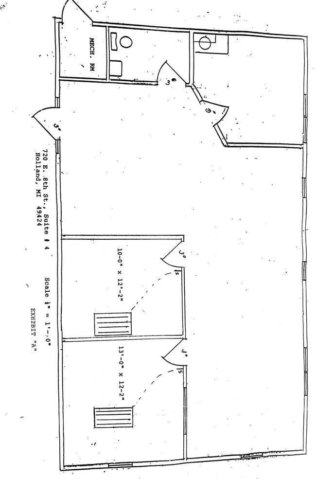
720 E 8Th St, Holland, MI 49423

Property Detail
720 E 8Th St
70-16-27-300-004
COM 2436 FT E OF NW COR SW 1/4 TH S 312 FT E 113 FT N 312 FT W 113 FT TO BEG SEC 27 T5 R15
Officebuilding
Ottawa
C-5
Michigan
B and X Area of moderate flood hazard, usually the area between the limits of the 100-year and 500-year floods.
0.72 AC
2025
Holland East
2025
West Michigan
025200
Grand Rapids-Wyoming-Kentwood, MI
4,784 SF
NEARBY LISTINGS FOR SALE OR LEASE
DEMOGRAPHICS near 720 E 8Th St
1 mile
3 mile
5 mile
2025 Total Population
5,750
54,408
95,721
2030 Population
5,803
55,322
97,476
Pop Growth 2025-2030
+ 0.92%
+ 1.68%
+ 1.83%
Average Age
38
39
39
2025 Total Households
2,347
20,335
35,567
HH Growth 2025-2030
+ 1.07%
+ 1.88%
+ 1.98%
Median Household Inc
$55,401
$70,502
$76,617
Avg Household Size
2.30
2.50
2.60
2025 Avg HH Vehicles
2.00
2.00
2.00
Median Home Value
$251,001
$261,969
$283,573
Median Year Built
1976
1981
1984
Nearby Places
Map Layers
Map Styles
 Street
 Aerial
Layers
 Traffic
 Biking
Places
Listings with unknown addresses are not visible on the map
- Restaurants
- Banks
- Shops
- Fitness
- Groceries
PUBLIC TRANSPORTATION
COMMUTER RAIL
Drive
Walk
Distance
3 min
1.2 mi
AIRPORT
Gerald R Ford International
Drive
Walk
Distance
Gerald R Ford International
44 min
33.0 mi
SALE & LEASE HISTORY
LISTING DATE
SALE/LEASE

Sep 25, 2016
For Lease
Oct 03, 2022
For Lease
Nov 18, 2020
For Lease
Jun 19, 2020
For Lease
Nearby Properties
Address
Land Use
TOTAL SIZE
Lot Size
Zoning
Address
Land Use
TOTAL SIZE
Lot Size
Zoning
1,599,294 SF
Address
Land Use
TOTAL SIZE
Lot Size
Zoning
572,832 SF
10.89 AC
PUD
Address
Land Use
TOTAL SIZE
Lot Size
Zoning
1,788,352 SF
173.33 AC
Address
Land Use
TOTAL SIZE
Lot Size
Zoning
682,378 SF
99.60 AC
NA
Address
Land Use
TOTAL SIZE
Lot Size
Zoning
662,015 SF
177 AC
SEE MAP
Address
Land Use
TOTAL SIZE
Lot Size
Zoning
198,712 SF
Address
Land Use
TOTAL SIZE
Lot Size
Zoning
630,943 SF
28.50 AC
Address
Land Use
TOTAL SIZE
Lot Size
Zoning
346,440 SF
32.15 AC
PUD
Address
Land Use
TOTAL SIZE
Lot Size
Zoning
249,051 SF
24.77 AC
LDR
Address
Land Use
TOTAL SIZE
Lot Size
Zoning
660,002 SF
32.13 AC
I-2
Address
Land Use
TOTAL SIZE
Lot Size
Zoning
218,722 SF
8.59 AC
AGR
Address
Land Use
TOTAL SIZE
Lot Size
Zoning
320,270 SF
33.25 AC
PUD
Address
Land Use
TOTAL SIZE
Lot Size
Zoning
329,784 SF
38.51 AC
I-2
Address
Land Use
TOTAL SIZE
Lot Size
Zoning
226,347 SF
19.44 AC
I-2
Address
Land Use
TOTAL SIZE
Lot Size
Zoning
674,052 SF
79.30 AC
Address
Land Use
TOTAL SIZE
Lot Size
Zoning
132,127 SF
42.69 AC
SEE MAP
Address
Land Use
TOTAL SIZE
Lot Size
Zoning
239,465 SF
Address
Land Use
TOTAL SIZE
Lot Size
Zoning
210,792 SF
22.91 AC
C-2
Address
Land Use
TOTAL SIZE
Lot Size
Zoning
94,790 SF
1.74 AC
C-2
Address
Land Use
TOTAL SIZE
Lot Size
Zoning
58,710 SF
6.96 AC
C-2
Address
Land Use
TOTAL SIZE
Lot Size
Zoning
150,822 SF
Address
Land Use
TOTAL SIZE
Lot Size
Zoning
209,455 SF
17 AC
C-2
Address
Land Use
TOTAL SIZE
Lot Size
Zoning
177,800 SF
12.34 AC
I-2
Address
Land Use
TOTAL SIZE
Lot Size
Zoning
134,490 SF
15.76 AC
C-2
Address
Land Use
TOTAL SIZE
Lot Size
Zoning
136,520 SF
13.55 AC
PUD
Address
Land Use
TOTAL SIZE
Lot Size
Zoning
65.75 AC
PUD
Address
Land Use
TOTAL SIZE
Lot Size
Zoning
1,801 SF
23.26 AC
PUD
Address
Land Use
TOTAL SIZE
Lot Size
Zoning
228,876 SF
49.31 AC
GMU
Address
Land Use
TOTAL SIZE
Lot Size
Zoning
372,017 SF
17.60 AC
R-2
Address
Land Use
TOTAL SIZE
Lot Size
Zoning
184,944 SF
12.57 AC
R-3
The World's #1 Commercial Real Estate Marketplace
Connect with us
© 2026 CoStar Group
The information above has been obtained from sources believed reliable. While we do not doubt its accuracy we have not verified it and make no guarantee, warranty or representation about it. It is your responsibility to independently confirm its accuracy and completeness. Any projections, opinions, assumptions, or estimates used are for example only and do not represent the current or future performance of the property. The value of this transaction to you depends on tax and other factors which should be evaluated by your tax, financial, and legal advisors. You and your advisors should conduct a careful, independent investigation of the property to determine to your satisfaction the suitability of the property for your needs.