Property Record
720 Main St, Dalton, MA 01226
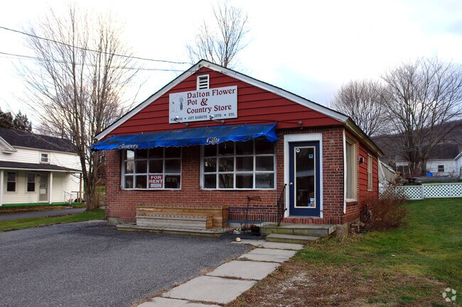

Property Detail
720 Main St
DALT-000113-000000-000121
BERKSHIRE
Storebuilding
Massachusetts
R3
121
2025
0.19 AC
2025
Other Market Areas
912100
Pittsfield, MA
832 SF
NEARBY LISTINGS FOR SALE OR LEASE
DEMOGRAPHICS near 720 Main St
1 mile
3 mile
5 mile
2025 Total Population
3,665
8,836
33,367
2030 Population
3,541
8,530
32,319
Pop Growth 2025-2030
(3.38%)
(3.46%)
(3.14%)
Average Age
45
47
45
2025 Total Households
1,579
3,892
14,938
HH Growth 2025-2030
(3.42%)
(3.60%)
(3.08%)
Median Household Inc
$77,891
$78,901
$73,543
Avg Household Size
2.20
2.10
2.10
2025 Avg HH Vehicles
2.00
2.00
2.00
Median Home Value
$257,378
$268,359
$259,557
Median Year Built
1954
1957
1952
Nearby Places
Map Layers
Map Styles
 Street
 Aerial
Layers
 Traffic
 Biking
Places
Listings with unknown addresses are not visible on the map
- Restaurants
- Banks
- Shops
- Fitness
- Groceries
PUBLIC TRANSPORTATION
COMMUTER RAIL
Pittsfield Amtrak Station (Empire Service - Amtrak, Lake Shore Limited - Amtrak)
Drive
Walk
Distance
Pittsfield Amtrak Station (Empire Service - Amtrak, Lake Shore Limited - Amtrak)
11 min
5.6 mi
Freight Ports
Albany, NY Port
Drive
Walk
Distance
Albany, NY Port
73 min
45.6 mi
Nearby Properties
Address
Land Use
TOTAL SIZE
Lot Size
Zoning
Address
Land Use
TOTAL SIZE
Lot Size
Zoning
92 AC
R-4
Address
Land Use
TOTAL SIZE
Lot Size
Zoning
600 SF
19.89 AC
R20
Address
Land Use
TOTAL SIZE
Lot Size
Zoning
Address
Land Use
TOTAL SIZE
Lot Size
Zoning
266 AC
R5
Address
Land Use
TOTAL SIZE
Lot Size
Zoning
14.63 AC
IG
Address
Land Use
TOTAL SIZE
Lot Size
Zoning
165,400 SF
0.49 AC
IG
Address
Land Use
TOTAL SIZE
Lot Size
Zoning
22.83 AC
I2
Address
Land Use
TOTAL SIZE
Lot Size
Zoning
14.40 AC
I1
Address
Land Use
TOTAL SIZE
Lot Size
Zoning
11.60 AC
I2
Address
Land Use
TOTAL SIZE
Lot Size
Zoning
57,170 SF
18.87 AC
R1
Address
Land Use
TOTAL SIZE
Lot Size
Zoning
12.50 AC
RG
Address
Land Use
TOTAL SIZE
Lot Size
Zoning
87,081 SF
11.50 AC
IG
Address
Land Use
TOTAL SIZE
Lot Size
Zoning
242,525 SF
12.52 AC
BC
Address
Land Use
TOTAL SIZE
Lot Size
Zoning
128,036 SF
14.92 AC
IG
Address
Land Use
TOTAL SIZE
Lot Size
Zoning
79,095 SF
14.89 AC
IG
Address
Land Use
TOTAL SIZE
Lot Size
Zoning
183,260 SF
6 AC
IG
Address
Land Use
TOTAL SIZE
Lot Size
Zoning
11.77 AC
IG
Address
Land Use
TOTAL SIZE
Lot Size
Zoning
86.21 AC
MC
Address
Land Use
TOTAL SIZE
Lot Size
Zoning
102,954 SF
11.98 AC
IG
Address
Land Use
TOTAL SIZE
Lot Size
Zoning
35 AC
RG
Address
Land Use
TOTAL SIZE
Lot Size
Zoning
8.20 AC
R-3
Address
Land Use
TOTAL SIZE
Lot Size
Zoning
28 AC
I2
Address
Land Use
TOTAL SIZE
Lot Size
Zoning
124,490 SF
8.22 AC
B
Address
Land Use
TOTAL SIZE
Lot Size
Zoning
6.09 AC
BC
Address
Land Use
TOTAL SIZE
Lot Size
Zoning
32,518 SF
3.30 AC
R3
Address
Land Use
TOTAL SIZE
Lot Size
Zoning
2.30 AC
R3
Address
Land Use
TOTAL SIZE
Lot Size
Zoning
78,400 SF
29.27 AC
IG
Address
Land Use
TOTAL SIZE
Lot Size
Zoning
120,989 SF
6.38 AC
IG
Address
Land Use
TOTAL SIZE
Lot Size
Zoning
272,670 SF
50.61 AC
PIDD
Address
Land Use
TOTAL SIZE
Lot Size
Zoning
99,600 SF
8.60 AC
LDI
The World's #1 Commercial Real Estate Marketplace
Connect with us
© 2026 CoStar Group
The information above has been obtained from sources believed reliable. While we do not doubt its accuracy we have not verified it and make no guarantee, warranty or representation about it. It is your responsibility to independently confirm its accuracy and completeness. Any projections, opinions, assumptions, or estimates used are for example only and do not represent the current or future performance of the property. The value of this transaction to you depends on tax and other factors which should be evaluated by your tax, financial, and legal advisors. You and your advisors should conduct a careful, independent investigation of the property to determine to your satisfaction the suitability of the property for your needs.