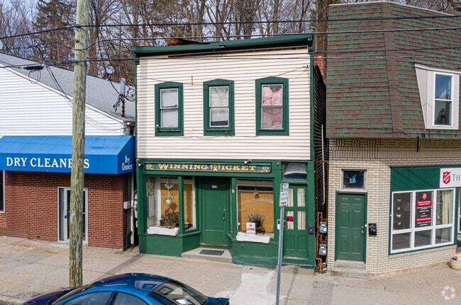
Property Record
720 Main St, Winsted, CT 06098

Property Detail
720 Main St
WINC-000110-000047-000011
Nw Hills
Commercialofficeresidentialmixeduse
Connecticut
CB-3
11
2025
0.07 AC
2025
Rt 8/Winsted
320101
Hartford
1,909 SF
Torrington, CT
NEARBY LISTINGS FOR SALE OR LEASE
DEMOGRAPHICS near 720 Main St
1 mile
3 mile
5 mile
2025 Total Population
5,174
10,626
18,616
2030 Population
5,236
10,803
19,028
Pop Growth 2025-2030
+ 1.20%
+ 1.67%
+ 2.21%
Average Age
44
45
45
2025 Total Households
2,367
4,819
8,006
HH Growth 2025-2030
+ 1.14%
+ 1.70%
+ 2.26%
Median Household Inc
$67,257
$70,698
$85,742
Avg Household Size
2.20
2.20
2.30
2025 Avg HH Vehicles
2.00
2.00
2.00
Median Home Value
$257,449
$267,447
$290,925
Median Year Built
1948
1953
1966
Nearby Places
Map Layers
Map Styles
 Street
 Aerial
Transit
 Traffic
 Biking
Places
Listings with unknown addresses are not visible on the map
- Restaurants
- Banks
- Shops
- Fitness
- Groceries
PUBLIC TRANSPORTATION
AIRPORT
Bradley International
Drive
Walk
Distance
Bradley International
53 min
25.1 mi
Freight Ports
Port of New Haven
Drive
Walk
Distance
Port of New Haven
76 min
54.6 mi
SALE & LEASE HISTORY
LISTING DATE
SALE/LEASE

Sep 24, 2016
For Sale
Oct 22, 2019
For Sale
Nearby Properties
Address
Land Use
TOTAL SIZE
Lot Size
Zoning
Address
Land Use
TOTAL SIZE
Lot Size
Zoning
224,385 SF
26.20 AC
RU-2
Address
Land Use
TOTAL SIZE
Lot Size
Zoning
13.79 AC
CX
Address
Land Use
TOTAL SIZE
Lot Size
Zoning
95,810 SF
5.60 AC
R-3
Address
Land Use
TOTAL SIZE
Lot Size
Zoning
76,339 SF
124.53 AC
R-1
Address
Land Use
TOTAL SIZE
Lot Size
Zoning
20,544 SF
2.42 AC
CB-2
Address
Land Use
TOTAL SIZE
Lot Size
Zoning
56,852 SF
3 AC
R-3
Address
Land Use
TOTAL SIZE
Lot Size
Zoning
54,920 SF
11.87 AC
R-3
Address
Land Use
TOTAL SIZE
Lot Size
Zoning
24,618 SF
3.63 AC
CB-2
Address
Land Use
TOTAL SIZE
Lot Size
Zoning
5.11 AC
R-3
Address
Land Use
TOTAL SIZE
Lot Size
Zoning
2.32 AC
CB-2
Address
Land Use
TOTAL SIZE
Lot Size
Zoning
9,976 SF
13.10 AC
RU-2
Address
Land Use
TOTAL SIZE
Lot Size
Zoning
53,252 SF
32.19 AC
RU-1
Address
Land Use
TOTAL SIZE
Lot Size
Zoning
32,000 SF
6.33 AC
IB-1
Address
Land Use
TOTAL SIZE
Lot Size
Zoning
7,888 SF
8.72 AC
RU-2
Address
Land Use
TOTAL SIZE
Lot Size
Zoning
33,268 SF
5.27 AC
RA-2
Address
Land Use
TOTAL SIZE
Lot Size
Zoning
2.21 AC
IB-1
Address
Land Use
TOTAL SIZE
Lot Size
Zoning
50,068 SF
1.97 AC
R-3
Address
Land Use
TOTAL SIZE
Lot Size
Zoning
24,000 SF
0.44 AC
CB-2
Address
Land Use
TOTAL SIZE
Lot Size
Zoning
120,472 SF
28.82 AC
IA-1
Address
Land Use
TOTAL SIZE
Lot Size
Zoning
42,850 SF
0.36 AC
CB-3
Address
Land Use
TOTAL SIZE
Lot Size
Zoning
45 AC
RU-1
Address
Land Use
TOTAL SIZE
Lot Size
Zoning
3.17 AC
IB-3
Address
Land Use
TOTAL SIZE
Lot Size
Zoning
12,960 SF
244.96 AC
RU-3
Address
Land Use
TOTAL SIZE
Lot Size
Zoning
10,125 SF
1.34 AC
CB-2
Address
Land Use
TOTAL SIZE
Lot Size
Zoning
7,225 SF
4.90 AC
B-2
Address
Land Use
TOTAL SIZE
Lot Size
Zoning
28,226 SF
0.96 AC
CX
Address
Land Use
TOTAL SIZE
Lot Size
Zoning
38,896 SF
0.96 AC
IB-1
Address
Land Use
TOTAL SIZE
Lot Size
Zoning
88,168 SF
14.59 AC
IA-1
Address
Land Use
TOTAL SIZE
Lot Size
Zoning
29,968 SF
3.72 AC
R-4
Address
Land Use
TOTAL SIZE
Lot Size
Zoning
81,171 SF
17.55 AC
IB-1
The World's #1 Commercial Real Estate Marketplace
Connect with us
© 2026 CoStar Group
The information above has been obtained from sources believed reliable. While we do not doubt its accuracy we have not verified it and make no guarantee, warranty or representation about it. It is your responsibility to independently confirm its accuracy and completeness. Any projections, opinions, assumptions, or estimates used are for example only and do not represent the current or future performance of the property. The value of this transaction to you depends on tax and other factors which should be evaluated by your tax, financial, and legal advisors. You and your advisors should conduct a careful, independent investigation of the property to determine to your satisfaction the suitability of the property for your needs.