Property Record
720 N Ventura Rd, Port Hueneme, CA 93041
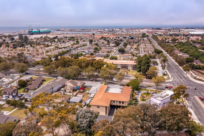
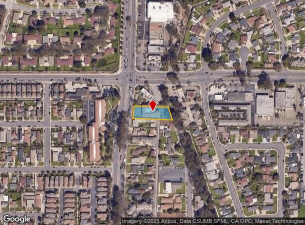


This Property Is For Sale
NEARBY LISTINGS FOR SALE OR LEASE
Property Detail
720 N Ventura Rd
207-0-130-410
El Rio De Santa Clara Ola Co
Officebuilding
MAP 3 PG 13 PART OF LOT 2
X
Ventura
06111C0914F
California
2024
0.44 AC
2025
Oxnard/Port Hueneme
004400
Los Angeles
9,892 SF
Oxnard-Thousand Oaks-Ventura, CA
DEMOGRAPHICS near 720 N Ventura Rd
1 Mile
3 Mile
5 Mile
2024 Total Population
25,801
132,060
199,070
2029 Population
25,787
130,644
196,595
Pop Growth 2024-2029
(0.05%)
(1.07%)
(1.24%)
Average Age
34
37
37
2024 Total Households
7,087
35,784
54,417
HH Growth 2024-2029
+ 0.31%
(0.73%)
(1.00%)
Median Household Inc
$65,693
$78,033
$82,375
Avg Household Size
3.40
3.50
3.50
2024 Avg HH Vehicles
2.00
2.00
2.00
Median Home Value
$489,903
$531,634
$600,498
Median Year Built
1970
1972
1973
Nearby Places
Map Layers
Map Styles
 Street
 Aerial
- Restaurants
- Banks
- Shops
- Fitness
- Groceries
PUBLIC TRANSPORTATION
COMMUTER RAIL
Oxnard (Ventura County Line - Southern California Regional Rail Authority (Metrolink))
DRIVE
WALK
Distance
Oxnard (Ventura County Line - Southern California Regional Rail Authority (Metrolink))
8 min
4.3 mi
East Ventura Metrolink Station (Metrolink Ventura County Line - Metrolink Trains)
DRIVE
WALK
Distance
East Ventura Metrolink Station (Metrolink Ventura County Line - Metrolink Trains)
15 min
9.0 mi
Freight Ports
The Port of Hueneme
DRIVE
WALK
Distance
The Port of Hueneme
2 min
0.6 mi
Nearby Properties
Address
Land Use
TOTAL SIZE
Lot Size
Zoning
Address
Land Use
TOTAL SIZE
Lot Size
Zoning
241,298 SF
8 AC
R3C
Address
Land Use
TOTAL SIZE
Lot Size
Zoning
90,086 SF
10.48 AC
CDI
Address
Land Use
TOTAL SIZE
Lot Size
Zoning
11.28 AC
CMPD
Address
Land Use
TOTAL SIZE
Lot Size
Zoning
166,920 SF
7.15 AC
R3PD
Address
Land Use
TOTAL SIZE
Lot Size
Zoning
129,018 SF
5.09 AC
R3PD
Address
Land Use
TOTAL SIZE
Lot Size
Zoning
133,174 SF
5.94 AC
R3PD
Address
Land Use
TOTAL SIZE
Lot Size
Zoning
157,108 SF
21.40 AC
MULT
Address
Land Use
TOTAL SIZE
Lot Size
Zoning
20,349 SF
9.65 AC
C2
Address
Land Use
TOTAL SIZE
Lot Size
Zoning
81,233 SF
3.29 AC
R3PD
Address
Land Use
TOTAL SIZE
Lot Size
Zoning
79,117 SF
3.25 AC
R3PD
Address
Land Use
TOTAL SIZE
Lot Size
Zoning
Address
Land Use
TOTAL SIZE
Lot Size
Zoning
94,375 SF
7.94 AC
Address
Land Use
TOTAL SIZE
Lot Size
Zoning
51,694 SF
2.75 AC
Address
Land Use
TOTAL SIZE
Lot Size
Zoning
14,931 SF
14.08 AC
Address
Land Use
TOTAL SIZE
Lot Size
Zoning
70,600 SF
3.75 AC
R3PD
Address
Land Use
TOTAL SIZE
Lot Size
Zoning
98,276 SF
14 AC
R3
Address
Land Use
TOTAL SIZE
Lot Size
Zoning
2,264 SF
13.03 AC
M1
Address
Land Use
TOTAL SIZE
Lot Size
Zoning
80,002 SF
3.16 AC
MLPD
Address
Land Use
TOTAL SIZE
Lot Size
Zoning
79,556 SF
4.54 AC
Address
Land Use
TOTAL SIZE
Lot Size
Zoning
81,052 SF
11.23 AC
M1PD
Address
Land Use
TOTAL SIZE
Lot Size
Zoning
108,430 SF
5.90 AC
Address
Land Use
TOTAL SIZE
Lot Size
Zoning
48,720 SF
2.76 AC
R2PD
Address
Land Use
TOTAL SIZE
Lot Size
Zoning
56,230 SF
1.19 AC
Address
Land Use
TOTAL SIZE
Lot Size
Zoning
32,410 SF
1.40 AC
MLPD
Address
Land Use
TOTAL SIZE
Lot Size
Zoning
71,845 SF
3.01 AC
COPD
Address
Land Use
TOTAL SIZE
Lot Size
Zoning
2.76 AC
BRP
Address
Land Use
TOTAL SIZE
Lot Size
Zoning
80,440 SF
6.80 AC
M2
Address
Land Use
TOTAL SIZE
Lot Size
Zoning
57,224 SF
3.17 AC
R1
Address
Land Use
TOTAL SIZE
Lot Size
Zoning
58,400 SF
4.89 AC
Address
Land Use
TOTAL SIZE
Lot Size
Zoning
87,167 SF
4.95 AC
The World's #1 Commercial Real Estate Marketplace
Connect with us
© 2025 CoStar Group
The information above has been obtained from sources believed reliable. While we do not doubt its accuracy we have not verified it and make no guarantee, warranty or representation about it. It is your responsibility to independently confirm its accuracy and completeness. Any projections, opinions, assumptions, or estimates used are for example only and do not represent the current or future performance of the property. The value of this transaction to you depends on tax and other factors which should be evaluated by your tax, financial, and legal advisors. You and your advisors should conduct a careful, independent investigation of the property to determine to your satisfaction the suitability of the property for your needs.