Property Record
720 Ronell St, Saint Peter, MN 56082
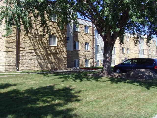
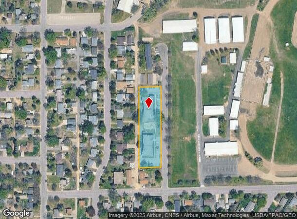
Property Detail
720 Ronell St
Mankato, MN
Fairview Subd
R-19.531.0040
LOT 4 5 6 7 8 9 SUBDIVISIONCD 19531 SUBDIVISIONNAME FAIRVIEW SUBD
Commercialnec
Nicollet
X
Minnesota
27079C0230E
4-9
2025
1.34 AC
2025
Minnesota South Area
480300
Other Market Areas
25,664 SF
NEARBY LISTINGS FOR SALE OR LEASE
DEMOGRAPHICS near 720 Ronell St
1 mile
3 mile
5 mile
2024 Total Population
6,359
13,801
15,264
2029 Population
6,427
13,976
15,475
Pop Growth 2024-2029
+ 1.07%
+ 1.27%
+ 1.38%
Average Age
37
37
38
2024 Total Households
2,305
4,396
4,933
HH Growth 2024-2029
+ 1.21%
+ 1.46%
+ 1.58%
Median Household Inc
$63,284
$68,487
$70,519
Avg Household Size
2.40
2.40
2.40
2024 Avg HH Vehicles
2.00
2.00
2.00
Median Home Value
$213,586
$239,110
$242,431
Median Year Built
1975
1980
1980
Nearby Places
Map Layers
Map Styles
 Street
 Aerial
Transit
 Traffic
 Biking
Places
Listings with unknown addresses are not visible on the map
- Restaurants
- Banks
- Shops
- Fitness
- Groceries
Nearby Properties
Address
Land Use
TOTAL SIZE
Lot Size
Zoning
Address
Land Use
TOTAL SIZE
Lot Size
Zoning
2,796 SF
195.71 AC
Address
Land Use
TOTAL SIZE
Lot Size
Zoning
8,904 SF
379.75 AC
Address
Land Use
TOTAL SIZE
Lot Size
Zoning
60.21 AC
Address
Land Use
TOTAL SIZE
Lot Size
Zoning
91,208 SF
11.43 AC
Address
Land Use
TOTAL SIZE
Lot Size
Zoning
198,703 SF
25 AC
Address
Land Use
TOTAL SIZE
Lot Size
Zoning
91,208 SF
7.41 AC
Address
Land Use
TOTAL SIZE
Lot Size
Zoning
95,177 SF
2.42 AC
Address
Land Use
TOTAL SIZE
Lot Size
Zoning
80,721 SF
4.33 AC
Address
Land Use
TOTAL SIZE
Lot Size
Zoning
80,721 SF
4.43 AC
Address
Land Use
TOTAL SIZE
Lot Size
Zoning
54,606 SF
20.63 AC
Address
Land Use
TOTAL SIZE
Lot Size
Zoning
36,984 SF
2.42 AC
Address
Land Use
TOTAL SIZE
Lot Size
Zoning
66,155 SF
3.27 AC
Address
Land Use
TOTAL SIZE
Lot Size
Zoning
96,093 SF
7.16 AC
Address
Land Use
TOTAL SIZE
Lot Size
Zoning
63,346 SF
2.42 AC
Address
Land Use
TOTAL SIZE
Lot Size
Zoning
4,928 SF
4.60 AC
Address
Land Use
TOTAL SIZE
Lot Size
Zoning
74,595 SF
2.12 AC
Address
Land Use
TOTAL SIZE
Lot Size
Zoning
60,582 SF
15.30 AC
Address
Land Use
TOTAL SIZE
Lot Size
Zoning
27,437 SF
2.12 AC
Address
Land Use
TOTAL SIZE
Lot Size
Zoning
68,065 SF
6.08 AC
Address
Land Use
TOTAL SIZE
Lot Size
Zoning
60,342 SF
1.13 AC
Address
Land Use
TOTAL SIZE
Lot Size
Zoning
19,677 SF
9.52 AC
Address
Land Use
TOTAL SIZE
Lot Size
Zoning
20,871 SF
4.29 AC
Address
Land Use
TOTAL SIZE
Lot Size
Zoning
89,280 SF
4.60 AC
Address
Land Use
TOTAL SIZE
Lot Size
Zoning
1,214 SF
4 AC
Address
Land Use
TOTAL SIZE
Lot Size
Zoning
51,063 SF
2.26 AC
Address
Land Use
TOTAL SIZE
Lot Size
Zoning
7,392 SF
3.22 AC
Address
Land Use
TOTAL SIZE
Lot Size
Zoning
4,674 SF
9.39 AC
Address
Land Use
TOTAL SIZE
Lot Size
Zoning
14,964 SF
0.70 AC
Address
Land Use
TOTAL SIZE
Lot Size
Zoning
35,856 SF
3.01 AC
Address
Land Use
TOTAL SIZE
Lot Size
Zoning
40,458 SF
2.13 AC
The World's #1 Commercial Real Estate Marketplace
Connect with us
© 2026 CoStar Group
The information above has been obtained from sources believed reliable. While we do not doubt its accuracy we have not verified it and make no guarantee, warranty or representation about it. It is your responsibility to independently confirm its accuracy and completeness. Any projections, opinions, assumptions, or estimates used are for example only and do not represent the current or future performance of the property. The value of this transaction to you depends on tax and other factors which should be evaluated by your tax, financial, and legal advisors. You and your advisors should conduct a careful, independent investigation of the property to determine to your satisfaction the suitability of the property for your needs.