Property Record
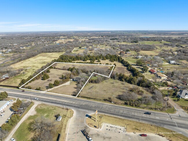
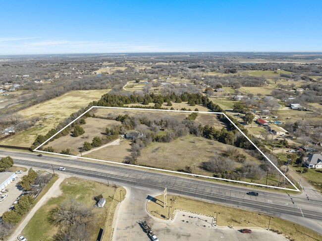
720 S Robinson Dr, Robinson, TX 76706

Property Detail
720 S Robinson Dr
Waco, TX
MARTINEZ M TRACT 20B ACRES 0.56
44-002400-007200-9
McLennan
Privatepreserveopenspacevacantlandforestlandconservation
Texas
C
20b
B and X Area of moderate flood hazard, usually the area between the limits of the 100-year and 500-year floods.
0.56 AC
2024
Waco
2025
Other Market Areas
002000
NEARBY LISTINGS FOR SALE OR LEASE
DEMOGRAPHICS near 720 S Robinson Dr
1 mile
3 mile
5 mile
2025 Total Population
3,221
10,830
38,563
2030 Population
3,387
11,265
39,967
Pop Growth 2025-2030
+ 5.15%
+ 4.02%
+ 3.64%
Average Age
40
40
37
2025 Total Households
1,166
3,867
14,449
HH Growth 2025-2030
+ 5.23%
+ 4.06%
+ 3.66%
Median Household Inc
$88,782
$96,128
$67,246
Avg Household Size
2.70
2.80
2.60
2025 Avg HH Vehicles
2.00
2.00
2.00
Median Home Value
$323,457
$325,384
$242,927
Median Year Built
1991
1991
1990
Nearby Places
Map Layers
Map Styles
 Street
 Aerial
Layers
 Traffic
 Biking
Places
Listings with unknown addresses are not visible on the map
- Restaurants
- Banks
- Shops
- Fitness
- Groceries
PUBLIC TRANSPORTATION
AIRPORT
Waco Regional
Drive
Walk
Distance
Waco Regional
26 min
14.6 mi
Freight Ports
Port of Houston
Drive
Walk
Distance
Port of Houston
216 min
188.8 mi
SALE & LEASE HISTORY
LISTING DATE
SALE/LEASE

Jan 26, 2024
For Sale
Nearby Properties
Address
Land Use
TOTAL SIZE
Lot Size
Zoning
Address
Land Use
TOTAL SIZE
Lot Size
Zoning
78.95 AC
Address
Land Use
TOTAL SIZE
Lot Size
Zoning
342,646 SF
63.20 AC
Address
Land Use
TOTAL SIZE
Lot Size
Zoning
47,912 SF
7.20 AC
Address
Land Use
TOTAL SIZE
Lot Size
Zoning
12,658 SF
115.68 AC
M1
Address
Land Use
TOTAL SIZE
Lot Size
Zoning
400.45 AC
R
Address
Land Use
TOTAL SIZE
Lot Size
Zoning
71,900 SF
30 AC
R
Address
Land Use
TOTAL SIZE
Lot Size
Zoning
110,787 SF
11.60 AC
Address
Land Use
TOTAL SIZE
Lot Size
Zoning
43,696 SF
19.94 AC
C
Address
Land Use
TOTAL SIZE
Lot Size
Zoning
64,021 SF
23.55 AC
C
Address
Land Use
TOTAL SIZE
Lot Size
Zoning
41,503 SF
10.67 AC
Address
Land Use
TOTAL SIZE
Lot Size
Zoning
16,058 SF
10.94 AC
M1
Address
Land Use
TOTAL SIZE
Lot Size
Zoning
34,680 SF
5.19 AC
C
Address
Land Use
TOTAL SIZE
Lot Size
Zoning
1,409 SF
25.24 AC
Address
Land Use
TOTAL SIZE
Lot Size
Zoning
4,598 SF
1.59 AC
C
Address
Land Use
TOTAL SIZE
Lot Size
Zoning
28,007 SF
4 AC
C
Address
Land Use
TOTAL SIZE
Lot Size
Zoning
4,452 SF
3.40 AC
Address
Land Use
TOTAL SIZE
Lot Size
Zoning
20,000 SF
7.56 AC
R
Address
Land Use
TOTAL SIZE
Lot Size
Zoning
2,760 SF
1.02 AC
Address
Land Use
TOTAL SIZE
Lot Size
Zoning
5.37 AC
Address
Land Use
TOTAL SIZE
Lot Size
Zoning
4,480 SF
1.10 AC
Address
Land Use
TOTAL SIZE
Lot Size
Zoning
12,733 SF
0.90 AC
C
Address
Land Use
TOTAL SIZE
Lot Size
Zoning
64,942 SF
5.49 AC
C
Address
Land Use
TOTAL SIZE
Lot Size
Zoning
18,064 SF
1.66 AC
C
Address
Land Use
TOTAL SIZE
Lot Size
Zoning
10,972 SF
6.37 AC
Address
Land Use
TOTAL SIZE
Lot Size
Zoning
11,200 SF
0.97 AC
C
Address
Land Use
TOTAL SIZE
Lot Size
Zoning
314.11 AC
R1A
Address
Land Use
TOTAL SIZE
Lot Size
Zoning
6,398 SF
0.75 AC
C
Address
Land Use
TOTAL SIZE
Lot Size
Zoning
9,140 SF
10.86 AC
R
Address
Land Use
TOTAL SIZE
Lot Size
Zoning
6,678 SF
2.04 AC
Address
Land Use
TOTAL SIZE
Lot Size
Zoning
15,552 SF
4.97 AC
R
The World's #1 Commercial Real Estate Marketplace
Connect with us
© 2026 CoStar Group
The information above has been obtained from sources believed reliable. While we do not doubt its accuracy we have not verified it and make no guarantee, warranty or representation about it. It is your responsibility to independently confirm its accuracy and completeness. Any projections, opinions, assumptions, or estimates used are for example only and do not represent the current or future performance of the property. The value of this transaction to you depends on tax and other factors which should be evaluated by your tax, financial, and legal advisors. You and your advisors should conduct a careful, independent investigation of the property to determine to your satisfaction the suitability of the property for your needs.