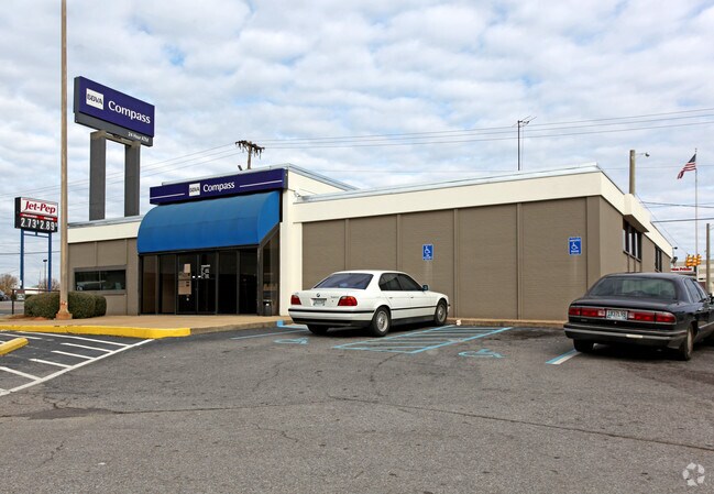
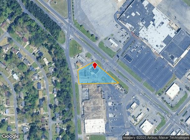
Property Record
7200 Aaron Aronov Dr, Fairfield, AL 35064

NEARBY LISTINGS FOR SALE OR LEASE
Property Detail
7200 Aaron Aronov Dr
30-00-13-3-009-002.000
BEGIN AT THE SW COR OF LOT SAID PT BEING THE PT OF INTER OF THE E R/W OF GRASELLI RD & THE S LINE OF THE SW 1/4 SEC 13 T 18 S R 4 W TH N 141.8 FT ALONG TH E ER/W OF GRASSELLI RD TH NELY 193.2 FT TO A PT ON THE SW R/W OF WEIBEL DR TH SELY 345 FT S ALO
Financialbuilding
Jefferson
X
Alabama
01073C0533G
said
2023
1.39 AC
2024
Bessemer
010603
Birmingham
3,829 SF
Birmingham-Hoover, AL
DEMOGRAPHICS near 7200 Aaron Aronov Dr
1 Mile
3 Mile
5 Mile
2024 Total Population
7,593
54,479
119,771
2029 Population
7,461
54,390
119,626
Pop Growth 2024-2029
(1.74%)
(0.16%)
(0.12%)
Average Age
41
41
41
2024 Total Households
3,042
22,486
50,680
HH Growth 2024-2029
(1.84%)
(0.28%)
(0.15%)
Median Household Inc
$42,523
$39,137
$40,770
Avg Household Size
2.40
2.30
2.20
2024 Avg HH Vehicles
2.00
2.00
2.00
Median Home Value
$93,776
$76,398
$97,820
Median Year Built
1961
1959
1966
Nearby Places
Map Layers
Map Styles
 Street
 Aerial
- Restaurants
- Banks
- Shops
- Fitness
- Groceries
PUBLIC TRANSPORTATION
COMMUTER RAIL
Birmingham (Crescent - Amtrak)
DRIVE
WALK
Distance
Birmingham (Crescent - Amtrak)
12 min
7.8 mi
AIRPORT
Birmingham-Shuttlesworth International
DRIVE
WALK
Distance
Birmingham-Shuttlesworth International
21 min
12.9 mi
Freight Ports
Port of Mobile
DRIVE
WALK
Distance
Port of Mobile
288 min
262.0 mi
Nearby Properties
Address
Land Use
TOTAL SIZE
Lot Size
Zoning
Address
Land Use
TOTAL SIZE
Lot Size
Zoning
1.77 AC
QO&I
Address
Land Use
TOTAL SIZE
Lot Size
Zoning
1,244,986 SF
I2
Address
Land Use
TOTAL SIZE
Lot Size
Zoning
2,573,547 SF
112 AC
I2
Address
Land Use
TOTAL SIZE
Lot Size
Zoning
127,240 SF
3.50 AC
R4
Address
Land Use
TOTAL SIZE
Lot Size
Zoning
200,650 SF
19.48 AC
R4
Address
Land Use
TOTAL SIZE
Lot Size
Zoning
116,442 SF
2.67 AC
B6
Address
Land Use
TOTAL SIZE
Lot Size
Zoning
191,664 SF
14.73 AC
R4
Address
Land Use
TOTAL SIZE
Lot Size
Zoning
48,320 SF
7.81 AC
I3
Address
Land Use
TOTAL SIZE
Lot Size
Zoning
288,000 SF
39.40 AC
I2-I
Address
Land Use
TOTAL SIZE
Lot Size
Zoning
250,918 SF
10 AC
B-2
Address
Land Use
TOTAL SIZE
Lot Size
Zoning
46,155 SF
0.77 AC
R4
Address
Land Use
TOTAL SIZE
Lot Size
Zoning
101,671 SF
14.73 AC
B2
Address
Land Use
TOTAL SIZE
Lot Size
Zoning
114,345 SF
11.20 AC
I-3
Address
Land Use
TOTAL SIZE
Lot Size
Zoning
218,210 SF
11.24 AC
CM-2
Address
Land Use
TOTAL SIZE
Lot Size
Zoning
37,619 SF
9.36 AC
R3
Address
Land Use
TOTAL SIZE
Lot Size
Zoning
29,906 SF
5.40 AC
I3
Address
Land Use
TOTAL SIZE
Lot Size
Zoning
65,260 SF
5.29 AC
B2
Address
Land Use
TOTAL SIZE
Lot Size
Zoning
66,935 SF
1.99 AC
B2
Address
Land Use
TOTAL SIZE
Lot Size
Zoning
157,183 SF
6.50 AC
B2
Address
Land Use
TOTAL SIZE
Lot Size
Zoning
104,775 SF
9.40 AC
B-2
Address
Land Use
TOTAL SIZE
Lot Size
Zoning
1,437,077 SF
I2
Address
Land Use
TOTAL SIZE
Lot Size
Zoning
94,026 SF
4.90 AC
I2R2
Address
Land Use
TOTAL SIZE
Lot Size
Zoning
3,644 SF
10.60 AC
CM2
Address
Land Use
TOTAL SIZE
Lot Size
Zoning
45,666 SF
3.46 AC
R5
Address
Land Use
TOTAL SIZE
Lot Size
Zoning
96,543 SF
8.80 AC
B2
Address
Land Use
TOTAL SIZE
Lot Size
Zoning
34,509 SF
0.52 AC
R3
Address
Land Use
TOTAL SIZE
Lot Size
Zoning
44,043 SF
11.10 AC
I-3
Address
Land Use
TOTAL SIZE
Lot Size
Zoning
11,490 SF
8 AC
CM2
Address
Land Use
TOTAL SIZE
Lot Size
Zoning
95,991 SF
4.66 AC
R5
Address
Land Use
TOTAL SIZE
Lot Size
Zoning
37,793 SF
2.57 AC
R3
The World's #1 Commercial Real Estate Marketplace
Connect with us
© 2025 CoStar Group
The information above has been obtained from sources believed reliable. While we do not doubt its accuracy we have not verified it and make no guarantee, warranty or representation about it. It is your responsibility to independently confirm its accuracy and completeness. Any projections, opinions, assumptions, or estimates used are for example only and do not represent the current or future performance of the property. The value of this transaction to you depends on tax and other factors which should be evaluated by your tax, financial, and legal advisors. You and your advisors should conduct a careful, independent investigation of the property to determine to your satisfaction the suitability of the property for your needs.