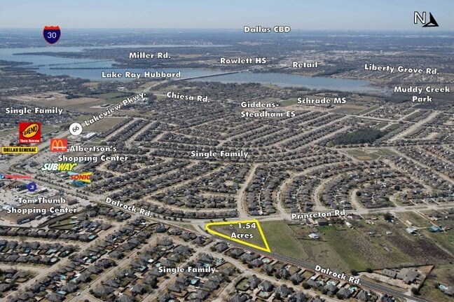
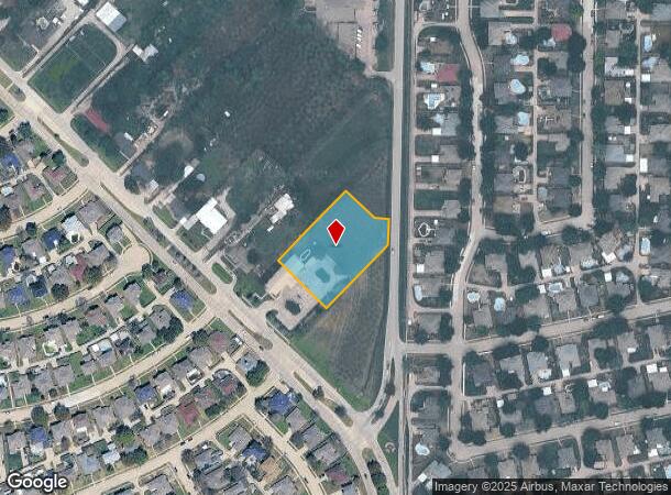
Property Record
7200 Dalrock Rd, Rowlett, TX 75089
NEARBY LISTINGS FOR SALE OR LEASE
Property Detail
7200 Dalrock Rd
Dallas-Fort Worth-Arlington, TX
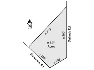
Church Of The Nazarene
44001250010010000
CHURCH OF THE NAZARENE BLK 1 LOT 1 ACS 1.3948 INT202400184124 DD09112024 CO-DC 0012500100100 2CW00125001
Commercialacreage
Dallas
X
Texas
48113C0245K
1
0
1.40 AC
2025
Garland
018143
Dallas/Ft Worth
DEMOGRAPHICS near 7200 Dalrock Rd
1 Mile
3 Mile
5 Mile
2024 Total Population
13,253
47,024
146,724
2029 Population
14,864
52,173
170,142
Pop Growth 2024-2029
+ 12.16%
+ 10.95%
+ 15.96%
Average Age
38
39
39
2024 Total Households
4,380
16,021
50,841
HH Growth 2024-2029
+ 13.84%
+ 11.57%
+ 16.50%
Median Household Inc
$106,384
$109,218
$108,152
Avg Household Size
3.00
2.90
2.80
2024 Avg HH Vehicles
2.00
2.00
2.00
Median Home Value
$268,579
$282,227
$299,177
Median Year Built
1996
1997
1999
Nearby Places
Map Layers
Map Styles
 Street
 Aerial
- Restaurants
- Banks
- Shops
- Fitness
- Groceries
PUBLIC TRANSPORTATION
AIRPORT
Dallas Love Field
DRIVE
WALK
Distance
Dallas Love Field
41 min
26.2 mi
Freight Ports
Port of Shreveport
DRIVE
WALK
Distance
Port of Shreveport
213 min
189.1 mi
Nearby Properties
Address
Land Use
TOTAL SIZE
Lot Size
Zoning
Address
Land Use
TOTAL SIZE
Lot Size
Zoning
252,909 SF
11.73 AC
Address
Land Use
TOTAL SIZE
Lot Size
Zoning
427,231 SF
9.96 AC
Z38
Address
Land Use
TOTAL SIZE
Lot Size
Zoning
43,600 SF
62.86 AC
Z306
Address
Land Use
TOTAL SIZE
Lot Size
Zoning
420,500 SF
33.25 AC
Address
Land Use
TOTAL SIZE
Lot Size
Zoning
261,000 SF
1 AC
Z318
Address
Land Use
TOTAL SIZE
Lot Size
Zoning
244,338 SF
4.44 AC
Address
Land Use
TOTAL SIZE
Lot Size
Zoning
271,051 SF
10.28 AC
Z01
Address
Land Use
TOTAL SIZE
Lot Size
Zoning
43.27 AC
Z80
Address
Land Use
TOTAL SIZE
Lot Size
Zoning
83,296 SF
14.88 AC
Z01
Address
Land Use
TOTAL SIZE
Lot Size
Zoning
151,893 SF
5.40 AC
Z308
Address
Land Use
TOTAL SIZE
Lot Size
Zoning
82,847 SF
4.87 AC
Z236
Address
Land Use
TOTAL SIZE
Lot Size
Zoning
140,000 SF
12.76 AC
Address
Land Use
TOTAL SIZE
Lot Size
Zoning
141,200 SF
10.81 AC
Address
Land Use
TOTAL SIZE
Lot Size
Zoning
52,797 SF
5.41 AC
Z92
Address
Land Use
TOTAL SIZE
Lot Size
Zoning
147.23 AC
Z114
Address
Land Use
TOTAL SIZE
Lot Size
Zoning
0.02 AC
Z236
Address
Land Use
TOTAL SIZE
Lot Size
Zoning
46,718 SF
0.65 AC
Address
Land Use
TOTAL SIZE
Lot Size
Zoning
45,800 SF
5.06 AC
Z92
Address
Land Use
TOTAL SIZE
Lot Size
Zoning
52,051 SF
6.98 AC
Address
Land Use
TOTAL SIZE
Lot Size
Zoning
173,756 SF
14.17 AC
Z92
Address
Land Use
TOTAL SIZE
Lot Size
Zoning
141,200 SF
16.80 AC
Address
Land Use
TOTAL SIZE
Lot Size
Zoning
227.41 AC
PD3
Address
Land Use
TOTAL SIZE
Lot Size
Zoning
22,771 SF
4.22 AC
Z309
Address
Land Use
TOTAL SIZE
Lot Size
Zoning
39,005 SF
4.68 AC
Address
Land Use
TOTAL SIZE
Lot Size
Zoning
3,027 SF
108.32 AC
SUP
Address
Land Use
TOTAL SIZE
Lot Size
Zoning
94,600 SF
7.15 AC
Address
Land Use
TOTAL SIZE
Lot Size
Zoning
93,501 SF
9.09 AC
Address
Land Use
TOTAL SIZE
Lot Size
Zoning
19,026 SF
77.70 AC
Z236
Address
Land Use
TOTAL SIZE
Lot Size
Zoning
25,575 SF
12.93 AC
Z236
Address
Land Use
TOTAL SIZE
Lot Size
Zoning
170,000 SF
5.50 AC
Z306
The World's #1 Commercial Real Estate Marketplace
Connect with us
© 2025 CoStar Group
The information above has been obtained from sources believed reliable. While we do not doubt its accuracy we have not verified it and make no guarantee, warranty or representation about it. It is your responsibility to independently confirm its accuracy and completeness. Any projections, opinions, assumptions, or estimates used are for example only and do not represent the current or future performance of the property. The value of this transaction to you depends on tax and other factors which should be evaluated by your tax, financial, and legal advisors. You and your advisors should conduct a careful, independent investigation of the property to determine to your satisfaction the suitability of the property for your needs.